
Small-scale map of Kīlauea's ERZ flow field

Detailed Description
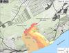
Map showing the Kahauale‘a 2 flow in relation to the eastern part of the Island of Hawai‘i as of April 28, 2014. The most distant active front of the Kahauale‘a 2 flow was just over 8.3 km (5.2 miles) straight-line distance northeast of Pu‘u ‘Ō‘ō. Two other flows were also active on the flanks of Pu‘u ‘Ō‘ō, each erupting from a different vent. One, fed from a spatter cone on the north side of the crater floor, had advanced about 400 m down the northern flank of Pu‘u ‘Ō‘ō. The other, fed from a spatter cone on the south side of the crater floor, had reached about 500 m southeast of Pu‘u ‘Ō‘ō. The area of the Kahauale‘a 2 flow as of April 18 is shown in pink, while widening of the flow since then, including the two new flows on Pu‘u ‘Ō‘ō, is shown in red. Older lava flows are distinguished by color: episodes 1-48b flows (1983-1986) are shown in gray; episodes 48c-49 flows (1986-1992) are pale yellow; episodes 50-55 flows (1992-2007) are tan; episodes 58-60 flows (2007-2011) are pale orange, and episode 61 flows (2011-2013) are reddish orange. The active lava tube is shown with a yellow line (dashed where its position is poorly known).
Sources/Usage
Public Domain.