
Stilling wells have been used historically to measure river stage.

Detailed Description
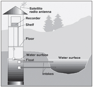
Most U.S. Geological Survey (USGS) streamgages measure stage and consist of a structure in which instruments used to measure, store, and transmit the stream-stage information are housed. Stage, sometimes called gage height, can be measured using a variety of methods. One common approach is with a stilling well in the river bank (image to the left) or attached to a bridge pier. Water from the river enters and leaves the stilling well through underwater pipes allowing the water surface in the stilling well to be at the same elevation as the water surface in the river. The stage is then measured inside the stilling well using a float or a pressure, optic, or acoustic sensor. The measured stage value is stored in an electronic data recorder on a regular interval, usually every 15 minutes.
Sources/Usage
Public Domain.