
Terms to describe the measurement of tsunamis

Detailed Description
Bathymetry—the measurement of water depth of a body of water (e.g., ocean, sea, river, bay, lake, etc.)
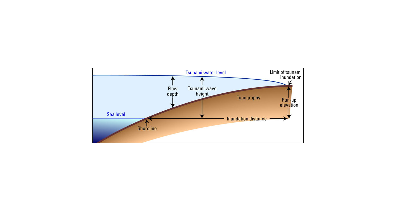
Flow depth, tsunami flow depth, direction—similar to tsunami height, tsunami wave height, or tsunami water level. Flow depth relates to the depth of the water from a tsunami, measured on shore in different locations; flow direction relates to the direction of this flow. See also Tsunami wave height, below.
Inundation, or inundation distance—The horizontal distance inland that a tsunami penetrates, generally measured perpendicularly to the shoreline.*
Inundation line—Inland limit of wetting, measured horizontally from the mean sea level (MSL) line. The line between living and dead vegetation is sometimes used as a reference. In tsunami science, the landward limit of tsunami runup.*
Morphological change—The change in form or shape of an area (e.g., the beach) involving the motion of sediment, e.g., as caused by a tsunami wave.
Paleotsunami—Tsunami occurring prior to the historical record or for which there are no written observations. Paleotsunami research is based primarily on the identification, mapping, and dating of tsunami deposits found in coastal areas, and their correlation with similar sediments found elsewhere locally, regionally, or across ocean basins. In one instance, the research has led to a new concern for the possible future occurrence of great earthquakes and tsunamis along the northwest coast of North America. In another instance, the record of tsunamis in the Kuril- Kamchatka region is being extended much further back in time. As work in this field continues it may provide a significant amount of new information about past tsunamis to aid in the assessment of the tsunami hazard.*
Reef flat—The shallow, flattest area of the reef with dead reef rock, often partly eroded and uncovered at low tide. Depths range from 0-2 meters (0-7 feet). Depending on wave action and temperatures the surface may be just featureless or a complex maze of interconnecting channels, tide pools, patches of coral debris, and sand patches. Coral growth is usually poor.
Runup or Run-up—
- Difference between the elevation of maximum tsunami penetration (inundation line) and the sea level at the time of the tsunami. In practical terms, runup is only measured where there is a clear evidence of the inundation limit on the shore.*
- Elevation reached by seawater measured relative to some stated datum such as mean sea level, mean low water, sea level at the time of the tsunami attack, etc., and measured ideally at a point that is a local maximum of the horizontal inundation. Where the elevation is not measured at the maximum of horizontal inundation this is often referred to as the inundation-height.*
Run-up elevation—The elevation above sea level of a tsunami at the limit of penetration
Topography—Graphic representation of the surface features of a place or region on a map, indicating their relative positions and elevations.
Tsunami deposit, Tsunami mud, Tsunami sand, Tsunami sediment, etc.—Sediments deposited by a tsunami. The finding of tsunami sediment deposits within the stratigraphic soil layers provides information on the occurrence of historical and paleotsunamis. The discovery of similarly-dated deposits at different locations, sometimes across ocean basins and far from the tsunami source, can be used to map and infer the distribution of tsunami inundation and impact.*
Tsunami hazard, Tsunami hazard assessment—The probability that a tsunami of a particular size will strike a particular section of coast. Documentation of tsunami hazards for a coastal community is needed to identify populations and assets at risk, and the level of that risk. This assessment requires knowledge of probable tsunami sources (such as earthquakes, landslides, and volcanic eruptions), their likelihood of occurrence, and the characteristics of tsunamis from those sources at different places along the coast. For those communities, data of earlier (historical and paleotsunamis) tsunamis may help quantify these factors. For most communities, however, only very limited or no past data exist. For these coasts, numerical models of tsunami inundation can provide estimates of areas that will be flooded in the event of a local or distant tsunamigenic earthquake or a local landslide.*
Tsunami propagation—Tsunamis travel outward in all directions from the generating area, with the direction of the main energy propagation generally being orthogonal to the direction of the earthquake fracture zone. Their speed depends on the depth of water, so that the waves undergo accelerations and decelerations in passing over an ocean bottom of varying depth. In the deep and open ocean, they travel at speeds of 500 to 1,000 km per hour (300 to 600 miles per hour). The distance between successive crests can be as much as 500 to 650 km (300 to 400 miles). However, in the open ocean, the height of the waves is generally less than a metre (three feet) even for the most destructive teletsunamis, and the waves pass unnoticed. Variations in tsunami propagation result when the propagation impulse is stronger in one direction than in others because of the orientation or dimensions of the generating area and where regional bathymetric and topographic features modify both the waveform and rate of advance. Specifically, tsunami waves undergo a process of wave refraction and reflection throughout their travel. Tsunamis are unique in that the energy extends through the entire water column from sea surface to the ocean bottom. It is this characteristic that accounts for the great amount of energy propagated by a tsunami.*
Tsunami wave height, Tsunami height, Tsunami water level—Difference between the elevation of the highest local water mark and the elevation of the sea level at the time of the tsunami. This is different from maximum runup because the water mark is often not observed at the inundation line, but maybe halfway up the side of a building or on a tree trunk.*
*From: Intergovernmental Oceanographic Commission. 2008. Tsunami Glossary, 2008.
Paris, UNESCO. IOC Technical Series, 85. (English.)
Sources/Usage
Public Domain.
Related

Tsunami Hazards, Modeling, and the Sedimentary Record

Tsunami and Earthquake Research
Related
Tsunami Hazards, Modeling, and the Sedimentary Record