
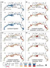
Tidal Saline Wetland migration map of the U.S. Gulf Coast
Detailed Description
This illustration shows county-level barriers and opportunities for landward migration of Tidal Saline Wetlands under alternative sea-level rise scenarios. (a) Relative percent of areas available for migration. (b to d) Relative ratio of areas where migration is prevented by current urban land (b), by future urban land (c), and by levees (d). Counties with crosshatching are expected to have less than 1 km2 of area available for migration. USGS Graphic.