
Top Ranked Topographic Change Polygon Largest Fill Area

Detailed Description
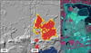
Top ranked topographic change polygon (outlined in yellow): largest fill area (9.79 km2). This mining feature is located in the Iron Range in northern Minnesota near the town of Mountain Iron. From left to right, the images are NED shaded relief, SRTM shaded relief with change polygons overlaid (blue = cut; red = fill), and Landsat image. The dates of the source data for the NED and SRTM are shown. This area is about 5.5 km east-west by 9.7 km north-south.
See the Significant Topographic Changes in the United States project for more information.
Sources/Usage
Public Domain.
Related

Ranking Features Based on Magnitude of Change
Each of the polygons in the topographic change inventory has numerous attributes associated with it. These attributes allow a ranking of features based on the magnitude of change, as measured by polygon descriptors (area and volume) and changes in terrain parameters (elevation, relief, slope, aspect). The ability to do such a ranking points out one of the advantages of producing spatially explicit...
Related
Ranking Features Based on Magnitude of Change
Each of the polygons in the topographic change inventory has numerous attributes associated with it. These attributes allow a ranking of features based on the magnitude of change, as measured by polygon descriptors (area and volume) and changes in terrain parameters (elevation, relief, slope, aspect). The ability to do such a ranking points out one of the advantages of producing spatially explicit...