
Total Water Level and Coastal Change Forecast Viewer

Detailed Description
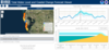
Screenshot of Total Water Level and Coastal Change Forecast Viewer on June 4, 2016, two days before Tropical Storm Colin was expected to hit Florida’s Gulf of Mexico coast. This forecast is for Treasure Island (blue balloon on map) on the day of Colin’s arrival (June 6, 2016). Top right: Expected mean (dashed line) and total (solid line) water levels for June 4 to June 9. Bottom right: expected height of water relative to height of beach dune. Map shows nearby sites where dunes were expected to erode (yellow balloons) or be overtopped by storm waves (orange balloons).
Sources/Usage
Public Domain.
Related

Operational Total Water Level and Coastal Change Forecasts
The viewer shows predictions of the timing and magnitude of water levels at the shoreline and potential impacts to coastal dunes.
Related
Operational Total Water Level and Coastal Change Forecasts
The viewer shows predictions of the timing and magnitude of water levels at the shoreline and potential impacts to coastal dunes.