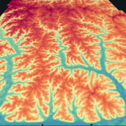
U.S. flag

An official website of the United States government

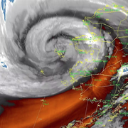
Supplemental Appropriations for Disaster Recovery Activities

USGS supports recovery efforts in declared natural disaster areas through supplemental appropriations. This site describes the USGS activities related to recovery and rebuilding after natural disasters.

When natural disasters strike our nation, Congress can appropriate funding under the Robert T. Stafford Disaster Relief and Emergency Assistance Act (42 U.S.C. 5121 et seq.) and supplemental funding acts for Federal disaster relief activities. In 201820192022, and 2023 Congress funded USGS under these Acts to aid recovery efforts from widespread wildfires, devastating hurricanes, prolonged volcanic eruptions, and damaging earthquakes. This enables USGS to repair and replace equipment and facilities, collect high-resolution elevation data, and conduct scientific studies and assessments to support recovery and rebuilding decisions. 

News

SPCMSC Team deploys instruments on Breton Island Louisiana

SPCMSC Team deploys instruments on Breton Island Louisiana

Acting Deputy Secretary of the Interior joined staff from the USGS and Puerto Rico Department of Natural and Environmental Resources for roundtable discussion and press event on climate adaptation science and partnerships at the University of Puerto Rico

Acting Deputy Secretary of the Interior joined staff from the USGS and Puerto Rico Department of Natural and Environmental Resources for roundtable discussion and press event on climate adaptation science and partnerships at the University of Puerto Rico

USGS showcased three Coastal Change Hazards tools to natural hazards resilience specialists at the Southeast and Caribbean Disaster Resilience Partnership (SCDRP) Annual Meeting

USGS showcased three Coastal Change Hazards tools to natural hazards resilience specialists at the Southeast and Caribbean Disaster Resilience Partnership (SCDRP) Annual Meeting

Publications

Evaluation of debris-flow building damage forecasts

Reliable forecasts of building damage due to debris flows may provide situational awareness and guide land and emergency management decisions. Application of debris-flow runout models to generate such forecasts requires combining hazard intensity predictions with fragility functions that link hazard intensity with building damage. In this study, we evaluated the performance of building damage fore
Authors
Katherine R. Barnhart, Christopher R. Miller, Francis K. Rengers, Jason W. Kean

Tropical or extratropical cyclones: What drives the compound flood hazard, impact, and risk for the United States Southeast Atlantic coast?

Subtropical coastlines are impacted by both tropical and extratropical cyclones. While both may lead to substantial damage to coastal communities, it is difficult to determine the contribution of tropical cyclones to coastal flooding relative to that of extratropical cyclones. We conduct a large-scale flood hazard and impact assessment across the subtropical Southeast Atlantic Coast of the United
Authors
Kees Nederhoff, Tim Leijnse, Kai Alexander Parker, Jennifer Anne Thomas, Andrea O'Neill, Maarten van Ormondt, Robert T. McCall, Li H. Erikson, Patrick L. Barnard, Amy C. Foxgrover, Wouter Klessens, Norberto C. Nadal-Caraballo, Chris Massey

The 2023 US 50-State National Seismic Hazard Model: Overview and implications

The US National Seismic Hazard Model (NSHM) was updated in 2023 for all 50 states using new science on seismicity, fault ruptures, ground motions, and probabilistic techniques to produce a standard of practice for public policy and other engineering applications (defined for return periods greater than ∼475 or less than ∼10,000 years). Changes in 2023 time-independent seismic hazard (both increase
Authors
Mark D. Petersen, Allison Shumway, Peter M. Powers, Edward H. Field, Morgan P. Moschetti, Kishor S. Jaiswal, Kevin R. Milner, Sanaz Rezaeian, Arthur Frankel, Andrea L. Llenos, Andrew J. Michael, Jason M. Altekruse, Sean Kamran Ahdi, Kyle Withers, Charles Mueller, Yuehua Zeng, Robert E. Chase, Leah M. Salditch, Nicolas Luco, Kenneth S. Rukstales, Julie A Herrick, Demi Leafar Girot, Brad T. Aagaard, Adrian Bender, Michael Blanpied, Richard W. Briggs, Oliver S. Boyd, Brandon Clayton, Christopher DuRoss, Eileen L. Evans, Peter J. Haeussler, Alexandra Elise Hatem, Kirstie Lafon Haynie, Elizabeth H. Hearn, Kaj M. Johnson, Zachary Alan Kortum, N. Simon Kwong, Andrew James Makdisi, Henry (Ben) Mason, Daniel McNamara, Devin McPhillips, P. Okubo, Morgan T. Page, Fred Pollitz, Justin Rubinstein, Bruce E. Shaw, Zheng-Kang Shen, Brian Shiro, James Andrew Smith, William J. Stephenson, Eric M. Thompson, Jessica Ann Thompson Jobe, Erin Wirth, Robert C. Witter

Science

Alaska Flood Staffs

The U.S. Geological Survey (USGS) uses observations of flooding in communities to monitor hazard conditions and support research by the USGS and its partners into a variety of hazard processes in Alaska. Local observations of flooding at a flood staffs are used to document flood elevations, improve flood models, and support floodplain management decisions.
link

Alaska Flood Staffs

The U.S. Geological Survey (USGS) uses observations of flooding in communities to monitor hazard conditions and support research by the USGS and its partners into a variety of hazard processes in Alaska. Local observations of flooding at a flood staffs are used to document flood elevations, improve flood models, and support floodplain management decisions.
Learn More

Digital Shoreline Analysis System (DSAS)

Software for calculating positional boundary change over time The Digital Shoreline Analysis System (DSAS) version 6 is a standalone application that calculates shoreline or boundary change over time. The GIS of a user’s choice is used to prepare the data for DSAS. Like previous versions, DSAS v.6 enables a user to calculate rate-of-change statistics from multiple historical shoreline positions...
link

Digital Shoreline Analysis System (DSAS)

Software for calculating positional boundary change over time The Digital Shoreline Analysis System (DSAS) version 6 is a standalone application that calculates shoreline or boundary change over time. The GIS of a user’s choice is used to prepare the data for DSAS. Like previous versions, DSAS v.6 enables a user to calculate rate-of-change statistics from multiple historical shoreline positions...
Learn More

Typhoon Merbok Disaster Emergency Recovery Efforts

Extreme storm events, such as Extratropical-Typhoon Merbok that hit the coast of Western Alaska in September 2022, are stark reminders of the devastating impacts coastal storms can have on Alaska Native community’s livelihoods and infrastructure. A chronic lack of environmental monitoring and technical assistance in rural Alaska present major barriers to communities affected by Typhoon Merbok...
link

Typhoon Merbok Disaster Emergency Recovery Efforts

Extreme storm events, such as Extratropical-Typhoon Merbok that hit the coast of Western Alaska in September 2022, are stark reminders of the devastating impacts coastal storms can have on Alaska Native community’s livelihoods and infrastructure. A chronic lack of environmental monitoring and technical assistance in rural Alaska present major barriers to communities affected by Typhoon Merbok...
Learn More
Was this page helpful?