
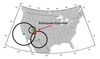
Triangulation to Locate an Earthquake

Detailed Description
Triangulation can be used to locate an earthquake. The seismometers are shown as green dots. The calculated distance from each seismometer to the earthquake is shown as a circle. The location where all the circles intersect is the location of the earthquake epicenter.
Sources/Usage
Public Domain.