
USGS Hydrologist Conducts FloaTEM Geophysical Survey on River

Detailed Description
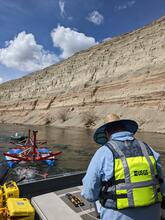
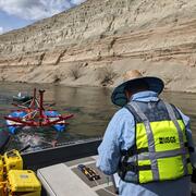
USGS Hydrologist Eric White monitors a computer displaying real-time data inversions while towing a novel floating transient electromagnetic (TEM) system (i.e., FloaTEM) on the Columbia River near Richland, Washington, adjacent to the Hanford 300 Area. The FloaTEM is being used by USGS scientists for rapid (up to 15 kilometers per hour) high-resolution electrical resistivity mapping of the subsurface below large water bodies to inform large-scale groundwater/surface water exchange modeling. The FloaTEM images to depths of approximately 50 to 80 meters below the water surface and collects a sounding every 10 to 20 meters along the profile. The FloaTEM system fills a critical gap in our ability to characterize the hydrogeology below surface-water features and supports more accurate prediction of groundwater/surface water exchange dynamics and fresh-saline groundwater interfaces.
Sources/Usage
Public Domain.
Credit: USGS/Martin Briggs
Related
Geophysics for USGS Groundwater/Surface Water Exchange Studies
Related