
USGS LSPIV and Photogrametry Drones

Detailed Description
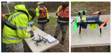
(Left) Frank Engel of the hydrologic remote sensing branch prepares the DJI Mavic Pro quadcopter , while Sean Andrews and Jeff Kinsey of the New England WSC observe. The Mavic was used for Large Scale Particle Image Velocimetry (LSPIV). High quality video was collected to determine the velocity and quantity of the water with innovative video analyzation techniques. The Mavic was also used to position other UAS using its live view. (Right) This 3DR Solo UAS mounted with a camera and computer was used to fly programmed flight paths while taking many photographs. Photos were then stitched together using Structure from Motion (SfM) Software. Satellite aerial photography available does not usually coincide with the dates of a particular site visit. This technology allows for the creation of a high resolution map quickly as well as 3d maps and digital elevation models all at the time the measurements are taken.
Sources/Usage
Public Domain.