
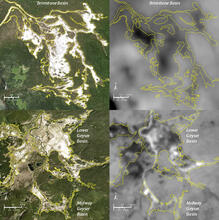
Visible/thermal maps of Brimstone Basin & Midway/Lower Geyser Basins

Detailed Description
Visible and thermal maps of Brimstone Basin (top) and Midway / Lower Geyser Basins (bottom). The images on the left are high-resolution (1-m pixels) visible images acquired by the NAIP program in 2019. In these images, the extent of the bright white surface cover is visual evidence for the thermal area, and the yellow thermal area boundaries have been digitized based on this high-resolution visual image. The images on right are Landsat 8 nighttime thermal infrared images from March 2020. In these images, bright pixels are warm and dark pixels are cool. Note that the Brimstone Basin thermal area (top) is actually colder than the surrounding forest; and that within the active Lower Geyser Basin thermal area (bottom) there are some cooler zones.
Sources/Usage
Public Domain.