
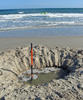
The Water Table: A hole at the beach illustrates the "water table".
By Water Science School
2011 (approx.)

Detailed Description
A hole dug at the beach is a great way to illustrate the concept of how, below a certain depth, the ground, if it is permeable enough to hold water, is saturated with water. The upper surface of this zone of saturation is called the water table. The saturated zone beneath the water table is called an aquifer, and aquifers are huge storehouses of water. What you are looking at in this picture is a "well" that exposes the water table, with an aquifer beneath it. Of course, I am cheating here, as at the beach, the level of the water table is always at the same level as the ocean, which is just below the surface of the beach.
Learn more about aquifers and the water table:
Pictures and diagrams about groundwater:
Sources/Usage
Public Domain.
Related

Aquifers and Groundwater
A huge amount of water exists in the ground below your feet, and people all over the world make great use of it. But it is only found in usable quantities in certain places underground — aquifers. Read on to understand the concepts of aquifers and how water exists in the ground.

Il ciclo dell'acqua, The Water Cycle, Italian
Il ciclo naturale dell'acqua, The Natural Water Cycle, Italian Questo diagramma mostra solo il ciclo naturale dell'acqua, ignorando le influenze umane. *English is the official language and authoritative version of all federal information
Groundwater Storage and the Water Cycle
The ground stores huge amounts of water and it exists to some degree no matter where on Earth you are. Lucky for people, in many places the water exists in quantities and at depths that wells can be drilled into the water-bearing aquifers and withdrawn to server the many needs people have.
Related
Aquifers and Groundwater
A huge amount of water exists in the ground below your feet, and people all over the world make great use of it. But it is only found in usable quantities in certain places underground — aquifers. Read on to understand the concepts of aquifers and how water exists in the ground.
Il ciclo dell'acqua, The Water Cycle, Italian
Il ciclo naturale dell'acqua, The Natural Water Cycle, Italian Questo diagramma mostra solo il ciclo naturale dell'acqua, ignorando le influenze umane. *English is the official language and authoritative version of all federal information
Groundwater Storage and the Water Cycle
The ground stores huge amounts of water and it exists to some degree no matter where on Earth you are. Lucky for people, in many places the water exists in quantities and at depths that wells can be drilled into the water-bearing aquifers and withdrawn to server the many needs people have.