
West Africa Land Cover Classes
By Earth Resources Observation and Science (EROS) Center
2013 (approx.)
Detailed Description
West Africa Land Cover Classes
Sources/Usage
Public Domain.
Related

Land Use and Land Cover Trends in West Africa
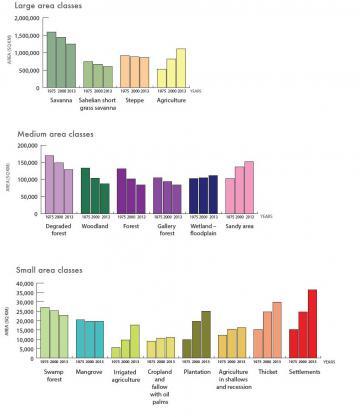
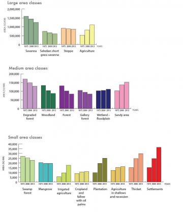
The 1975, 2000, and 2013 West Africa land use and land cover maps tell a complex story of change— a story that we are only now able to visualize for the first time. While we cannot do justice here to everything that the multi-period maps show, we can point out some of the main trends at the regional level.

Landscapes of West Africa: A Window on a Changing World
Landscapes of West Africa: A Window on a Changing World is an atlas and unique dataset that uses time-series satellite image data and field-based photography to tell the story of wide-ranging land change across 17 countries. EROS scientists selected the years 1975, 2000 and 2013 to characterize the landscapes and create the product, which represents the broadest effort to map the region in history...
Related
Land Use and Land Cover Trends in West Africa
The 1975, 2000, and 2013 West Africa land use and land cover maps tell a complex story of change— a story that we are only now able to visualize for the first time. While we cannot do justice here to everything that the multi-period maps show, we can point out some of the main trends at the regional level.
Landscapes of West Africa: A Window on a Changing World
Landscapes of West Africa: A Window on a Changing World is an atlas and unique dataset that uses time-series satellite image data and field-based photography to tell the story of wide-ranging land change across 17 countries. EROS scientists selected the years 1975, 2000 and 2013 to characterize the landscapes and create the product, which represents the broadest effort to map the region in history...