
New Features in TRAILS (web-based trail planning support application)
New functionality includes ability to incorporate user-defined custom layers to the analysis, ability to highlight potential switchback areas, inclusion of railroads in the analysis, improved project sharing, and use of the most current USGS trail data.
We are pleased to announce several improvements to the TRAILS application. You are welcome to join our monthly workshops to learn more about the new features. In addition to the improvements described below, TRAILS now uses USGS trail data dynamically. This means that as soon as there is new data in the USGS trails dataset, it will be available in the TRAILS application right away.
Adding Custom Layers into the Analysis
You are now able to add custom layers into the cost surface analysis in addition to the four predefined layers TRAILS has been using: hydrography, elevation, transportation, and PAD-US management boundaries. The example below shows how sensitive areas are included in the analysis. Connecting trail results avoid these sensitive areas because they were scored as “high cost” in the scenario settings.

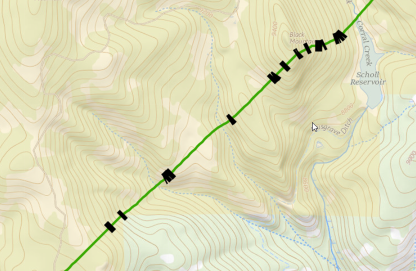
Highlighting Potential Switchback Areas
While the TRAILS application cannot currently propose actual switchback routes along steep slopes, the application is now able to highlight areas along proposed routes where the slope exceeds user-defined optimal slope range. This allows users to better understand where advanced planning will be needed.
The black rectangles in the example below highlight the sections of the trail that meet the specified slope range for potential switchback areas.
Include Railroads in the Analysis
Although railroads have always been part of the transportation analysis, you are now able to assign cost scores specifically to railroads. Expand the transportation group of features in the advance settings to access settings for Railroads.

Improved Project Sharing
In addition to the ability to either keep your project private or share your project will “everyone,” TRAILS now allows users to share their project with specific users who have access to the application. You’ll notice the new option, called “Share with specific users,” in the “Share Project” step.
