
Information by Region
Find information about your U.S. State or your Country.
Information by State/Territory
View state-specific earthquake, fault, and seismicity information and links to additional state resources.
Seismicity of the Earth Geonarratives
(Stay tuned for more listings!)
- 2025 M 7.7 Mandalay, Burma (Myanmar) Earthquake
- The 2023 Kahramanmaraş, Turkey, Earthquake Sequence
- Seismotectonics of the Eastern Margin of the Australia Plate
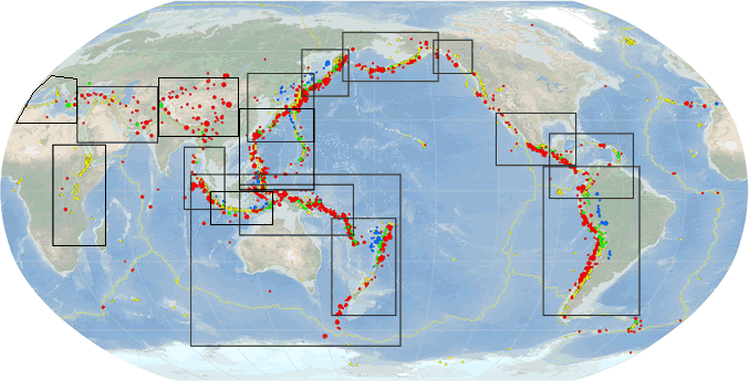
Seismicity of the Earth Maps 1900-2018
Media
Sources/Usage: Public Domain. View Media Details
Seismicity of the Earth Open File Reports:
- Seismicity of the Earth 1900–2018 (Scientific Investigations Map 3446)
- Seismicity of the Earth 1900–2007
- Seismicity of the Earth 1900–2010, Caribbean plate and vicinity
- Seismicity of the Earth 1900–2010, Aleutian arc and vicinity
- Seismicity of the Earth 1900–2007, Kuril-Kamchatka arc and vicinity
- Seismicity of the Earth 1900–2007, Japan and vicinity
- Seismicity of the Earth 1900–2013, Nazca plate and South America
- Seismicity of the Earth 1900–2010, Mexico and vicinity
- Seismicity of the Earth 1900–2010, Australia Plate and Vicinity
- Seismicity of the Earth 1900–2010, New Guinea and Vicinity
- Seismicity of the Earth 1900–2010, Eastern Margin of the Australia Plate
- Seismicity of the Earth 1900–2010, Middle East and Vicinity
- Seismicity of the Earth 1900–2010, Himalaya and Vicinity
- Seismicity of the Earth 1900–2012, Sumatra and vicinity
- Seismicity of the Earth 1900–2012, Philippine Sea Plate and Vicinity
- Seismicity of the Earth 1900–2012, Java and Vicinity
- Seismicity of the Earth 1900–2013, Offshore British Columbia-Southeastern Alaska and Vicinity
- Seismicity of the Earth 1900–2013, East African Rift
- Seismicity of the Earth 1900–2013, Mediterranean Sea and vicinity