
Hazards
Maps of earthquake shaking hazards provide information essential to creating and updating the seismic design provisions of building codes and insurance rates used in the United States. Periodic revisions of these maps incorporate the results of new research.
Workshops are conducted periodically for input into the hazards products.
Learn About Earthquake Hazards

What are the USGS National Seismic Hazard Maps and how are they used? What do I need to know about earthquake hazards? What does "earthquake hazard" mean?
Seismic Hazard Model, Maps, and Site-Specific Data

National Seismic Hazard Model (NSHM), hazard tools, and other products.
Faults in the U.S.
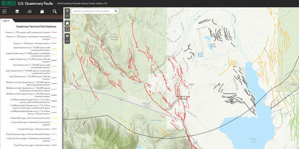
Interactive fault map ("QFaults") and information on known or suspected active faults in the United States. Also, generalized fault data used in the national seismic hazard model.

National Seismic Hazard Model Project Pages
The USGS periodically updates its National Seismic Hazard Models (NSHMs) for the United States and its territories. In addition to the individual projects, check out the NSHM Summary, Introduction, and the update history with published resources to learn about the goals, process, and results of these models.
Learn About Earthquake Hazards
What do I need to know about earthquake hazards? What does "earthquake hazard" mean? What are hazard maps?
Faults
Interactive fault map and comprehensive geologically based information on known or suspected active faults and folds in the United States. Also, generalized fault data used in the hazard model.
Seismic Hazard Model, Maps, and Site-Specific Data
U.S. Seismic Hazard Model, hazard tools, and other products.
Design Ground Motions
Ground motion parameter values for the design of buildings, bridges, and other structures.
Earthquake Scenarios
Earthquake scenarios describe the expected ground motions and effects of specific hypothetical large earthquakes.
Workshops
Workshops are announced periodically for input into the hazards products.