
2015 marks the 100th anniversary of the May 22, 1915 explosive volcanic eruption of Lassen Peak in northern California.


2015 marks the 100th anniversary of the May 22, 1915 explosive volcanic eruption of Lassen Peak in northern California. The eruption forever altered an already dynamic landscape and led to the creation of a national park, which serves as a place of discovery for curious visitors, and a living laboratory for many scientific disciplines. A century after the Lassen eruptions, work by U.S. Geological Survey scientists — in cooperation with the National Park Service — is shedding new light on these events. USGS and Lassen Volcanic National Park are commemorating the centennial with several events in 2015.
No one can say when, but it is almost certain that the Lassen area will experience volcanic eruptions again. One hundred years ago few people lived in the Lassen area; today a similar eruption would have a far more devastating effect on people’s lives and the economy of northern California.

The USGS California Volcano Observatory operates a sophisticated sensor network to detect any increase in seismicity, ground deformation, or gas emissions that could indicate magma rising toward the surface in preparation for the next Lassen eruption. Early detection of such eruption precursors is essential to effective hazard mitigation and forecasting. The work of USGS scientists at Lassen is only part of the USGS Volcano Hazards Program’s ongoing efforts to protect people’s lives and property in all of the volcanic regions of the United States.
Initial Rumblings
On May 30, 1914, Lassen Peak awoke from a 27,000-year-long slumber when it was shaken by a steam explosion. That first explosion created a small crater at the summit of Lassen Peak, and each of more than 180 subsequent steam explosions enlarged it. Over more than 11 months, these steam explosions blasted out a crater 1,000 feet across. In mid-May 1915, the character of the eruption changed dramatically. On the evening of May 14, 1915, incandescent blocks of lava could be seen bouncing down the flanks of Lassen Peak from as far away as Manton, 20 miles to the west. By the next morning, a growing lava dome had filled the crater at the summit of Lassen Peak.
Events of May 19–20, 1915
Late on the evening of May 19, a large explosion shattered the lava dome, creating a new crater at the summit of Lassen Peak. No new magma was ejected in this explosion, but glowing blocks of hot lava from the dome fell on the summit and the deeply snow-covered upper flanks of Lassen Peak—the winter of 1914–15 was the first recorded El Niño year in the western United States, and more than 30 feet of snow blanketed the upper flanks of Lassen Peak. These falling blocks of hot rock launched a half-mile-wide avalanche of snow and rock that roared 4 miles down the volcano’s steep flank and over a low ridge at Emigrant Pass into Hat Creek.
As the hot lava blocks broke into smaller fragments, the snow melted, causing the avalanche to transform into a giant mudflow of volcanic materials, called a lahar. As they came to rest, both the avalanche and lahar released huge volumes of muddy water, flooding the lower Hat Creek Valley during the early morning hours of May 20. The flood damaged several ranch houses in the Old Station area. Fortunately, the few people in these houses escaped with only minor injuries. The flood continued down Hat Creek more than 30 miles to the Pit River, where many fish were killed by the muddy water.
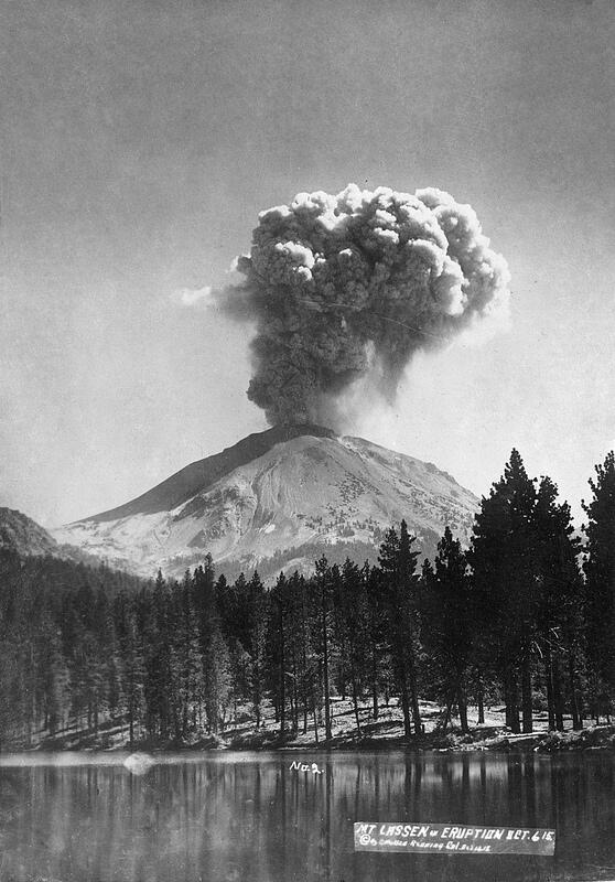
Climactic Event of May 22, 1915
After two quiet days, Lassen Peak exploded in a powerful eruption at about 4:00 in the afternoon of May 22. That blast hurled rock fragments and pumice high into the air and created the larger and deeper of the two craters seen today near the summit of the volcano. Over the next 30 minutes, a huge column of volcanic ash and gas rose more than 30,000 feet into the air—it was visible from as far away as Eureka, California, 150 miles to the west. Partial collapse of the eruption column that fell onto the northeastern slope of Lassen Peak generated a high-speed flow composed of hot ash, pumice, rock fragments, and gas—called a pyroclastic flow—that swept down the side of the volcano, devastating an area of 3 square miles. This flow rapidly incorporated and melted snow in its path. The water from the melted snow transformed the pyroclastic flow into a highly fluid lahar that followed the path of the May 19–20 lahar and rushed 15 miles down Lost Creek nearly to Old Station. This new lahar released a large volume of water that once again flooded lower Hat Creek. It also produced smaller mudflows on all flanks of Lassen Peak, deposited a layer of pumice and volcanic ash traceable for 25 miles to the northeast, and rained fine ash as far away as Elko, Nevada, 280 miles to the east.

Continued Volcanic Activity and Future Eruptions
For several years after the eruption of May 22, 1915, snowmelt percolating down into Lassen Peak, especially in the spring, triggered steam explosions, indicating that rocks beneath the volcano’s surface remained hot. Particularly vigorous steam explosions in May 1917 blasted out the northern of the two craters now seen at the volcano’s summit.
The total volume of the 1915 eruptions was tiny compared to a major eruption like that of Mount St. Helens in 1980. The deposits from the Lassen Peak eruptions are rapidly becoming obscured by vegetation and erosion, and the small size and unconsolidated nature of the thin deposits make the 1915 eruptions unlikely to be preserved in the long-term geologic record. Today, Lassen Peak sleeps again, but active steam vents, hot springs, and bubbling mudpots are still found elsewhere in Lassen Volcanic National Park.
More information:
U.S. Geological Survey California Volcano Observatory
USGS website for Lassen Volcanic Center
For more of the geologic history of the Lassen region, see these USGS Fact Sheets
Volcano hazards of the Lassen Volcanic National Park area, California
How old is “Cinder Cone”?—Solving a mystery in Lassen Volcanic National Park, California
“Hot water” in Lassen Volcanic National Park—Fumaroles, steaming ground, and boiling mudpots