
June marks National Oceans Month, a month dedicated to recognizing the natural beauty and importance of Earth’s oceans and coasts. Check out 6 cool things that USGS scientists are up to underwater and along our coasts!

Around 71 percent of the Earth’s surface is ocean, and almost half of the American population lives in coastal counties.
Each and every day, waves move sand back and forth, onto and away from beaches. The thin ribbon of sandy barrier islands and beaches along America’s coastline shifts constantly, especially during hurricanes, nor’easters and other extreme storms. Understanding these environments now and forecasting conditions into the future will help protect millions of citizens who are at risk from changing sea level, retreating shorelines and extreme coastal storms. There is also a need to balance competing demands of our ocean’s resources—from energy exploration to recreation and critical habitats—while protecting and preserving a healthy environment.
Start with Science
In order to plan, it’s vital for managers and decision makers to know what they are planning for, and USGS science underpins those choices. The USGS provides diverse science allowing for a big-picture perspective and ensuring that decisions are made with as much knowledge as possible.
6 Cool Things Scientists Are Up To
- Defining U.S. Boundaries
- Exploring Energy and Mineral Resources
- Protecting Critical Habitats
- Identifying Hazards and Vulnerable Communities
- Documenting How the Coast Changes
- Balancing Competing Demands
Defining U.S. Boundaries
International law affords every coastal nation sovereign rights over its continental shelf out to 200 nautical miles from shore. These rights include control over minerals, petroleum and sedentary organisms such as clams, crabs and coral. If certain physical criteria are met, a nation is entitled to the continental shelf beyond 200 nautical miles, an area referred to as the “extended continental shelf” or ECS. The USGS is analyzing geologic and geophysical data collected over the past 7 years to determine the nation’s ECS, and preliminary research indicates it could total one million square kilometers. The United States has an ECS in the Arctic Ocean north of Alaska, Atlantic East Coast, Bering Sea, Pacific West Coast, Gulf of Mexico and possibly other areas. The U.S. ECS Project is a collaborative effort among many agencies that are part of an Interagency Task Force, of which the USGS is a member.
Exploring Energy and Mineral Resources
America is looking to the ocean for potential resources for energy, minerals and other raw materials. Resources of high value include gas hydrates, which are a potentially significant source for natural gas. Renewable kinetic energy is another focus, such as offshore winds, tides and currents. Furthermore, deposits of rare earth elements are vital to emerging communication and information technologies, while sand and gravel deposits are important for construction and beach nourishment. USGS conducts research studies focused on geologic mapping, sampling and understanding of mineral and energy resources. In addition, USGS scientists are researching the geologic setting and processes to inform renewable energy development offshore.
Protecting Critical Habitats
Human activities can impact or degrade the health and productivity of coastal and marine ecosystems by fragmenting habitats, altering drainage or circulation patterns and introducing contaminants. USGS scientists are studying how these ecosystems function and respond to environmental changes and human impacts. For example, coral reefs act as barriers to protect coastlines from hazards, provide habitats for fisheries and support tourism and recreational industries. Since global degradation of coral reef ecosystems is prevalent, the USGS Coral Reef Ecosystem Studies Project is incorporating process studies and environmental monitoring to understand coral reef health and resilience, ultimately helping inform conservation decisions.
Identifying Hazards and Vulnerable Communities
There are several hazards that pose risks to our oceans and coasts, and USGS scientists evaluate the causes, locations and extent of such events and forecast future probabilities and occurrence.
Ongoing research includes earthquakes and underwater landslides, as well as their potential to cause a tsunami. USGS scientists provide a range of assistance regarding oil and gas spills, such as tracking the movement of residual oil, determining mortalities in wildlife, modeling how tidal waves and currents will carry oil over barrier islands and collecting samples to study toxicity to soils and water.
USGS scientists also study floods, storm surge and coastal inundation associated with hurricanes, extreme storms and sea-level rise. One essential piece of insight that the USGS brings to the table is understanding elevation. USGS scientists map how high the landscape is and how deep the ocean is to help identify coastal vulnerability to erosion, inundation and overwash. The USGS developed a rating system called the coastal vulnerability index—referred to as CVI—that identifies the possibility that physical change will occur along the shoreline as sea level rises.
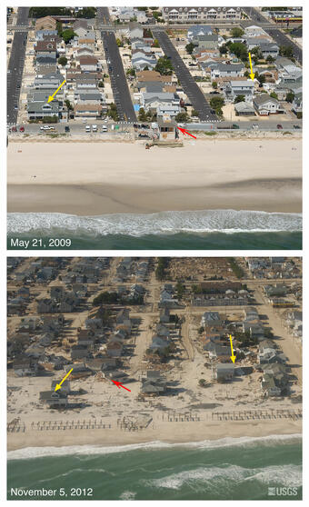
Documenting How the Coast Changes
Powerful storms generate surge, waves and currents that can move large amounts of sediment, destroy roads, buildings and other critical infrastructure as well as alter natural habitats. The USGS performs a range of studies that document, assess and model coastal change, risk and vulnerability. For example, the USGS has collected more than 140,000 aerial photographs since 1995 of the Atlantic and Gulf coasts after 24 hurricanes and other extreme storms. The USGS has also created a national map that shows past and present trends and rates through their National Assessment of Shoreline Change Project.
You can help too! A crowdsourcing application called “iCoast – Did the Coast Change?” was launched by the USGS to show coastal changes from extreme storms. Citizens can provide input and help scientists by comparing aerial photographs taken before and after storms.
Furthermore, the USGS created an online tool that allows anyone to interactively “see” past, present and future hazards and changes along the coasts. This tool—the USGS Coastal Change Hazards Portal—is an interactive mapping product with layers of information allowing you to explore your local area or the entire nation. How vulnerable is your favorite beach if a hurricane like Katrina, Ike, or Sandy paid a visit? What did your beach look like 50, 100 or 150 years ago? What might it look like in the future? Check out the Portal and find out!
Balancing Competing Demands
There are a variety of competing demands for our oceans. We play on its coasts, fish in its waters, buy and sell products transported by ships, and depend on exploration and production of energy, minerals and living resources. Marine planning is a process for identifying areas most suitable for various activities in order to avoid conflicts, facilitate compatible uses and reduce environmental impacts. There are several agencies working together to make cost-benefit decisions, with the ultimate goal of preserving the values while maximizing the benefits of the ocean.
National Ocean Policy
The National Ocean Policy (NOP) was established in 2010 in order to ensure that our oceans, coasts and Great Lakes are healthy and resilient. The NOP includes a set of priority objectives and guiding principles for policy and management actions. Support and implementation is a cooperative effort among federal agencies, states and tribes. USGS science helps address key ocean challenges and priorities outlined in the NOP.
Capitol Hill Ocean Week
Starting on June 7, hundreds of policymakers, scientists, scholars, business and conservation leaders as well as ocean enthusiasts will come together for Capitol Hill Ocean Week. The three-day symposium is hosted by the National Marine Sanctuary Foundation and aims to shape marine policy and provoke conversation about critical ocean and coastal issues. Learn more about the event and see what topics are on the agenda as well as how you can participate.