January 23, 2018 M7.9 Gulf of Alaska Earthquake and Tsunami
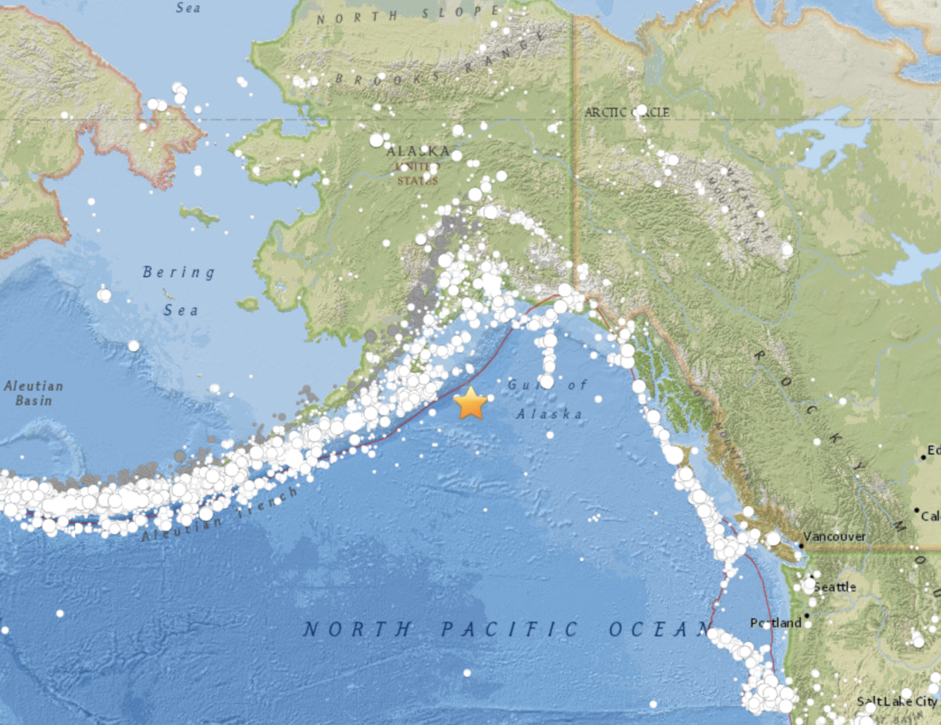
One week ago, on January 23rd at 12:31 a.m. local time, Alaskans were rocked by a magnitude 7.9 earthquake, with an epicenter in the Gulf of Alaska, about 350 miles southwest of Anchorage, and about 175 miles southeast of Kodiak Island.
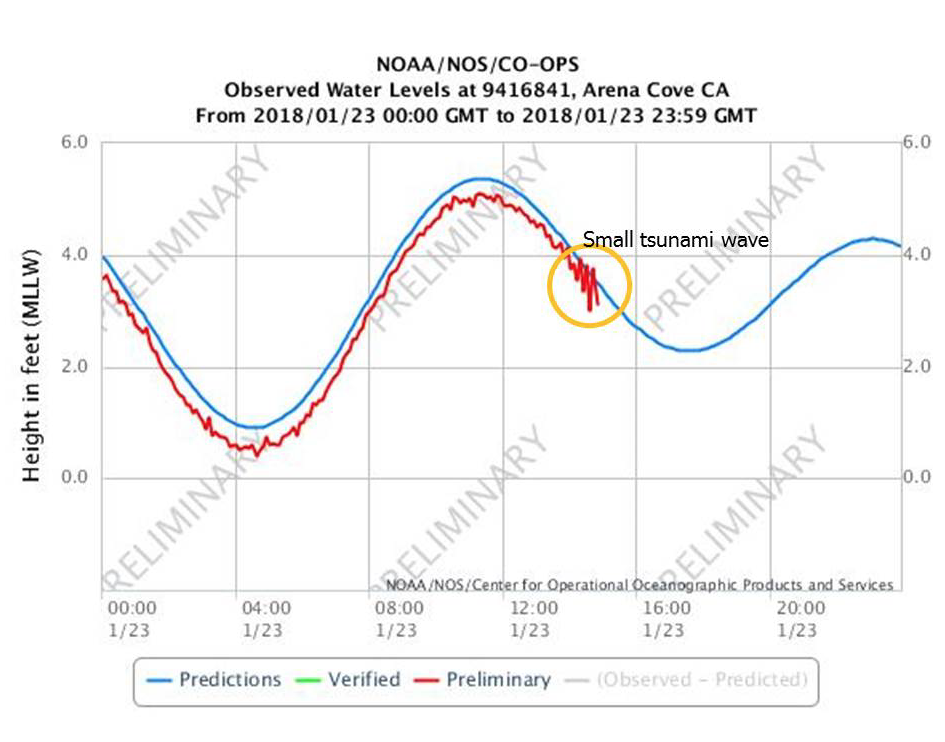
Four minutes later, Alaskans in coastal communities were awakened with blaring alarms when NOAA’s National Tsunami Warning Center sent out a Tsunami Warning for the state and the west coast of Canada based on the quake’s magnitude and its proximity to the coast. At the same time, a Tsunami Watch was issued for California, Oregon, and Washington. Ultimately, a small tsunami surge, less than one foot deep, was observed in Kodiak and smaller water-level increases occurred in other Alaskan coastal communities. A water-level rise of a few inches was detected four and a half hours later in Arena Cove, California. Three hours after the initial tsunami advisory was issued, NOAA canceled it.
Historical Large Alaskan Quakes
The first thing many people think of when they learn there has been a significant earthquake in Alaska are the infamous 20th century quakes that occurred in the Alaska-Aleutian Subduction Zone, such as the magnitude 9.2 Great Alaska Earthquake and Tsunami of 1964. Subduction zone quakes have the potential to generate very strong ground shaking, and accompanying dangerous tsunamis as occurred in 1964. After U.S. Geological Survey scientists analyzed the data recorded on the network of seismographs, they quickly realized, with some relief, that the Jan 23 event happened on a strike-slip fault, and not in the subduction zone.
The 1964 Great Alaska Earthquake generated not only a very large tsunami that traveled across the Pacific Ocean, but the strong shaking also triggered undersea landslides, resulting in deadly local tsunamis that wiped out entire coastal villages.
The January 23 Tsunami
Earthquakes in the past that have generated large tsunamis — such as the 1964 Great Alaska Earthquake and Tsunami, the 2011 M 9.1 Tohoku earthquake, and the 2004 M 9.1 Sumatra earthquake — caused significant vertical deformation of the seafloor, and thus a large amount of displaced water. The January 23 Alaska quake, however, was the result of strike-slip faulting within the shallow lithosphere of the Pacific Plate (commonly known as the Earth’s crust).
Because the January 23rd quake was generated by a strike-slip motion, only a small tsunami was generated, and the risk of a more significant tsunami was low. Strike-slip earthquakes involve horizontal motion across a fault, and do not generate significant uplift or subsidence. This means they do not, in turn, cause the significant displacement of the water column above the earthquake rupture required to generate a large tsunami.
Although strike-slip faults are less likely to cause vertical deformation of the seafloor and displace large amounts of water to generate a large tsunami, they can still be very dangerous. Any strong earthquake shaking could potentially dislodge submarine landslides and trigger a deadly local tsunami. Consequently, it was very important that the people in Kodiak, Homer spit, and parts of Seward evacuated when they received the tsunami warning, and that the police advised them to stay in place until the tsunami warning was cancelled.
What Did People Feel?
A few people on Kodiak Island felt moderate to strong shaking, but most Alaskans felt only weak to light shaking; because this earthquake occurred almost over 225 miles offshore from mainland Alaska, its impact was minimized.
For the Jan. 23 earthquake, the USGS “Prompt Assessment of Global Earthquakes for Response” (PAGER), alert level was “green,” indicating low probabilities of fatalities and low probabilities of significant economic losses. PAGER combines measurements of shaking with demographic and infrastructure information to estimate damage and loss of life probabilities.
Tectonic Setting
Near the location of the January 23 earthquake, the Pacific (tectonic) Plate is moving to the north-northwest, toward the North American Plate at a rate of approximately 59 mm/year (a little over 2 inches per year). The Pacific Plate subducts, or sinks, beneath the North American Plate at a deep-sea trench that defines the Alaska-Aleutian subduction zone on the seafloor, about 90 km (56 miles) to the northwest of the Jan. 23 earthquake epicenter. The location and mechanism of the January 23rd earthquake show it occurred on a fault system within the Pacific Plate, about 16 miles deep, rather than on the actual plate boundary between the Pacific and North American Plates further to the northwest.
Far-Away Effects of Large Earthquakes
In addition to the well-known ground shaking, tsunamis, and other hazards, large earthquakes can produce effects very far away from their source location.
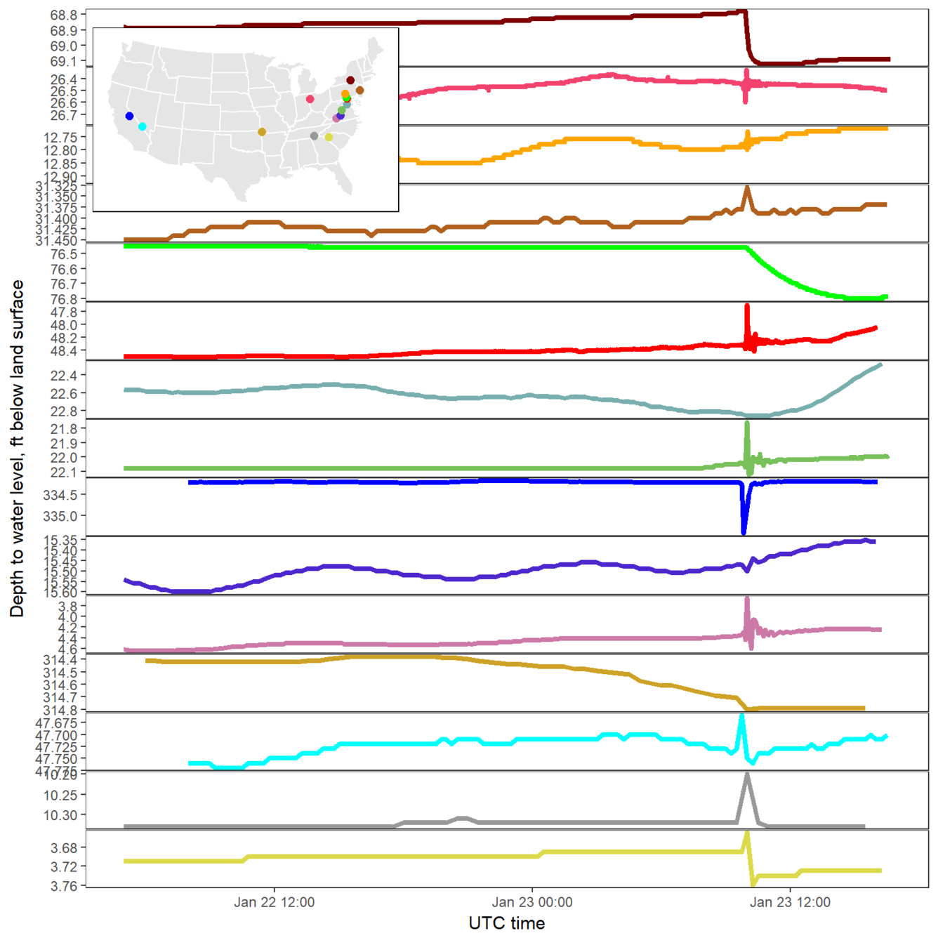
Large quakes can cause well-water levels in areas far away from the quake to either drop or rise, depending on the local geology near the well, but not all wells show this effect. Scientists are tracking these water-well changes so they can learn more about the Earth’s structure near a well, and the geophysical properties of how earthquake energy travels through the Earth’s crust.
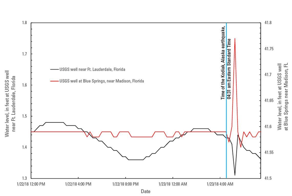
More than 3,500 miles from the Gulf of Alaska Earthquake’s epicenter, water levels at a USGS groundwater well near Madison, Florida spiked by about two inches, while levels at the USGS groundwater well near Fort Lauderdale, Florida, dropped by an inch and a half. Both recovered to their previous levels within an hour.
January 23rd was not the first time a major Alaska earthquake caused groundwater effects far from its epicenter. Water-level fluctuations caused by the magnitude 9.2 1964 Great Alaska Earthquake were recorded in 716 wells in the United States; the earthquake also was registered on water-level recorders in many other countries. The 2004 northern Sumatra Earthquake, and even the smaller 2011 Mineral, Virginia earthquake also affected groundwater level in wells far away.
Hydrogeologic responses to earthquakes have been known for decades, and have occurred both close to, and thousands of miles away from earthquake epicenters. Water wells have become turbid, dry or begun flowing, discharge of springs and ground water to streams have increased and new springs have formed, and well and surface-water quality have become degraded as a result of earthquakes.
Aftershocks
There will likely be vigorous aftershocks in the magnitude 4-5 range over the weeks and months following the January 23, 2018 earthquake, with aftershocks in the M6 range also possible, but less frequent. There is a small, but non-zero chance of the M 7.9 January 23, 2018 earthquake triggering a nearby event of comparable size or larger.


