
Reflecting on the natural hazards of 2015 serves as a reminder of the dangers we face and the need for preparedness to save lives and property.
Reflecting on the natural hazards of 2015 serves as a reminder of the dangers we face and the need for preparedness to save lives and property.
This past year, several damaging earthquakes occurred around the world, including Nepal and Chile. The nation is still experiencing widespread drought conditions. Record flooding occurred across the nation and was devastating to many. The East Coast endured high water and waves from Hurricane Joaquin and a nor’easter. Summer started with a geomagnetic storm. Almost 10 million acres were burned from wildfires in the United States last year. A few volcanoes were placed on elevated alert but volcanic activity in the nation has been fairly calm. Throughout this past winter season and now, strong El Nino conditions are expected to bring heavy precipitation to the West Coast and potential for landslides and coastal erosion.
Start with Science
While natural disasters are devastating, the USGS is dedicated to learning from past events and progressing forward with innovative research and technology to help build more robust and safer communities.
Significant Earthquakes around the World
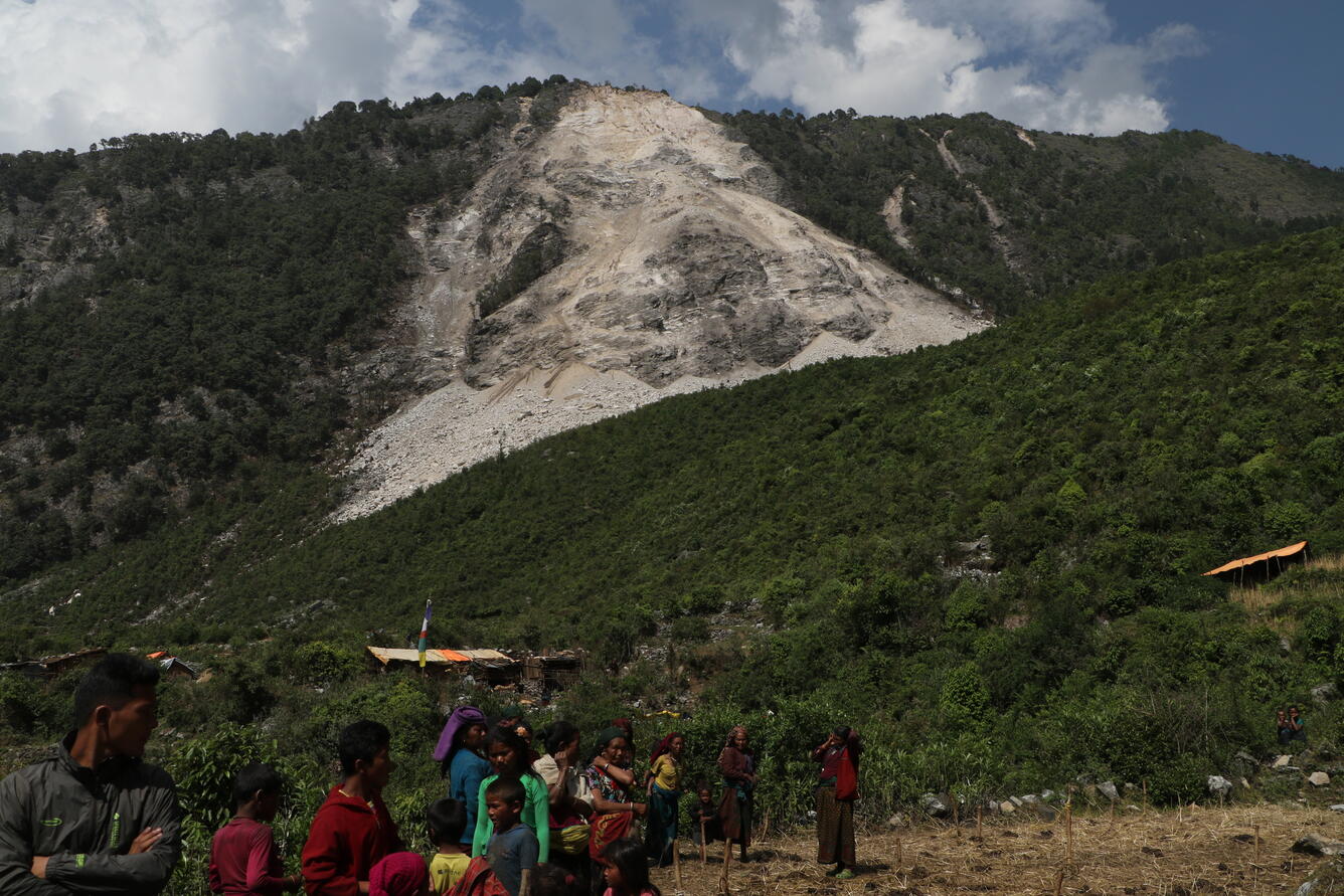
Nepal was struck by a magnitude 7.8 earthquake in April that resulted in thousands of landslides, hundreds of aftershocks and estimated damages exceeding 5 billion U.S. dollars. This series of events led to thousands of people killed, missing or injured as well as over half a million homes destroyed and widespread damage to other infrastructure. Impacts were felt as well in India, China, Pakistan and other nearby areas.
Additional noteworthy earthquakes included the magnitude 8.3 earthquake that struck Chile in September and the magnitude 7.5 earthquake in Afghanistan in October.
USGS science plays a vital role in understanding and preparing communities for earthquake hazards at home and abroad. This past year, the USGS published a study that estimates nearly half of Americans are exposed to potentially damaging earthquakes. The new estimate is nearly double the previous 2006 estimate of 75 million Americans in 39 states.
Induced Earthquakes
The rate of earthquakes in the central and eastern United States has increased sharply since 2009, with growing evidence that most of these earthquakes result from human activity, namely the injection of wastewater in deep disposal wells.
USGS scientists are dedicated to understanding human-induced earthquakes, and recent USGS studies published in 2015 include the following: an article discussing six common misconceptions about human-caused earthquakes, a new report that outlines a preliminary set of models to forecast how hazardous ground shaking could be in the areas where sharp increases in seismicity have been recorded, and a study that explores the especially high rates of activity in Oklahoma.

Unprecedented Drought
Nearly half of the nation is experiencing abnormally dry conditions, and about 2.7 percent is experiencing exceptional drought. The drought is evident instreamflow conditions as new record lows occurred throughout the west, particularly in California and also in Florida. California is currently in its fourth year of severe drought.
The USGS conducts real-time monitoring of the nation’s streams and groundwater. A current research project is focusing on documenting the severity of drought in six western states: California, Idaho, Nevada, Oregon, Utah and Washington. The goal of the study is to identify what areas are most vulnerable to future droughts. Streamflow in the region is highly seasonal, and western states depend greatly on mountain snowpack for storage of summer and fall water supplies. Snowpack in some areas have been greatly reduced as the mix in precipitation shifts from snow to rain.
Flooding Hits the Nation
Since this past December and into 2016, record flooding has occurred along rivers and streams in 12 states. The most extreme events are in Missouri, Arkansas and Illinois and have led to fatalities, hundreds of road closures and widespread power outages. Notable flooding in 2015 also occurred in the Midwest in March, the central states during the summer and the southeastern states in autumn. For each event, the USGS deployed flood monitoring teams throughout the regions, made high-flow measurements and maintained the timely delivery of streamflow data on which federal, state and local emergency response depend. USGS scientists also mapped areas of flood inundation.
For more than 100 years, the USGS has operated a nationwide streamgage network to monitor the water level and flow in the nation’s rivers and streams. The USGS works with many partners to provide essential data for flood forecasts, watches and warnings.

Double Trouble: Hurricane Joaquin and Nor’easter
The East Coast was struck this past fall by interacting dual storm systems—Hurricane Joaquin and a nor’easter moving through the Carolinas.
Projections of coastal impacts from Hurricane Joaquin issued through the USGS Coastal Change Hazards Portal provided information in a mobile-friendly format. This included forecasts on the likelihood for coastal erosion, storm surge overtopping dunes and flooding. The USGS worked closely with the National Hurricane Center, which issued up-to-date forecasts of Hurricane Joaquin’s path. In response to the nor’easter, the USGS deployed crews throughout North Carolina and South Carolina to install rapid deployment streamgages, providing more robust data to supplement the permanent, existing streamgages. The USGS also monitored landslide hazards in the area affected by the storm, assisting the North Carolina Geological Survey and the National Weather Service in providing emergency managers with information about areas of landslide potential.
Summertime Geomagnetic Storm
A severe geomagnetic storm occurred this past June, caused by the arrival at Earth of series of concentrated ejections of solar wind from the Sun. Intense magnetic storms can interfere with the operations of electric power grids and cause blackouts, as well as disturb radio communications, GPS systems, satellites and directional drilling for oil and gas.
The USGS operates a network of observatories that provide real-time data on magnetic storm conditions. USGS scientists also conduct research for situational awareness and assessment of the hazardous effects of magnetic storms. Read a newly published National Space Weather Strategy to learn about high-level priorities and goals for federal agencies to help improve the nation’s preparedness for extreme space weather.
Wildfires Sweep through the Country
Almost 10 million acres were burned from wildfires across the country last year, making it one of the largest wildfire seasons in history. The national average has been 6.7 million acres for the past 10 years, and 3.6 million acres were burned in 2014. Alaska was of particular concern last year, as over five million acres were blackened. Fire is expected occasionally in Alaska, but a growing number and frequency of large fires have occurred the past three years.
The USGS provides tools and information before, during and after fire disasters to identify wildfire risks and reduce subsequent hazards, including delivery to fire managers of up-to-the minute maps and satellite imagery about current wildfire extent and behavior. Work is also being done to understand ecosystem effects from wildfire, and this includes research on the role of climate change in this process.

Volcanic Activity
In Hawaii, Kīlauea volcano is at an ORANGE advisory level and has been active all year with scattered small breakouts of lava following a lava flow in June 2014. Mauna Loa volcano was elevated to a YELLOW advisory in September 2015 based on increased deformation and earthquake activity, with a steady rate of activity in recent months.
In Alaska, several volcano-monitoring networks were repaired this past year, greatly improving the ability to track unrest and issue advance warnings of activity. Of particular importance was new monitoring equipment at Cleveland volcano, which is one of the most active volcanoes in the Aleutian arc that frequently produces small explosions and ash plumes. By the end of 2015, YELLOW advisory alerts for Shishaldin and Cleveland volcanoes were issued, meaning they are exhibiting signs of elevated unrest. They were both downgraded from ORANGE earlier in the year. Veniaminof volcano was downgraded from YELLOW to a GREEN alert level in December.
The USGS is the agency responsible for monitoring the nation’s volcanoes. The United States has approximately 169 active volcanoes, and more than half of them could erupt explosively and threaten aviation and communities.
Continued Risk and Continued Science
These events are just a sampling of the major hazard events that occurred in 2015. There are many other issues of concern—from sinkholes to avian fluand environmental health. Without a doubt, natural hazards will continue, but with an enhanced scientific understanding and effective preparedness, the devastation and destruction can be reduced. The USGS will continue to do its part to research and monitor natural hazards in an effort to keep citizens better informed and prepared.