An official website of the United States government
Here's how you know
Official websites use .gov
A .gov website belongs to an official government organization in the United States.
Secure .gov websites use HTTPS
A lock () or https:// means you’ve safely connected to the .gov website. Share sensitive information only on official, secure websites.
Kīlauea's East Rift Zone lava flow remains active upslope from the Pahoa Marketplace area, visible at upper left, though activity has waned over the past week. The flow was very close to a firebreak road cut several months ago. The Pahoa Transfer Station is at upper right. The view is to the southeast.
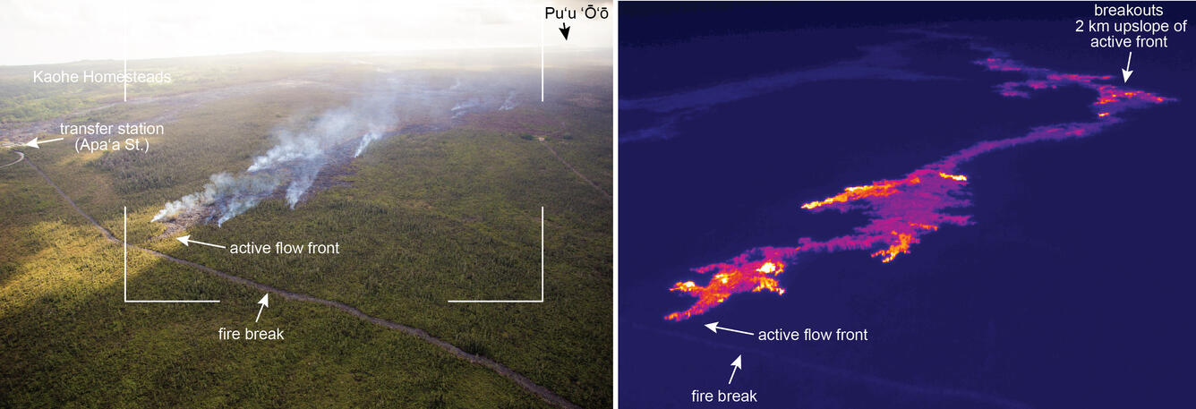
This compares a normal photograph of the active flow front with a thermal image. The white box shows the rough extent of the thermal image. In the thermal image, white and yellow pixels show areas of active breakouts. The thermal image shows that small breakouts are present near the leading tip of the flow, and that many other breakouts are active upslope.
A small, but fairly vigorous, breakout was active this afternoon about 1 km (0.6 miles) behind the tip of the flow. This is the narrowest part of the flow, with a width of about 30 m (33 yards). The smoke in the distance is from surface lava near the front of the flow. The view is to the northeast.
Breakouts were also active much farther upslope. Leaks from the lava tube near the True/Mid-Pacific geothermal well site (at left) have been active for a couple of weeks, and are slowly invading forest to the north. View is to the west-southwest.
A breakout from the lava tube has also been active on the upper part of the flow field near Pu‘u ‘Ō‘ō since December 5. The smoke is from a narrow finger of lava burning lichen on an older Pu‘u ‘Ō‘ō lava flow. Pu‘u ‘Ō‘ō is at upper right. The view is to the south-southwest.