Scientists Discover New Clues to Mount St. Helens Unusual Location
The atypical location of Mount St. Helens may be due to geologic structures that control where deep magmas can rise through the crust, as suggested by new findings published today in Nature Geoscience.
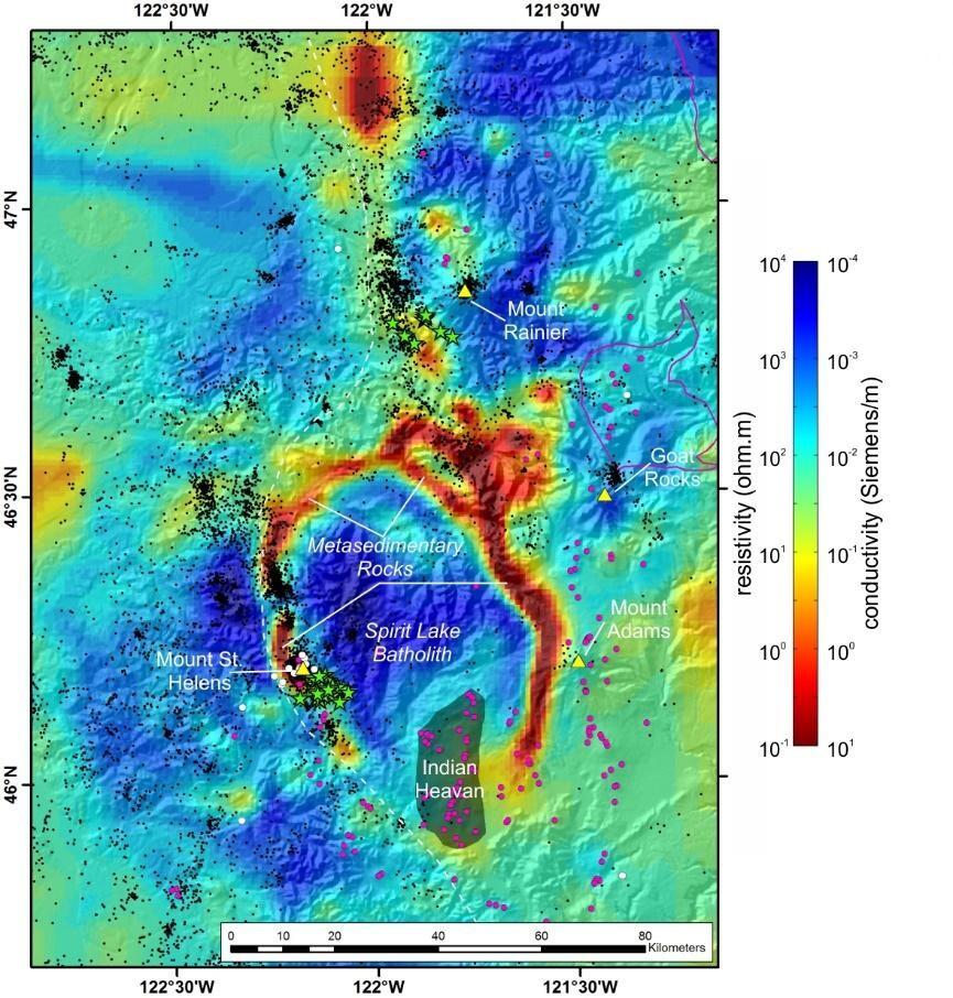
U.S. Geological Survey scientists Paul Bedrosian and Jared Peacock, along with colleagues from Oregon State University and the University of Canterbury, New Zealand, used magnetotellurics, an electromagnetic geophysical technique, to create a three-dimensional image of the crust beneath southwest Washington.
Volcanoes along the Cascade Arc stretch from British Columbia to northern California, formed by plate movement along the Cascadia subduction zone. Deep magmas are generated beneath the region in response to fluids squeezed out of the subducting plate. Although most of the magma surfaces beneath the Cascade Arc, the new findings suggest that inherited geologic structures, which are known to modify crustal stresses, can be an important factor in where magmas rise or stall within the brittle crust.

"Mount St. Helens is the most active volcano in the western United States, yet has long puzzled scientists as it sits far from the area where magma is thought to form," said Bedrosian. "This new data suggests that deep magmas exist over a broad area in the lower crust, including beneath St. Helens, but that an ancient suture acts as a crustal valve, allowing the sticky magmas characteristic of Mount St. Helens to ascend and ultimately erupt."
Since the cataclysmic eruption of May 1980, Mount St. Helens has alternated between periods of moderate activity and dormancy, punctuated most recently by the dome-building eruption from 2004 to 2008.

“This innovative study illustrates the important role of crustal structure and architecture in controlling the ascent of magma from deep storage regions," said John Pallister, geologist with the USGS Cascades Volcano Observatory. “Imaging these crustal features in the subsurface is fundamental to understanding the “where” and the “how” of volcanism. This study helps us understand why Mount St. Helens is the most active and explosive volcano in the Cascades.”
"Magma is an opportunist, exploiting crustal flaws on its way to the surface. Mapping the crustal architecture in other areas may shed light on volcanic systems that don’t fit within the standard model," said Bedrosian.
USGS provides science for a changing world. Visit USGS.gov, and follow us on Twitter @USGS and our other social media channels.
Subscribe to our news releases via e-mail, RSS or Twitter.