
A Saildrone Explorer being towed on Lake Erie at the beginning of a mission to collect data to improve fishery surveys in July 2023.
USGS and partners deploy autonomous vehicles on Lake Erie to improve fishery assessments
By Communications and Publishing
July 16, 2023
Sailing drone will circumnavigate the lake mid-July through September
ERIE, Pa. — The U.S. Geological Survey is using autonomous surface and underwater vehicles on Lake Erie from mid-July through September 2023 to improve fishery surveys across the entire lake in cooperation with several public, private, and non-profit partners in both the U.S. and Canada.
On July 14, a wind and solar-powered uncrewed surface vehicle called a Saildrone Explorer was launched on Lake Erie out of Erie, Pennsylvania. The vehicle is equipped with several environmental sensors both under and above the water, including a fisheries echosounder that uses sound to detect fish, much like a fish-finder on a fishing boat, and is operated by Saildrone, Inc. The saildrone will operate in Lake Erie’s western, central, and eastern basins, circumnavigating the lake in a clockwise direction through the end of September.
“This is the first time a long-range wind powered autonomous surface vehicle will be used on Lake Erie,” said Dr. Mark DuFour, USGS Fishery Biologist. “USGS is looking forward to working closely with Lake Erie partners on this mission to inform fishery management decisions. We encourage boaters to maintain safe distances from the saildrone to ensure that we can finish the mission.”
In addition to the saildrone, a long-range autonomous underwater vehicle (LRAUV) will be deployed near Fairport Harbor, Ohio for one week in mid-September. The LRAUV is operated by the Monterey Bay Aquarium Research Institute (MBARI) and will travel at 5-15 meters depth.
“Lake Erie is home to a world class fishery and millions of lakeside residents and vacationers," said David Nihart, Fisheries Management Chief for the Pennsylvania Fish and Boat Commission and Chair of the Lake Erie Committee, which consists of senior fisheries managers on the lake and is organized under the Great Lakes Fishery Commission. “Monitoring Lake Erie fish populations is integral to sustainable management of the recreational and commercial Lake Erie fishery, but fish community changes and dynamic habitat conditions often create monitoring challenges. We are excited to collaborate with the USGS to explore the use of autonomous vehicles for monitoring Lake Erie fish populations and fisheries.”
Media

Sources/Usage: Public Domain. View Media Details
Fisheries acoustic surveys on Lake Erie are conducted using diesel-powered research vessels that are relatively loud and, as a result, may impact data collected from near-surface and near-bottom fish. The saildrone and the LRAUV provide advantages for fishery research that may address these potential biases in existing fisheries acoustic surveys. Saildrones are quieter and may detect more fish swimming closer to the surface than noisy vessels which may scatter fish. The LRAUV, which operates in the middle of the water column and has sensors looking up and down, may detect bottom-dwelling and surface-dwelling fish more accurately than traditional fishery research vessels or the saildrone. Scientists will compare the data gathered using each platform to address potential sampling biases in existing surveys.
The partners will also use the autonomous vehicles to study a variety of other questions on Lake Erie, including the effect of harmful algal blooms on yellow perch in the western basin, detection of large species such as lake whitefish, burbot and lake trout in the eastern basin, and the effect of low-oxygen zones on bottom-dwelling fish in the central basin.
Partners on these studies include the Ohio Department of Natural Resources, Michigan Department of Natural Resources, The Ohio State University, New York State Department of Environmental Conservation, Ontario Ministry of Natural Resources and Forestry, and the Pennsylvania Fish and Boat Commission.
"These experiments using advanced technologies and autonomous vehicles are just one part of a multi-year effort by USGS and fishery management partners across the Great Lakes to improve fishery science in support of the $7 billion Great Lakes fishery," said Commissioner Jim McKane, chair of the Great Lakes Fishery Commission. "This is what 21st Century science looks like, and it's happening now here in the Great Lakes thanks to strong collaborative partnerships."
“Saildrone provides cost-effective and environmentally friendly oceanographic data collection to scientists working to protect and understand Earth’s oceans and lakes. With two years of successful data collection missions in lakes Michigan, Huron, and Superior, Saildrone is proud to continue to support USGS's data needs this year in Lake Erie and Michigan,” said Matt Womble, Sr. Director of Ocean Data Programs at Saildrone.
Notices regarding both autonomous vehicles have been provided to mariners via the U.S. Coast Guard. The acoustic technology used in the study is not hazardous to people or animals and will not interfere with sonar, communications equipment, or similar electronics. Boaters are asked to maintain a safe distance of 1500 feet from the saildrone.
Additional media assets can be found by contacting Saildrone directly at jenn.virskus@saildrone.com.
Any use of trade, firm, or product names is for descriptive purposes only and does not imply endorsement by the U.S. Government.
Media
Sources/Usage: Public Domain. View Media Details
# # #
The USGS provides science for a changing world. Learn more at www.usgs.gov or follow us on Facebook @USGeologicalSurvey, YouTube @USGS, Instagram @USGS, or Twitter @USGS.
Related

Saildrone is towed onto Lake Erie, July 2023
A Saildrone Explorer being towed on Lake Erie at the beginning of a mission to collect data to improve fishery surveys in July 2023.

Saildrone being towed through Erie, PA harbor
A Saildrone Explorer being towed in the harbor in Erie, PA at the beginning of a mission to collect data to improve fishery surveys in July 2023.
A Saildrone Explorer being towed in the harbor in Erie, PA at the beginning of a mission to collect data to improve fishery surveys in July 2023.

Saildrone is towed on Lake Erie, July 2023
A Saildrone Explorer being towed on Lake Erie at the beginning of a mission to collect data to improve fishery surveys in July 2023.
A Saildrone Explorer being towed on Lake Erie at the beginning of a mission to collect data to improve fishery surveys in July 2023.

Saildrone being towed on before launch on Lake Erie
Saildrone being towed on before launch on Lake ErieA Saildrone Explorer being towed through the harbor in Erie, PA at the beginning of a mission to collect data to improve fishery surveys in July 2023.
Saildrone being towed on before launch on Lake Erie
Saildrone being towed on before launch on Lake ErieA Saildrone Explorer being towed through the harbor in Erie, PA at the beginning of a mission to collect data to improve fishery surveys in July 2023.

Saildrone is towed into Lake Erie, July 2023
A Saildrone Explorer in the harbor being towed out onto Lake Erie for the beginning of a mission to collect data to improve fishery surveys on July 14, 2023.
A Saildrone Explorer in the harbor being towed out onto Lake Erie for the beginning of a mission to collect data to improve fishery surveys on July 14, 2023.

Saildrone being towed through the harbor in Erie, PA
Saildrone being towed through the harbor in Erie, PAA Saildrone Explorer being towed through the harbor in Erie, PA at the beginning of a mission to collect data to improve fishery surveys in July 2023.
Saildrone being towed through the harbor in Erie, PA
Saildrone being towed through the harbor in Erie, PAA Saildrone Explorer being towed through the harbor in Erie, PA at the beginning of a mission to collect data to improve fishery surveys in July 2023.

Saildrone at the dock in Erie, PA before launch
A Saildrone Explorer in the harbor before its launch on Lake Erie for the beginning of a mission to collect data to improve fishery surveys in July 2023.
A Saildrone Explorer in the harbor before its launch on Lake Erie for the beginning of a mission to collect data to improve fishery surveys in July 2023.

Saildrone being towed into Lake Erie, July 2023
A Saildrone Explorer in the harbor being towed out onto Lake Erie for the beginning of a mission to collect data to improve fishery surveys on July 14, 2023.
A Saildrone Explorer in the harbor being towed out onto Lake Erie for the beginning of a mission to collect data to improve fishery surveys on July 14, 2023.

Saildrone Deployment on Lake Erie, July 2023
This video shows a Saildrone Explorer in the harbor and being towed out onto Lake Erie for the beginning of a mission to collect data to improve fishery surveys on July 14, 2023.
This video shows a Saildrone Explorer in the harbor and being towed out onto Lake Erie for the beginning of a mission to collect data to improve fishery surveys on July 14, 2023.

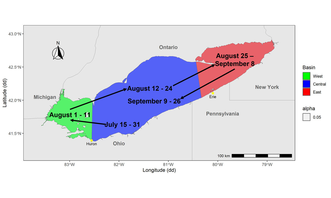
Lake Erie Saildrone Sampling Tracks for 2023
A map of Lake Erie that includes the rough dates of operation of autonomous and crewed vehicles by USGS, Saildrone, Monterey Bay Aquarium Research Institute (MBARI), and State and Ontario partners throughout Lake Erie during summer 2023.
A map of Lake Erie that includes the rough dates of operation of autonomous and crewed vehicles by USGS, Saildrone, Monterey Bay Aquarium Research Institute (MBARI), and State and Ontario partners throughout Lake Erie during summer 2023.

Tethys Visits the Great Lakes
Long-range autonomous underwater vehicle 'Tethys' upon retrieval after a 400 km mission in Lake Michigan to collect the environmental DNA (bits of DNA drifting in the environment) of pelagic prey fish through a partnership between the USGS Great Lakes Science Center and the Monterrey Bay Aquarium Research Institute. Photo Credit: Peter Esselman, USGS.
Long-range autonomous underwater vehicle 'Tethys' upon retrieval after a 400 km mission in Lake Michigan to collect the environmental DNA (bits of DNA drifting in the environment) of pelagic prey fish through a partnership between the USGS Great Lakes Science Center and the Monterrey Bay Aquarium Research Institute. Photo Credit: Peter Esselman, USGS.
Related
Saildrone is towed onto Lake Erie, July 2023
A Saildrone Explorer being towed on Lake Erie at the beginning of a mission to collect data to improve fishery surveys in July 2023.
A Saildrone Explorer being towed on Lake Erie at the beginning of a mission to collect data to improve fishery surveys in July 2023.
Saildrone being towed through Erie, PA harbor
A Saildrone Explorer being towed in the harbor in Erie, PA at the beginning of a mission to collect data to improve fishery surveys in July 2023.
A Saildrone Explorer being towed in the harbor in Erie, PA at the beginning of a mission to collect data to improve fishery surveys in July 2023.
Saildrone is towed on Lake Erie, July 2023
A Saildrone Explorer being towed on Lake Erie at the beginning of a mission to collect data to improve fishery surveys in July 2023.
A Saildrone Explorer being towed on Lake Erie at the beginning of a mission to collect data to improve fishery surveys in July 2023.
Saildrone being towed on before launch on Lake Erie
Saildrone being towed on before launch on Lake ErieA Saildrone Explorer being towed through the harbor in Erie, PA at the beginning of a mission to collect data to improve fishery surveys in July 2023.
Saildrone being towed on before launch on Lake Erie
Saildrone being towed on before launch on Lake ErieA Saildrone Explorer being towed through the harbor in Erie, PA at the beginning of a mission to collect data to improve fishery surveys in July 2023.
Saildrone is towed into Lake Erie, July 2023
A Saildrone Explorer in the harbor being towed out onto Lake Erie for the beginning of a mission to collect data to improve fishery surveys on July 14, 2023.
A Saildrone Explorer in the harbor being towed out onto Lake Erie for the beginning of a mission to collect data to improve fishery surveys on July 14, 2023.
Saildrone being towed through the harbor in Erie, PA
Saildrone being towed through the harbor in Erie, PAA Saildrone Explorer being towed through the harbor in Erie, PA at the beginning of a mission to collect data to improve fishery surveys in July 2023.
Saildrone being towed through the harbor in Erie, PA
Saildrone being towed through the harbor in Erie, PAA Saildrone Explorer being towed through the harbor in Erie, PA at the beginning of a mission to collect data to improve fishery surveys in July 2023.
Saildrone at the dock in Erie, PA before launch
A Saildrone Explorer in the harbor before its launch on Lake Erie for the beginning of a mission to collect data to improve fishery surveys in July 2023.
A Saildrone Explorer in the harbor before its launch on Lake Erie for the beginning of a mission to collect data to improve fishery surveys in July 2023.
Saildrone being towed into Lake Erie, July 2023
A Saildrone Explorer in the harbor being towed out onto Lake Erie for the beginning of a mission to collect data to improve fishery surveys on July 14, 2023.
A Saildrone Explorer in the harbor being towed out onto Lake Erie for the beginning of a mission to collect data to improve fishery surveys on July 14, 2023.
Saildrone Deployment on Lake Erie, July 2023
This video shows a Saildrone Explorer in the harbor and being towed out onto Lake Erie for the beginning of a mission to collect data to improve fishery surveys on July 14, 2023.
This video shows a Saildrone Explorer in the harbor and being towed out onto Lake Erie for the beginning of a mission to collect data to improve fishery surveys on July 14, 2023.
Lake Erie Saildrone Sampling Tracks for 2023
A map of Lake Erie that includes the rough dates of operation of autonomous and crewed vehicles by USGS, Saildrone, Monterey Bay Aquarium Research Institute (MBARI), and State and Ontario partners throughout Lake Erie during summer 2023.
A map of Lake Erie that includes the rough dates of operation of autonomous and crewed vehicles by USGS, Saildrone, Monterey Bay Aquarium Research Institute (MBARI), and State and Ontario partners throughout Lake Erie during summer 2023.
Tethys Visits the Great Lakes
Long-range autonomous underwater vehicle 'Tethys' upon retrieval after a 400 km mission in Lake Michigan to collect the environmental DNA (bits of DNA drifting in the environment) of pelagic prey fish through a partnership between the USGS Great Lakes Science Center and the Monterrey Bay Aquarium Research Institute. Photo Credit: Peter Esselman, USGS.
Long-range autonomous underwater vehicle 'Tethys' upon retrieval after a 400 km mission in Lake Michigan to collect the environmental DNA (bits of DNA drifting in the environment) of pelagic prey fish through a partnership between the USGS Great Lakes Science Center and the Monterrey Bay Aquarium Research Institute. Photo Credit: Peter Esselman, USGS.