
Volcano Watch — Kīlauea Volcano's summit water lake is one-year old
On July 25, 2019, ponded water was first observed within Halema‘uma‘u at the summit of Kīlauea Volcano. Over the past twelve months, the USGS Hawaiian Volcano Observatory (HVO) has watched this amazing body of water grow from a nascent pond into a veritable lake, the first observed within Kīlauea caldera in at least 200 years.
Volcano Watch is a weekly article and activity update written by U.S. Geological Survey Hawaiian Volcano Observatory scientists and colleagues.

HVO closely monitors the lake using a variety of methods, many of which you can check yourself on the HVO website. Visual and thermal cameras track the lake's surface color and temperature. Color is variable and the lake surface temperature is hot, consistently around 158–185 degrees Fahrenheit (70–85 Celsius). Laser rangefinder measurements track the surface level, which has risen steadily by about 2.5 ft (0.75 m) each week. And two dedicated water-sampling missions have been flown using unoccupied aircraft systems.
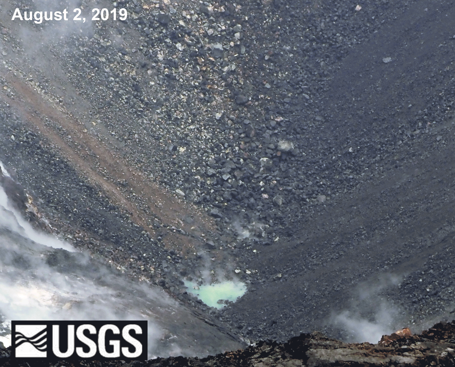
Crater lakes occur at volcanoes around the world, but very few of those crater lakes occur at basaltic volcanoes like Kīlauea. Halema‘uma‘u, which collapsed and deepened during Kīlauea's 2018 eruption, is so deep (1,600 ft/500 m) that the bottom is actually below the local water table, providing us with a unique "window" into a realm that is normally hidden from direct view.
Ground water did not rush in and fill the crater immediately because it takes time for water to squeeze through the pores and cracks of the surrounding rock, and because volcanic heat can evaporate ground water just as it does surface water. With time, the surrounding ground water slowly squeezed through the voids, and the subsurface cooled enough that water was able to remain in liquid form and accumulate within this newly exposed subaerial space. Water will continue to flow into the crater, and the lake will continue to get deeper, until a point of equilibrium is reached.
For the first few months, the source of the water was not known. Did it come from groundwater, in turn fed by rainfall? Or did it come from the condensation of water vapor released directly from magma? HVO was able to answer this question thanks to the water sampling missions. Analysis of the isotopes in the water indicated that it was meteoric in origin, meaning that it originally came from rainfall. While a small amount of rain falls directly into the crater, most of the water is coming from groundwater (that started off as rainfall that percolated into the ground) seeping in where the water table intersects the crater.
With time, minerals and volcanic gases dissolve into the water, and the lake's chemistry changes. When the lake first formed it was a light blue green in color, a color that is still seen in parts of the lake where there is higher influx. The surface water is mostly shades of orange and brown now, likely due to dissolved iron-rich sulfate minerals. The water within the lake is not uniformly mixed, and cells of water with different color, chemistry and temperature are seen to circulate.
Besides being uncommon because of its very existence, this lake is unique in that it is only mildly acidic, with a pH of ~4.0, while most volcanic lakes are either strongly acidic or strongly alkaline. For reference, orange juice is also mildly acidic with a pH of 3.5. The water's acidity is likely being moderated at this early stage of development, and it may become more acidic in the future.
Following a year of steady growth, the lake now covers an area of more than 6 acres (2.5 hectares) and reaches a depth of more than 130 ft (40 m). Its volume exceeds 125 million gallons of water, equivalent to nearly 200 Olympic-size swimming pools!
As one HVO scientist said, "We are watching a crater lake being born." As this lake continues to grow, HVO will continue to watch carefully, to learn as much as we can, and to share what we learn. A future Volcano Watch article will describe potential hazards that may result from the presence of this water lake within Kīlauea caldera.
It has been an amazing first year, "Hau‘oli Lā Hānau" (Happy Birthday) to Kīlauea Volcano's summit water lake!
Volcano Activity Update
Kīlauea Volcano is not erupting. Its USGS Volcano Alert level remains at NORMAL. Kīlauea updates are issued monthly.
Kīlauea monitoring data for the past month show variable but typical rates of seismicity and ground deformation, low rates of sulfur dioxide emissions, and only minor geologic changes since the end of eruptive activity in September 2018. The water lake at the bottom of Halema‘uma‘u continues to slowly expand and deepen. For the most current information on the lake, see https://volcanoes.usgs.gov/volcanoes/kilauea/summit_water_resources.html
Mauna Loa is not erupting and remains at Volcano Alert Level ADVISORY. This alert level does not mean that an eruption is imminent or that progression to an eruption from current level of unrest is certain. Mauna Loa updates are issued weekly.
This past week, about 105 small-magnitude earthquakes were recorded beneath the upper-elevations of Mauna Loa; most of these occurred at shallow depths of less than 8 kilometers (~5 miles). Global Positioning System (GPS) measurements show long-term slowly increasing summit inflation, consistent with magma supply to the volcano's shallow storage system. Gas concentrations and fumarole temperatures as measured at both Sulphur Cone and the summit remain stable. Webcams show no changes to the landscape. For more information on current monitoring of Mauna Loa Volcano, see: https://volcanoes.usgs.gov/volcanoes/mauna_loa/monitoring_summary.html.
There were 5 events with 3 or more felt reports in the Hawaiian Islands during the past week: a magnitude-2.7 earthquake 16 km (9 mi) SE of Waimea at 16 km (10 mi) depth on July 29 at 10:37 p.m. HST, a magnitude-2.2 earthquake 3 km (1 mi) WSW of Pāhala at 36 km (22 mi) depth on July 27 at 6:31 a.m. HST, a magnitude-4.7 earthquake 19 km (11 mi) SE of Nā‘ālehu at 36 km (22 mi) depth occurred on July 27 at 6:05 a.m. HST, a magnitude-2.6 earthquake 29 km (18 mi) E of Hōnaunau-Nāpō‘opo‘o at -1 km (0 mi) depth on July 26 at 9:10 p.m. HST, and a magnitude-2.5 earthquake 1 km (0 mi) S of Pāhala at 35 km (21 mi) depth on July 23 at 5:11 p.m. HST.
HVO continues to closely monitor both Kīlauea and Mauna Loa for any signs of increased activity.