
Volcano Watch — When were the first photographs of Kīlauea Volcano taken?
Photography continues to be a powerful tool for HVO geologists trying to tease out details of old and new eruptions at Kīlauea and other Hawaiian volcanoes.
In our January 2005 Volcano Watch article, titled "First Photograph of Kīlauea Volcano in the 60s" (http://hvo.wr.usgs.gov/volcanowatch/archive/2005/05_01_20.html), we featured an old print found in the USGS Hawaiian Volcano Observatory (HVO) photo archives. Written on the back of it was the notation, "First view of volcano in the 60s."
The photo shows Kīlauea Volcano's summit caldera and Halema‘uma‘u Crater from Uēkahuna Bluff (high point on the northwest rim of the caldera), but the landscape looks much different than the same view appears today. The geologic features shown in the image, plus the note on it, convinced us that the photo was taken in the 1860s, and that the print was the first photograph ever taken of Kīlauea.

After the article was written, we found another copy of the same print in a photo album titled "Hawaiian Views 1870s" at the Bishop Museum in Honolulu. Princess Bernice Pauahi Bishop, who gave this album to a friend, had penned a gift inscription in it dated November 23, 1878. Could this mean that the photo was taken in the 1870s instead?
During the 1870s, Kīlauea's summit caldera featured multiple domes (today called small lava shields) and lava lakes. But the old photograph does not show such features. For this reason, we still think the photo was taken in the 1860s, although we don’t know for sure.
What we do know, however, is that the note on the back of our old print was an error. The "60s" photograph was not the first to be taken of Kīlauea's summit.
In 1853, Hugo Stangenwald arrived in the Hawaiian Islands and set up a photography studio on O‘ahu. His small daguerreotype images are the oldest photographs of Hawaii that have survived.
In 1855, Stangenwald traveled to the Island of Hawai‘i, where he took a photo of Kīlauea. His scratched and faded daguerreotype of the caldera can be found in the Hawaiian Mission Houses Historic Site and Archives collection. We know the photograph was taken on his 1855 trip, because Stangenwald abandoned photography when he left the islands in 1857.
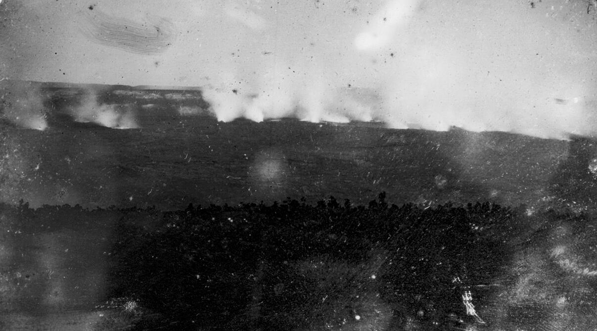
It may not look like much, but Stagenwald's old photo confirms written descriptions of a Kīlauea that is quite different from the one we know today.
Missionary Titus Coan provided an account of the caldera's appearance after a visit to Kīlauea in July 1855. He described a broad, high tableland within the caldera, with a floor that had been elevated some 600 feet (183 m) since 1840. A large dome, or shield, of about the same height rose over Halema‘uma‘u.
According to Coan, "The whole of the surrounding belt, from its periphery at the base of the great walls of Kīlauea, to the elevated central platform—and over eight miles in circumference by half a mile in diameter, is in a state of intense activity. Over this surface I could count sixty lakes of fusion whose flaming fires were sparkling, and surging, and dashing, and leaping in the most fantastic and brilliant manner, exceeding all that pen or pencil can paint."
A close examination of Stangenwald’s daguerreotype shows what appear to be many steaming vents across the floor of Kīlauea's caldera, consistent with Coan's description. The old photo, apparently taken from the present location of the Volcano House Hotel, supplies the view that Coan's pen and pencil could not—our earliest known photograph of Kīlauea Volcano's summit caldera.
Photography continues to be a powerful tool for HVO geologists trying to tease out details of old and new eruptions at Kīlauea and other Hawaiian volcanoes. These days, with the advent of digital cameras and powerful multi-spectral imaging devices that fit in the palm of your hand, the photographic record is rich beyond belief.
For a sampling of HVO's recent and archived photographs, please visit our website at http://hvo.wr.usgs.gov/multimedia/index.php.
Volcano Activity Update
Kīlauea continues to erupt at its summit and East Rift Zone. During the past week, the summit lava lake level varied between about 26 and 38 m (85—125 ft) below the vent rim within Halema‘uma‘u Crater. On the East Rift Zone, scattered lava flow activity remained within about 5.8 km (3.6 mi) northeast of Pu‘u ‘Ō‘ō and was not threatening nearby communities.
Mauna Loa is not erupting. Seismicity remains elevated above long-term background levels, but no significant changes were recorded over the past week. Deformation related to inflation of a magma reservoir beneath the summit and upper Southwest Rift Zone continues, with inflation recently occurring mainly in the southwestern part of Mauna Loa's magma storage complex.
Two earthquakes were reported felt on the Island of Hawai‘i this past week. On Tuesday, May 10, 2016, at 3:14 p.m., HST, a magnitude-3.5 earthquake occurred 8.8 km (5.4 mi) southeast of Kīlauea's summit at a depth of 3.1 km (1.9 mi). On Saturday, May 7, 2016, at 10:51 p.m., HST, a magnitude-3.1 earthquake occurred 5.4 km (3.4 mi) southeast of Kīlauea's summit at a depth of 2.1 km (1.3 mi).