
Elevation-Derived Hydrography READ Rules: Stream/River
A body of flowing water (Figure 68 and Figure 69).


Delineation
The delineation of Stream/river features shall adhere to the following rules, describing the boundary limits of the feature, and other delineation rules:
- The boundary limit of Stream/river:
- Is determined by the position of the visible edge of the banks as depicted on the DEM (as of the lidar collection date).
- Where it enters or leaves Lake/pond
- Is determined by the conformation of the land.
- Where it enters Sea/ocean
- Is determined by the location where the conformation of the land and water makes the division obvious, or, if the land and water do not suggest an obvious limit, the limit is where the stream reaches a width of 1 nautical mile (approximately 2 kilometers) without further constrictions.
- Other delineation rules
- The upper limit of Stream/river is where the feature first becomes evident as a channel.
- In cases of sharp turns of rapidly moving water, where the natural water surface is notably not level bank-to-bank, the water surface shall be represented as it exists while maintaining an aesthetic cartographic appearance.
- The entire water surface edge shall be at or below the immediately surrounding terrain.
- Stream channels shall break at culvert locations leaving the roadway over the culvert intact.
- Streams shall be continuous at bridge locations.
Representation Rules
Delineate features as points, lines, or polygons based on their area or length along different axes (Table 32).
| Kind of feature object | Area | Shortest Axis | Longest Axis |
| 0-dimensional (point) | -- | -- | -- |
| 1-dimensional (line) | -- | less than 50 ft (15 m) in Lidar; less than 98 ft (30 m) in IfSAR | -- |
| 2-dimensional (polygon) | -- | greater than 50 ft (15 m) in Lidar; greater than 98 ft (30 m) in IfSAR | -- |
Special Conditions
To accommodate variations in the shortest axis of Stream/river:
- For lidar based hydrography.
- The 3DEP breaklines used for hydroflattening streams and rivers on the elevation surface may be used as Stream/river polygon features in elevation-derived hydrography.
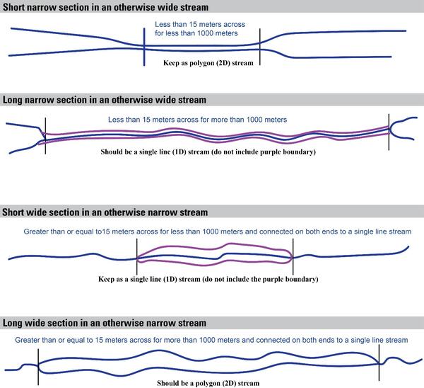
- Streams greater than 15 meters across should be delineated as (2D) polygon streams, and streams less than 15 meters across should be delineated as (1D) line streams. On occasion, the stream may narrow or expand beyond these thresholds, and the following chart explains how to adjust the stream accordingly.
- If narrowed section is less than 15 meters wide in a polygon stream for less than 1000 meters, then keep the narrowed section as a polygon feature.
- If narrowed section is less than 15 meters wide in a polygon stream for more than 1000 meters, then convert narrowed section to a line feature.
- If widened section is greater than or equal to 15 meters in a line stream for less than 1000 meters, then keep as a line stream.
- If widened section is greater than or equal to 15 meters in a line stream for more than 1000 meters, then convert widened section to a polygon feature.
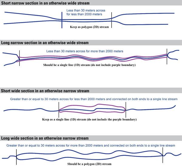
- For IfSAR based hydrography.
- Smoothed 3DEP breaklines used for hydroflattening streams and rivers on the IfSAR elevation surface may be used as Stream/river polygon features in elevation-derived hydrography.
- If narrowed section is less than 30 meters wide in a polygon stream for less than 2000 meters, then keep the narrowed section as a polygon.
- If narrowed section is less than 30 meters wide in a polygon stream for more than 2000 meters, then convert narrowed section to a line feature.
- If widened section is greater than or equal to 30 meters in a line stream for less than 2000 meters, then keep as a line stream.
- If widened section is greater than or equal to 30 meters in a line stream for more than 2000 meters, then convert widened section to a polygon feature.
- Smoothed 3DEP breaklines used for hydroflattening streams and rivers on the IfSAR elevation surface may be used as Stream/river polygon features in elevation-derived hydrography.
Data Extraction
Capture Conditions
If Stream/river" has a detectable channel on the elevation surface, then capture.,
then capture.
Attribute Information
FClass 1—Hydrography feature defined within the collection criteria of the elevation-derived hydrography specifications.
FCode 46000—Stream/river (a body of flowing water).
EClass 2— Linear feature that follows elevation surface.
OR
FClass 1—Hydrography feature defined within the collection criteria of the elevation-derived hydrography specifications.
FCode 46000—Stream/river (a body of flowing water).
EClass 11— Polygon created using a hydroflattening breakline.
OR
FClass 1—Hydrography feature defined within the collection criteria of the elevation-derived hydrography specifications.
FCode 46000—Stream/river (a body of flowing water).
EClass 12— Polygon created from edited hydroflattening breakline on flattened elevation surface.
OR
FClass 1—Hydrography feature defined within the collection criteria of the elevation-derived hydrography specifications.
FCode 46000—Stream/river (a body of flowing water).
EClass 13— Polygon created for non-flattened waterbody features in the DEM.
Source Interpretation Guidelines
See Stream/river section under the Island section of the Additional Elevation-Derived Hydrography Treatments and Elevation Specific Features for additional information about delineating islands in Stream/river polygons.