Tile Scheme Generation and CRS
Tiling schemes generated in a different projection than the lidar or DEM deliverables and reprojected into the deliverable coordinate system results in non-orthogonal tiles and clipped DEMs. This revision ensures tiling schemes will be generated in and use the same coordinate reference system as the deliverables.
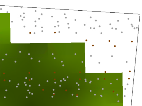
Tiling schemes have occasionally been generated in different projections (such as Albers Equal Area) that are reprojected to UTM or State Plane to match the lidar point cloud and bare-earth DEM deliverable coordinate system and projection. This leads to issues where the tiles are not orthogonal (90 degree) to the raster pixels (see illustration below). The raster DEMs end a fraction of a pixel early because they are clipping the DEM at a tile boundary that is not aligned with the pixels resulting in slight voids. The goal of this revision is to prevent that from occurring.
Current requirement:
In LBS 2022 rev. A: Data Processing and Handling: Tiles:
Tiles
- A single nonoverlapping project tiling scheme will be established and agreed upon by the data producer and the USGS–NGP before collection.
- The tiling scheme will be used for all tiled deliverables:
- The tiling scheme shall use the same coordinate reference system and units as the data.
- The tile size shall be an integer multiple of the cell size for raster deliverables.
- The tiles shall be indexed in x and y to an integer multiple of the x and y dimensions of the tile.
- The tiled deliverables shall edge-match seamlessly and without gaps.
- The tiled deliverables shall conform to the project tiling scheme without added overlap.
Change to:
(Deletions are in italic text, additions in bold text.)
Tiles
- A single nonoverlapping project tiling scheme will be established and agreed upon by the data producer and the USGS–NGP before collection.
- The tiling scheme will be used for all tiled deliverables:
- The tiling scheme shall use the same coordinate reference system and units as the data.
- The tiling scheme shall be generated in and use the same coordinate reference system and units as the lidar point cloud and raster data in order to align orthogonally to the raster pixels.
- The tile size shall be an integer multiple of the cell size for raster deliverables.
- The tiles shall be indexed in x and y to an integer multiple of the x and y dimensions of the tile.
- The tiled deliverables shall edge-match seamlessly and without gaps.
- The tiled deliverables shall conform to the project tiling scheme without added overlap.