
Island of Hawaiʻi Volcano Awareness Month Programs in January 2025!
January 2025 is the 16th annual Volcano Awareness Month on the Island of Hawai‘i! Throughout the month, the USGS Hawaiian Volcano Observatory (HVO), along with close partners, promotes the importance of understanding and respecting the volcanoes on which we live. Join us at one of the community events or enter the art and poetry contest!
Volcano Awareness Month 2025 Calendar PDF
Art & Poetry Contest Details


Wednesday, January 1
Volcano Awareness Month art and poetry contest submission opens!
You are invited to enter a USGS-Hawaiian Volcano Observatory (HVO) art and poetry contest recognizing the dynamic volcanic landscapes of Hawaiʻi nei! We welcome submissions from Kamaʻāina, visitors, and anyone with an interest in Hawaii’s volcanoes. Submit your entry by January 20, 2025. See here for more information.
Saturday, January 4
Hike the path of Mauna Loa’s 1868 lava flow
USGS Hawaiian Volcano Observatory geologist Katie Mulliken leads this guided hike along the Pu‘u o Lokuana trail, which traverses Mauna Loa’s 1868 lava flows. Katie will tell the story of the destructive earthquakes in 1868, as well as the landslides, tsunami, and Southwest Rift Zone eruption that occurred that year. During the hike, you learn about the eruptive history, structure, and current status of Mauna Loa, Earth’s largest active volcano. Katie will also share information on how HVO monitors Mauna Loa, which has erupted 34 times since 1843, most recently in 2022.
- Start time: 10:00 a.m.
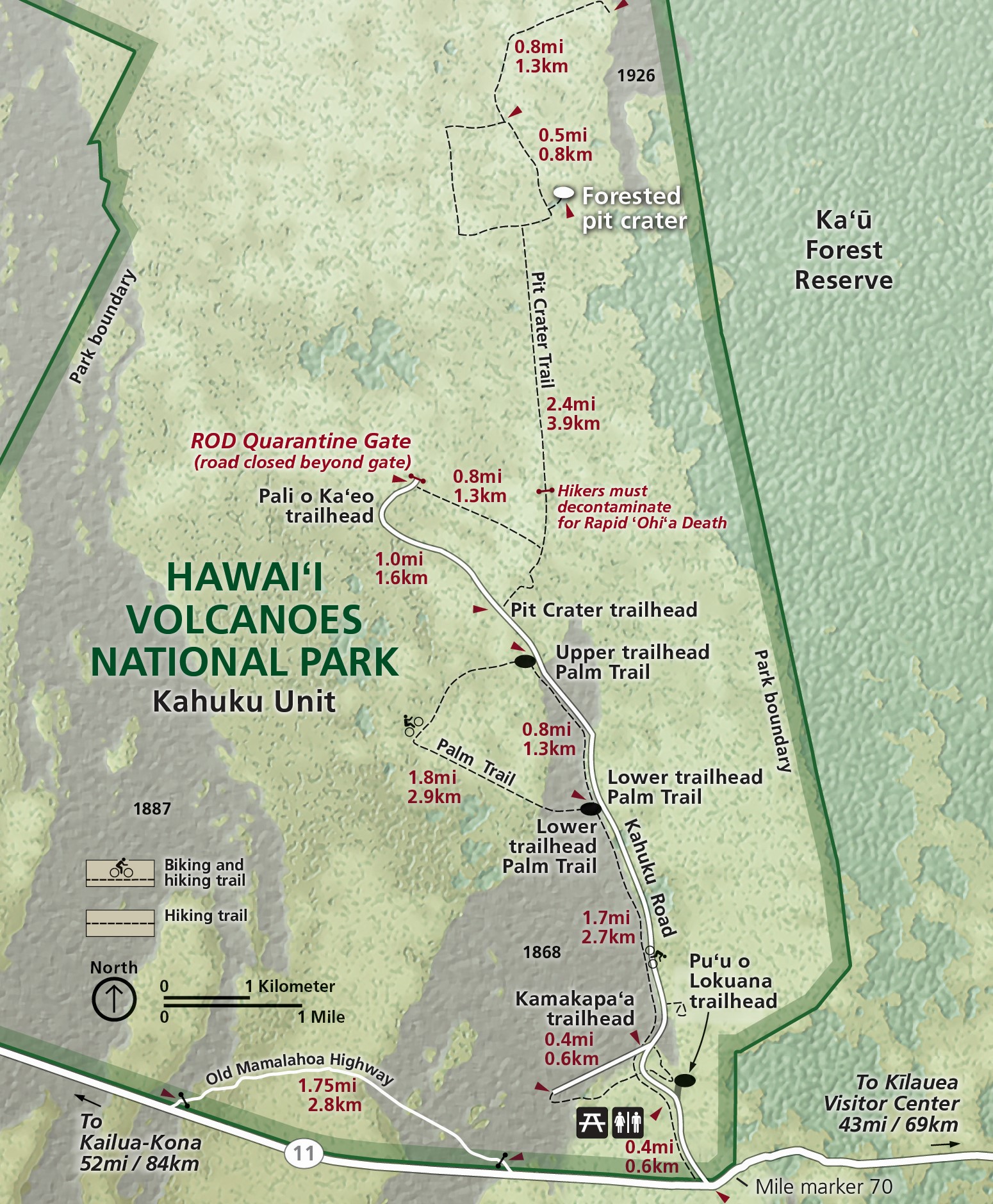
- Start/end location: Meet at the Visitor Contact Station in the Kahuku Unit of Hawaiʻi Volcanoes National Park (https://www.nps.gov/havo/images/HAVO_Kahuku-Map.jpg)
- Amenities: vault toilet at the parking lot; no running water
- Walking distance: 2 miles (3.2 km) round-trip
- Estimated duration: 2 hours
- Walk rating: easy, but includes 100-ft (30-m) elevation gain, and crosses rough, uneven lava surfaces
- For your safety: wear sturdy closed-toe walking shoes; bring protective gear for sun and rain; bring drinking water
- More info: To read more about the trail and history of Kahuku, download the NPS “Pu‘u O Lokuana Trail Guide” at: https://www.nps.gov/havo/planyourvisit/upload/Puu-o-Lokuana-Trail-Guide.pdf
Tuesday, January 7
How are volcanoes in Hawaii monitored?
The USGS Hawaiian Volcano Observatory (HVO) maintains a network of more than 200 devices across the Island of Hawaiʻi, which track activity above and below the surface of our volcanoes. Two of the most important monitoring datasets that help us understand where magma is accumulating or moving are seismicity (earthquakes) and geodesy (ground deformation). Come talk with HVO seismic network manager Jefferson Chang and geodesy network manager Andi Ellis as they host a table at Uēkahuna parking lot to showcase examples of monitoring devices and datasets. USGS photo: HVO seismic network manager Jefferson Chang establishes a station in American Samoa during the earthquake unrest there in the fall of 2022.
- Time: 10:00 a.m. – noon
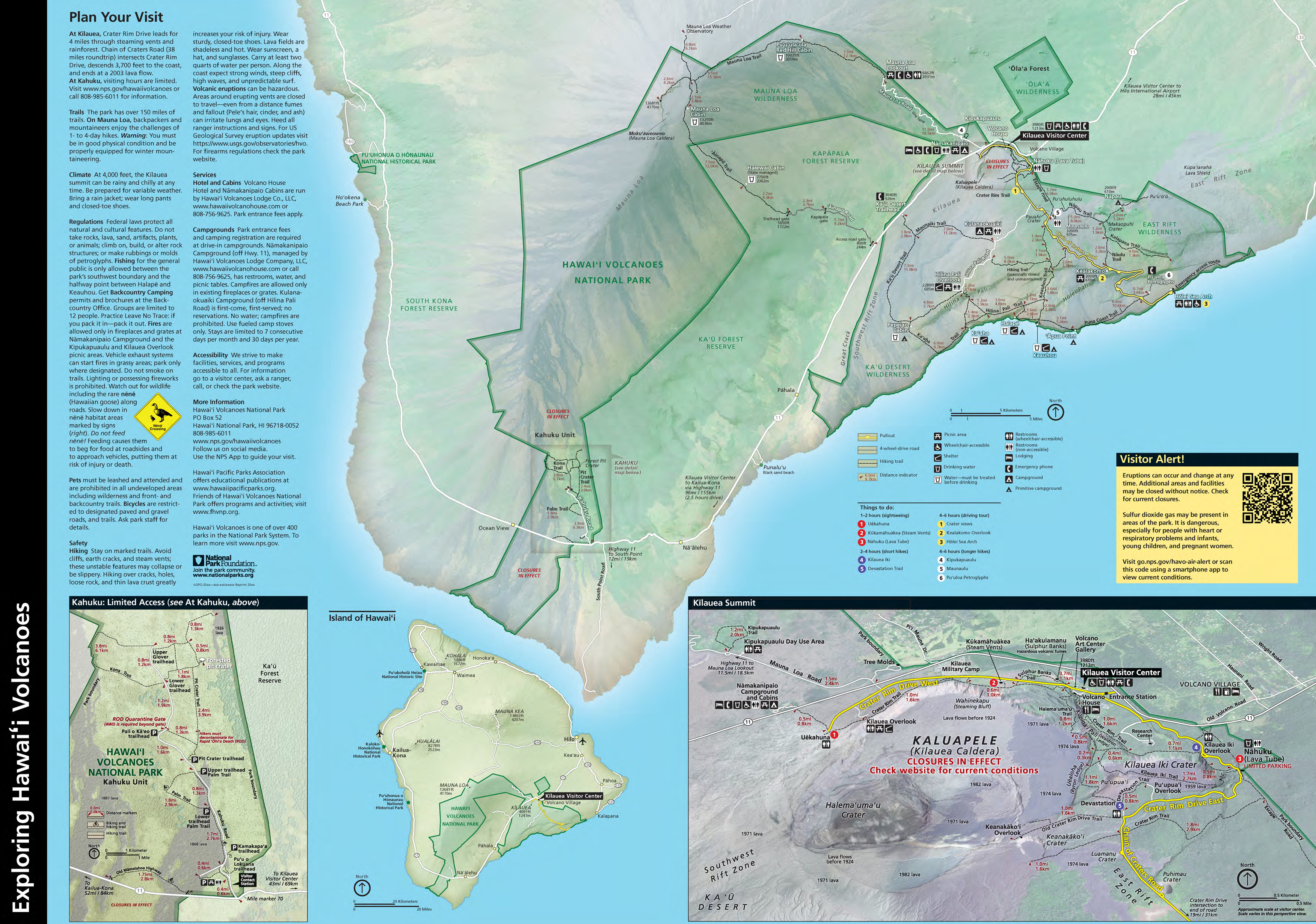
- Location: Uēkahuna overlook in Hawaiʻi Volcanoes National Park (https://www.nps.gov/havo/planyourvisit/images/HAVO_S2_2022.png)
Wednesday, January 8
Hawaiian Volcano Observatory Talk Story
Come talk story with USGS Hawaiian Volcano Observatory chief field engineer Kevan Kamibayashi as he hosts a table from 1:00–4:00 p.m. at the Nāʻālehu Public Library. Do you have questions about recent eruptions in Hawaii, volcanic hazards, how eruptions are monitored, or what it’s like working for a volcano observatory? Kevan, who has worked for the Hawaiian Volcano Observatory for over 25 years, will be available to answer those questions and more. Come talk story, browse resources, and learn more about the volcanoes in your backyard.
- Time: 1–4 p.m.
- Location: Nāʻālehu Public Library (Map: https://www.librarieshawaii.org/branch/naalehu-public-library/)
Friday, January 10
A Dynamic Year at Kīlauea
During 2024, eruptive activity at Kīlauea moved outside of Kaluapele (Kīlauea summit caldera) for the first time since 2020. Magma migrated to the southwest and southeast of the caldera during several intrusive events accompanied by hundreds of earthquakes felt by residents in nearby communities, as well as substantial ground deformation. These events culminated in a one-day eruption southwest of the caldera on June 3 and an eruption on the middle East Rift Zone, within Hawaiʻi Volcanoes National Park, from September 10–15. Join Matt Patrick, geologist at the Hawaiian Volcano Observatory, at the Cooper Center in Volcano Village, as describes this dynamic past year of activity at Kīlauea, followed by a summary of the current status of Kīlauea and a description of what might be coming next. USGS photo: A fissure erupting from the middle East Rift Zone during the September 15–20, 2024, eruption.
- Start time: 6 p.m.
- Location: Cooper Center, 19-4030 Wright Road, Volcano (https://www.thecoopercenter.org/)
Saturday, January 11
What have we learned about Kīlauea’s summit water lake?
Kīlauea’s summit collapsed in 2018, as lava erupted at lower elevations from the East Rift Zone. In late July 2019, a water lake, unprecedented in the written record of Kīlauea’s history, appeared at the bottom of the deepest part of the caldera, in Halema‘uma‘u crater. The lake steadily rose, with temperatures above boiling and changing colors, until its demise at the start of an eruption in Halemauʻmaʻu the night of December 20, 2020. The water lake was quickly replaced with a lava lake as eruptive activity returned to Kīlauea’s summit for the first time since 2018. What were the potential hazards associated with the water lake at Kīlauea’s summit? What did we learn about the water in the lake? How was it sampled and monitored? Join USGS Hawaiian Volcano Observatory geologist Tricia Nadeau, who is also an Unoccupied Aircraft Systems (UAS or drone) pilot, as she answers these questions and more. USGS photo: The water lake at the base of Halemaʻumaʻu, at the summit of Kīlauea, in January 2020.
- Start time: 9:30 a.m.
- Location: Visitor Contact Station in the Kahuku Unit of Hawaiʻi Volcanoes National Park (https://www.nps.gov/havo/images/HAVO_Kahuku-Map.jpg)
Monday, January 13
Kīlauea East Rift Zone update and talk story
In 2024, Kīlauea eruptive activity shifted out of the caldera for the first time since 2018. Eruptions occured southwest and southeast of the caldera. An eruption in and near Nāpau Crater occurred from September 15–20, 2024, near the long-lived Puʻuʻōʻō vent that erupted 1983–2018 within Hawaiʻi Volcanoes National Park. This eruption is the first from the East Rift Zone of Kīlauea since the devastating 2018 lower East Rift Zone eruption. Join USGS Hawaiian Volcano Observatory scientists Ingrid Johanson and Heather Winslow at 5 p.m. as they summarize recent activity at Kīlauea, the long-term geologic history of the East Rift Zone, and what could happen next in an approximately 45-minute presentation. They will be at the Pahoa Library for the following hour to answer questions about recent eruptions in Hawaii, volcanic hazards, how eruptions are monitored, or what it’s like working for a volcano observatory. Come talk story, browse resources, and learn more about the volcanoes in your backyard. USGS photo: Lava erupting from a fissure west of Nāpau Crater cascades down into the crater during the September 15–20 eruption on the middle East Rift Zone of Kīlauea.
- Time: presentation beings at 5 p.m.; talk story from 6–7 p.m.
- Location: Pahoa Public Library (https://www.librarieshawaii.org/branch/pahoa-public-and-school-library/)
Tuesday, January 14
Kīlauea’s Changing Summit
Kīlauea’s 2018 eruption saw the largest collapse of the volcano’s summit caldera, Kaluapele, in the past 200 years. In 2019–2020 the collapse pit hosted a water lake, which was replaced by lava in December 2020 during the first of a three-year series of caldera-filling eruptions. In 2024, eruptive activity returned to Kīlauea’s rift zones for the first time since 2018. Join Mike Zoeller, geologist with the Hawaiian Volcano Observatory, as he describes how this sequence of events provides a snapshot into the volcano’s long-term history and the morphology of present-day landforms within Kaluapele. Mike will also provide a summary of the current status of Kīlauea and discuss what might be coming next for the volcano. USGS photo: Kīlauea summit erupting in September 2023.
- Start time: 10 a.m.
- Location: Uēkahuna overlook in Hawaiʻi Volcanoes National Park (https://www.nps.gov/havo/planyourvisit/images/HAVO_S2_2022.png)
Wednesday, January 15
A Dynamic Year at Kīlauea
Following the caldera collapse in 2018, activity at Kīlauea has been dynamic. In 2019, the summit caldera (Kaluapele) featured a water lake and five eruptions in the caldera between 2020-2023 lasted from about two weeks to over a year in duration. During 2024, activity moved outside of Kaluapele for the first time since 2018. Magma moved underground during several intrusions into the Southwest Rift Zone (SWRZ) that started in October 2023 and eventually culminated in a 6-hour long eruption from the SWRZ on June 3rd, 2024. A similar pattern of pre-eruptive intrusions in the East Rift Zone preceded the week-long September 2024 eruption near Nāpau Crater on the middle East Rift Zone within Hawaiʻi Volcanoes National Park. Join Lis Gallant, Geology Department professor at the University of Hawaiʻi at Hilo, as she describes the shift from longer to shorter Kīlauea summit eruptions, the subsequent activity in the rifts, and how these events bring new questions about changes to the magma plumbing system beneath Kīlauea since 2018. USGS photo: Fissures erupt at the base of Nāpau Crater during the September 15–20, 2024, eruption on the middle East Rift Zone of Kīlauea.
- Start time: 7 p.m.
- Location: University of Hawaiʻi at Hilo, University Classroom Building (Bldg 301), Room 100 (https://www.hilo.hawaii.edu/uhh/maps.php)
Thursday, January 16
The Art and Science of Geologic Mapping
Have you ever looked at a geologic map and wondered how the different colors are determined and what they mean? Geologic mapping has been one of the most fundamental mandates of the U.S. Geological Survey (USGS) since its establishment in 1879. USGS Hawaiian Volcano Observatory geologic mapping on the Island of Hawaiʻi focuses on volcanic vents (such as fissures and scoria cones) and their associated lava flows and tephra deposits divided by age. Geologists use different criteria to tell these deposits apart, requiring countless hours of field work and lab analyses, and the deposits are represented on geologic maps by different colors. Join Drew Downs, geologist at the USGS Hawaiian Volcano Observatory, as he describes the art and science that goes into creating a geologic map for the USGS. (This presentation will be repeated at UH-Hilo on January 29.) USGS map: Geologic map units of lower Puna District, Island of Hawaiʻi.
- Start time: 6 p.m.
- Location: Volcano Art Center Niaulani Campus Dieterich Varez Hall, 19-4074 Old Volcano Road, Volcano, 96785
Saturday, January 18
Explore the Kaʻū Desert Trail
Traverse Mauna Loa’s Keamoku ʻaʻā lava flow and find the footprints in Kīlauea’s 1790 explosive ash deposit during this guided hike to the Footprints shelter in Hawai‘i Volcanoes National Park. University of Hawaiʻi at Hilo Geology Department faculty and geologist Cheryl Gansecki will talk about the geologic features along the trail in this unique region where Mauna Loa, Earth’s largest active volcano, and Kīlauea, one of Earth’s most active volcanoes, meet. Gansecki will tell the story of the fatal explosive eruption of Kīlauea in 1790, which deposited ash that preserves footprints of that time period. Adventurous hikers can continue on to Maunaiki to explore vents and lava flows of the 1919–20 eruption (adds an additional moderate hike of +2 miles roundtrip). USGS photo: The shield that formed Maunaiki during the 1919–1920 eruption.
- Start time: 10:00 a.m.
- Start/end location: Meet at the Kaʻū Desert Trailhead on Highway 11 in Hawaiʻi Volcanoes National Park (https://www.nps.gov/havo/planyourvisit/images/HAVO_S2_2022.png)
- Amenities: none
- Walking distance: approximately 2 miles (3.2 km) round-trip, optional additional 2 miles (3.2 km) round trip to Maunaiki
- Estimated duration: 2 hours
- Walk rating: easy, but includes 100-ft (30-m) elevation gain, and crosses rough, uneven lava surfaces
- For your safety: wear sturdy closed-toe walking shoes; bring protective gear for sun and rain; bring drinking water
- More info: To read more about the trail and history Footprints area, see: https://www.nps.gov/havo/planyourvisit/footprints.htm
Monday, January 20
Volcano Awareness Month art and poetry contest submission deadline!
Submissions for the USGS-Hawaiian Volcano Observatory (HVO) art and poetry contest, recognizing the dynamic volcanic landscapes of Hawaiʻi nei, are due by January 20! We welcome submissions from Kamaʻaina, visitors, anyone with an interest in Hawaii’s volcanoes. See here for more information.
Tuesday, January 21
Visit the Whitney Vault at Volcano House
The Whitney Seismological Laboratory was established in 1912, the year that Dr. Thomas Jaggar founded the Hawaiian Volcano Observatory (HVO). Constructed as the basement of the original HVO building, it followed plans provided by Professor Fusakichi Omori, who invented the Omori Seismometer to detect earthquakes. Instruments in the Whitney Vault, some of which remain preserved there today, were the first record earthquakes in Hawaii. The Whitney Vault is the only remnant of the original HVO structures, but HVO’s volcano monitoring network has grown to more than 200 instruments located across the Island of Hawaiʻi. With frequent eruptions and earthquakes in Hawaii, HVO is at the forefront of developing and testing new tools to monitor earthquakes, ground deformation, volcanic gas emissions, gravity, volcanic plumes and lava flows. Join USGS Hawaiian Volcano Observatory geophysicists Ingrid Johanson and Ashton Flinders as they describe the history of HVO volcano monitoring, showcasing old and new technologies in the Whitney Vault, located beneath the ground near the present-day Volcano House Hotel. USGS photo: A present-day view inside the Whitney Vault; the tall green items are the Omori Seismometers.
- Note: This program is limited to 20 participants. Tickets will be available first come first serve at 9 a.m. on January 21, at the Hawaiʻi Volcanoes National Park temporary visitor center, located in the Kīlauea Military Camp Koa room (99-252 Crater Rim Drive, Hawaiʻi Volcanoes National Park, 96718)
- Start time: 10 a.m.
- Location: Volcano House Hotel caldera overlook (https://www.nps.gov/havo/planyourvisit/images/HAVO_S2_2022.png)
Wednesday, January 22
Earthquakes and Eruptions in Hawaii over the past year and talk story
Did you know that earthquake hazard in the State of Hawaii is among the highest in the United States? During this past year alone, there were three earthquakes larger than 4.5 that were felt widely throughout the Hawaiian Islands: a magnitude-4.8 on November 5, a magnitude-4.7 on August 22, and a magnitude-5.9 on February 9. Hawaii also experiences frequent volcanic eruptions, including two during the past year at Kīlauea volcano. Joins USGS Hawaiian Volcano Observatory Scientist-in-Charge Ken Hon, as he summarize earthquakes and eruptions over the past year in Hawaii, highlighting hazards that can impact you and how you can participate in citizen science. Hon will host a table for an hour before the presentation, and be available to answer questions. Come talk story, browse resources, and learn more about the volcanoes in your backyard. USGS figure: image showing felt reports and shaking intensity for the magnitude-5.9 earthquake on February 9, 2024, felt across the Hawaiian Islands.
- Start time: program starts at 10 a.m.; talk story from 11 a.m.–12 p.m.
- Location: Kailua-Kona Public Library, 75-138 Hualalai Rd, Kailua Kona, HI 96740 (https://www.librarieshawaii.org/branch/kailua-kona-public-library/)
Thursday, January 23
What happened on Mauna Loa in 1868?
In 1868, the Island of Hawaiʻi experienced earthquakes, a tsunami, landslides, and a Mauna Loa Southwest Rift Zone eruption, all during about two weeks. The largest earthquake in the sequence included the largest earthquake to have occurred in Hawaii in the past two centuries, an estimated magnitude 7.9. Join USGS Hawaiian Volcano Observatory geologist Katie Mulliken as she tells the story of this destructive sequence of events in 1868. She will also share information on the eruptive history and current status of Mauna Loa, which has erupted 34 times since 1843, most recently in 2022. USGS photo: 1954 USGS aerial photo showing the 1868 Mauna Loa lava flows (dark black) that flowed along the Kahuku Pali before entering the ocean.
- Start time: 5:30 p.m.
- Location: Puʻuhonua o Hōnaunau National Historic Park amphitheater, State highway 106, Hōnaunau, 96726 (https://www.nps.gov/puho/planyourvisit/maps.htm)
- Park entrance fees may apply.
Friday, January 24
Geology Club Open House
The University of Hawaiʻi at Hilo (UH-Hilo) Geology Club invites you to a UH-Hilo Geology Department Open House! Here on the Island of Hawaiʻi, our volcanoes typically erupt basaltic rocks, but the Geology Department has a variety of rocks and minerals from around the world. Come see exotic rocks and minerals from Antarctica, Africa, and beyond. Bring along any neat rocks you have for UH-Hilo geologists to identify. Learn how the UH-Hilo Geology Department collaborates with the USGS Hawaiian Volcano Observatory (HVO) during eruptions in Hawaii, to rapidly process freshly collected lava samples and analyze them using the Energy Dispersive X-Ray Fluorescence Spectrometer (EDXRF). This near-real time EDXRF geochemical data allows HVO and UH-Hilo geologists to track changes in lava chemistry, which can inform us about magma storage processes and eruptive hazards. UH-Hilo photo: A UH-Hilo undergraduate research assistant places a sample of the September 2023 Kīlauea summit eruption into the shatterbox, which will turn the sample into a homogenous powder that can be analyzed.
- Time: 4–6 p.m.
- Location: University of Hawaiʻi at Hilo Geology Department (closest parking on West Lanikaula Street, directly across from YMCA—300 West Lanikaula Street) (https://www.hilo.hawaii.edu/uhh/maps.php)
Saturday, January 25
Trachyte Trek on Hualālai
Join HVO geologist Natalia Deligne and University of Hawaiʻi at Hilo geology department associate Rick Hazlett (author of most recent Roadside Geology of Hawaii book) as they lead a 4-mile round trip 3-hour guided walk along the ʻŌhiʻa Trail on the flank of Hualālai volcano to the base of Puʻuwaʻawaʻa cone in the Puʻuwaʻawaʻa Forest Reserve. Here, we will see some of Hualālai's oldest and most unusual rocks, trachytes formed around 100,000 years ago, including rare pumice and obsidian deposits. On the way, we will discuss Hualālai volcano, eruptions at Hualālai in the past 1,000 years, and the unrest of 1929 that included an intense earthquake swarm. Adventurous hikers can continue on to the summit along the Puʻuwaʻawaʻa Cone Trail, although this is not part of the guided hike (adds an additional 4 miles and 1000 ft elevation gain). USGS photo: people gather for a program near the base of Puʻuwaʻawaʻa cone on Hualālai volcano.
- Start time: 10 a.m.
- Start/end location: Puʻuwaʻaʻwaʻa Forest Reserve, between the 21 and 22 mile markers along Highway 190; enter through the automatic gate and keep left, drive up the road about 50 1/3 mile to find a parking area on the right, near the Puʻuwaʻawaʻa Hunter Check-in Station (https://hawaiitrails.ehawaii.gov/trails/#/trail/hia-trail/301)
- Amenities: none
- Walking distance: approximately 4 miles (6.4 km) round-trip
- Estimated duration: 3 hours
- Walk rating: moderate, but includes 800-ft (244-m) elevation gain, and crosses rough, uneven surfaces
- For your safety: wear sturdy closed-toe walking shoes; bring protective gear for sun and rain; bring drinking water
- More info: To read more about Puʻuwaʻawaʻa Forest Reserve, see: https://dlnr.hawaii.gov/forestry/frs/reserves/hawaii-island/puuwaawaa/
Monday, January 27
Update on Pāhala Earthquakes
Earthquakes have continued to occur frequently in the region 12–25 miles below the town of Pāhala since 2019, including a magnitude-4.8 on November 5, 2024, and a magnitude 5.9 on February 2, 2024. Many of these earthquakes are felt by residents of Kaʻū, with the larger events felt throughout the Island of Hawaiʻi and as far away as Oʻahu. Scientists at the USGS Hawaiian Volcano Observatory worked with members of the community to deploy nearly 100 temporary earthquake-detecting devices in the Pāhala area in 2022 in an effort learn more about what is causing these events. Join USGS Hawaiian Volcano Observatory earthquake specialist Ninfa Bennington and researcher Kiara Daly as they describe this ongoing earthquake activity and explain preliminary results of their work to better understand how these deep earthquakes relate to magma movement from the hot spot and into our active volcanoes. USGS photo: HVO earthquake specialist Ninfa Bennington deploys a small portable seismic node to detect earthquakes.
- Start time: 5:30 p.m.
- Location: Kaʻū District Gym Recreation Room, 96-1219 Kamani St., Pāhala (https://www.parks.hawaiicounty.gov/divisions/recreation/recreation-programs-and-sites-2042)
Tuesday, January 28
Kīlauea’s Explosive Past
Kīlauea is known for erupting lava flows, but there have also been explosive events in its past. Explosive deposits from events during the past several centuries are visible along the Crater Rim Trail, on the edge of Kīlauea caldera. Join USGS Hawaiian Volcano Observatory geologist Kendra J. Lynn, on a short walk along the caldera rim between Uēkahuna and Kīlauea overlooks, where you will learn about these deposits. Kendra will talk about her work investigating the magma storage conditions leading to these explosive events, which will help us to better undestand what could cause such explosive events to happen in the future. USGS photo: large rock at the Kīlauea Overlook in Hawai‘i Volcanoes National Park that was deposited during an explosion in 1790, or soon thereafter, from Kilauea Volcano's summit caldera.
- Start time: 10 a.m.
- Start/end location: Uēkahuna overlook in Hawaiʻi Volcanoes National Park (https://www.nps.gov/havo/planyourvisit/images/HAVO_S2_2022.png)
- Amenities: porta-potty at the parking lot; no running water
- Walking distance: 1 mile (1.6 km) round-trip
- Estimated duration: 1 hour
- Walk rating: easy, on paved trail
- For your safety: wear sturdy closed-toe walking shoes; bring protective gear for sun and rain; bring drinking water
- More info: To read more about Kīlauea Overlook, see: https://www.nps.gov/places/kilauea-overlook.htm
Wednesday, January 29
The Art and Science of Geologic Mapping
Have you ever looked at a geologic map and wondered how the different colors are determined and what they mean? Geologic mapping has been one of the most fundamental mandates of the U.S. Geological Survey (USGS) since its establishment in 1879. USGS Hawaiian Volcano Observatory geologic mapping on the Island of Hawaiʻi focuses on volcanic vents (such as fissures and scoria cones) and their associated lava flows and tephra deposits divided by age. Geologists use different criteria to tell these deposits apart, requiring countless hours of field work and lab analyses, and the deposits are represented on geologic maps by different colors. Join Drew Downs, geologist at the USGS Hawaiian Volcano Observatory, as he describes the art and science that goes into creating a geologic map for the USGS. (This presentation is a repeat of one in Volcano on January 16.) USGS figure: Geologic Map of the Southern Flank of Mauna Loa Volcano, Island of Hawai‘i.
- Start time: 7 p.m.
- Location: University of Hawaiʻi at Hilo, University Classroom Building (Bldg 301), Room 100 (https://www.hilo.hawaii.edu/uhh/maps.php)
Thursday, January 30
Volcano Awareness Month art and poetry contest winners announced!
In a “Volcano Watch” article published January 30, we will announce the winners of the 2024 USGS-Hawaiian Volcano Observatory (HVO) art and poetry contest recognizing the dynamic volcanic landscapes of Hawaiʻi nei! We welcome submissions from Kamaʻaina, visitors, anyone with an interest in Hawaii’s volcanoes. Submit your entry by January 20, 2025. See here for more information.