
Photo & Video Chronology — May 28 & 29, 2025 — After Kīlauea Episode 23
By Hawaiian Volcano Observatory
May 30, 2025
The ongoing Kīlauea summit eruption that began on December 23, 2024, is currently paused following the high fountaining of episode 23 on Sunday, May 25.
Media
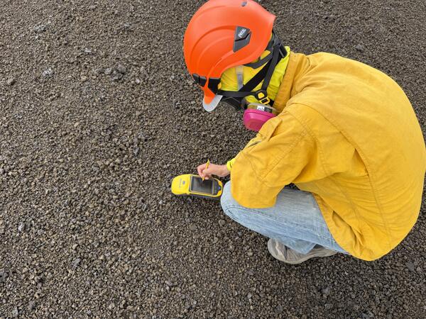
A USGS Hawaiian Volcano Observatory geologist collects high-precision ground positions using a kinematic GPS instrument that measures its vertical and horizontal position. Once processed, these measurements will help scientists determine the thickness of the tephra deposit downwind of the ongoing Halema‘uma‘u eruption at Kīlauea summit. The tephra has primarily been falling in a closed area of Hawai‘i Volcanoes National Park, an area that HVO scientists access with permission from, and in coordination with, the National Park Service. USGS photo taken on May 29, 2025, by L. DeSmither.
Sources/Usage: Public Domain. View Media Details
Media
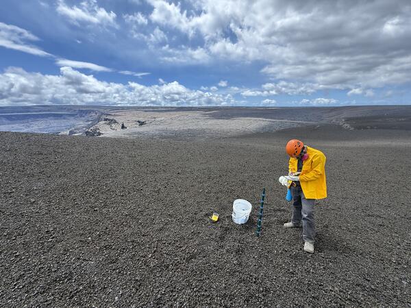
During the pause after episode 23 of the ongoing Kīlauea summit eruption, a USGS Hawaiian Volcano Observatory scientist collects data on the tephra deposits. Buckets are used to collect tephra, and emptied between episodes, to ensure that samples from each episode are isolated to track geochemical changes and determine the amount of tephra that fell at each site. The stake also helps scientists measure the thickness of tephra fall in that area. USGS photo taken by L. DeSmither on May 29, 2025.
Sources/Usage: Public Domain. View Media Details
Media
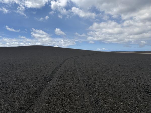
A thick deposit of tephra from the high fountaining of episode 23—along with accumulation from previous episodes—of the ongoing Kīlauea summit eruption, blankets the southwestern rim of Halema‘uma‘u crater. The deposit, within the closed area of Hawai‘i Volcanoes National Park, underscores the hazardous nature of this area. It covers a section of the old Crater Rim Drive which is used by HVO scientists to access important volcano monitoring stations. The hill of tephra on the left side of the image is estimated to be roughly 10-12 m (33-39 ft) thick. USGS photo taken by L. DeSmither on May 29, 2025.
Sources/Usage: Public Domain. View Media Details
Media
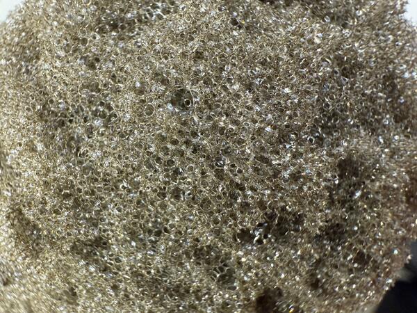
A close-up view looking at one of the more vesicular pieces of tephra from a recent fountaining episode at Kīlauea summit. When the gas-rich lava erupting from the vents quickly cools, it solidifies with this light and frothy texture. The bubble walls are so thin that the color of this tephra is more golden brown. USGS photo taken by L. DeSmither on May 29, 2025.
Sources/Usage: Public Domain. View Media Details
Media
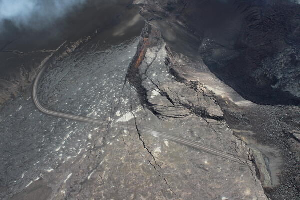
This view of the southwest portion of Halema‘uma‘u (top right of photo) was captured during a USGS Hawaiian Volcano Observatory monitoring helicopter overflight on Wednesday, May 28, 2025. Part of Crater Rim Drive in Hawai‘i Volcanoes National Park, which has been closed to the public since 2007, is visible in the center of the photo. The brown material covering the landscape in the upper left portion of the photo is tephra erupted during the 6 hours of sustained fountaining of episode 23, and is estimated to be over 30 feet (10 meters) thick close to the eruptive vents. USGS photo by R. Adams.
Sources/Usage: Public Domain. View Media Details
Media
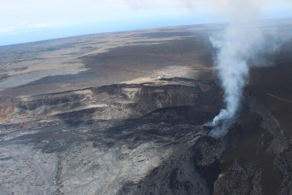
This view of the southwest portion of Halema‘uma‘u, looking to the south, was captured during a USGS Hawaiian Volcano Observatory monitoring helicopter overflight of Kīlauea volcano on Wednesday, May 28, 2025. The north and south vents are degassing on the right side of photo, with the south vent (further from the camera) degassing more strongly. Lava flows from episode 23 (silver appearance) cover most of the bottom left of the photo. USGS photo by R. Adams.
Sources/Usage: Public Domain. View Media Details
Media
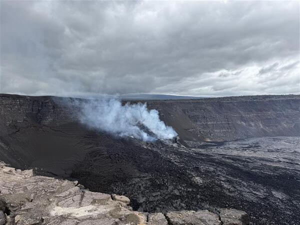
A view from the south rim of Halema‘uma‘u crater looking at the active vents. The ongoing Kīlauea summit eruption that began on December 23, 2024, is currently paused following the high fountaining of episode 23 on Sunday, May 25. The thick tephra deposit on the southwest rim of Halema‘uma‘u is visible as the brown layer on crater rim at the left side of this image. USGS photo taken on May 29, 2025, by L. DeSmither.
Sources/Usage: Public Domain. View Media Details
Media

This compilation shows thermal maps of Kīlauea summit collected on May 14 and 28, 2025. These maps followed episodes 21 and 23 of the ongoing Kīlauea summit eruption, respectively, and both show inactive but warm lava flows produced by the preceding lava fountaining episodes. The May 14 map shows the long, channelized lava flow produced by episode 21 that ran along the north perimeter of the crater floor, while the May 28 map shows the channelized flow from episode 23 that was guided along the south perimeter of the crater floor. Both thermal maps show a warm region in the western crater floor that has commonly hosted a perched lava pond during the lava fountaining phases.
Sources/Usage: Public Domain. View Media Details