
Photo & Video Chronology — November 24, 2025 — Kīlauea summit overflight
By Hawaiian Volcano Observatory
November 25, 2025
On November 24, USGS Hawaiian Volcano Observatory geologists conducted a monitoring overflight of Kīlauea summit, during which they collected visual and thermal imagery and conducted a LiDAR survey. The data collected during the mission will support updated maps reflected conditions since the end of episode 36 on November 9.
Multiple lava overflows from both vents occurred over the weekend, which are precursory to episode 37, and geologists were also able to successfully sample one of these lava flows. The forecast window for episode 37 to start November 25-28.
Media
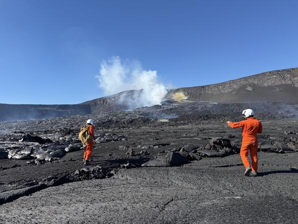
USGS Hawaiian Volcano Observatory scientists landed briefly on Halema‘uma‘u crater floor on November 24, 2025, during a Kīlauea summit monitoring overflight. The north and south vents (center) have produced a series of small Pāhoehoe overflows over the past few days (silver flows on left side of photo), which geologists were able to sample with permission from Hawai‘i Volcanoes National Park. USGS photo taken by M. Warren.
Sources/Usage: Public Domain. View Media Details
Media
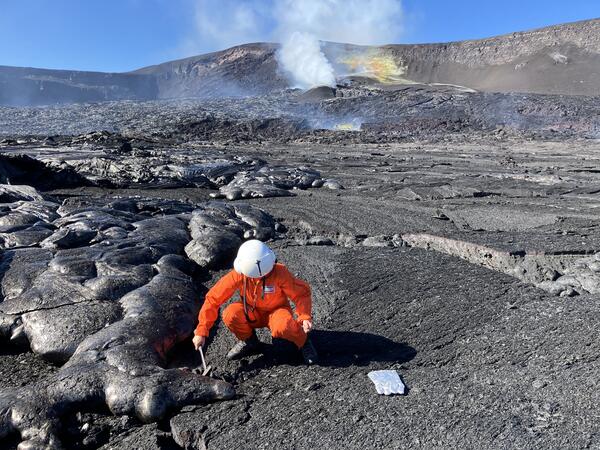
On November 24, a USGS Hawaiian Volcano Observatory helicopter overflight was able to land on the floor of Halema‘uma‘u crater for scientists to collect a sample of cooled lava from a recent overflow of the Kīlauea summit eruptive vents. These overflows—silvery in color when this fresh, as seen on the left of this image—have been erupting intermittently in advance of a likely thirty-seventh lava fountaining episode for the eruption in the coming days. This specific overflow had erupted on November 22 and was no longer emitting much external heat, but the scientists still used water to quench the warm flow interior before transport. Sampling within Halema‘uma‘u, which is done with permission from Hawai‘i Volcanoes National Park, allows for near real-time geochemical analyses, which provide information on the magma plumbing system below, informing our understanding of the hazards associated with the ongoing eruption. USGS photo by M. Zoeller.
Sources/Usage: Public Domain. View Media Details
Media
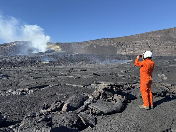
During a helicopter overflight on November 24, USGS Hawaiian Volcano Observatory scientists had the opportunity to document the active vents from the floor of Halema‘uma‘u crater, within Kaluapele (Kīlauea summit caldera). A small patch of smoother Pāhoehoe lava offered an easy place to land and walk around for a few minutes, collecting samples and capturing photos. All Kīlauea summit overflight and sampling missions are done in coordination with Hawai‘i Volcanoes National Park. USGS photo by M. Warren.
Sources/Usage: Public Domain. View Media Details
Media
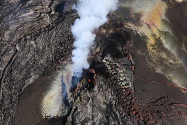
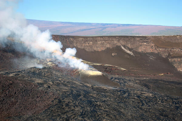
A telephoto aerial view looking down into the north vent (center) of the ongoing Kīlauea summit eruption within Halema‘uma‘u crater. Orange incandescent lava is visible deep in the vent. Lava overflows from both vents over the past few days produced shiny new Pāhoehoe flows (bottom center and left side of photo). Colorful alteration and sulfur deposits have formed on the tephra blankets near the vents. During the pauses between each eruption episode, sulfur dioxide (SO2) gas emission rates remain at around 1,200 to 1,500 tonnes per day. USGS photo taken by L. DeSmither on November 24, 2025.
Sources/Usage: Public Domain. View Media Details
Media
An aerial view looking down into the south vent (center) of the ongoing Kīlauea summit eruption within Halema‘uma‘u crater. A tiny spot of orange incandescent lava was visible deep in the south vent on the morning of November 24 during a USGS Hawaiian Volcano Observatory monitoring helicopter overflight. A thick plume of water vapor and volcanic gas is visible coming from the north vent (lower right). USGS Photo taken by L. DeSmither.
Sources/Usage: Public Domain. View Media Details
Media
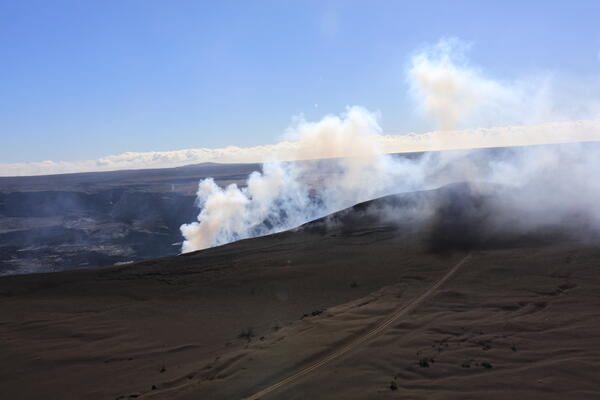
This aerial view looking to the southeast shows the volcanic gas plume being emitted from the vents of the ongoing Halema‘uma‘u eruption at Kīlauea summit. The eruption, which began on December 23, 2024, has blanketed the western rim of the caldera with tephra and is building a large tephra hill on the rim directly downwind of the eruptive vents (center right of photo). Tire tracks in the tephra deposit follow the path of the buried road which USGS scientists continue to use to access important volcano monitoring sites. This road is within a closed area of Hawai‘i Volcanoes National Park that is accessed by the Hawaiian Volcano Observatory with permission from the park service. USGS photo taken by L. DeSmither on November 24, 2025.
Sources/Usage: Public Domain. View Media Details
Media
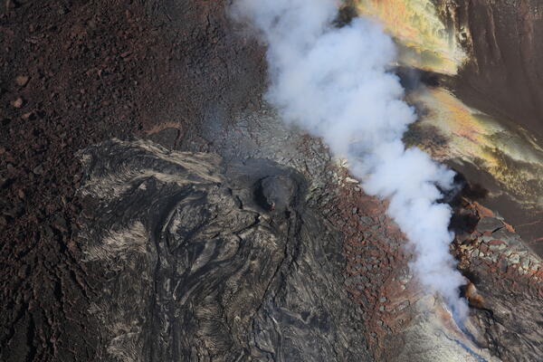
Aerial view within Halema‘uma‘u crater taken during a Kīlauea summit overflight on the morning of November 24, 2025. This view, looking to the northwest, shows the north vent cone (center of image) and south vent cone (center-left) emitting plumes of steam and volcanic gas. Recent activity from both vents, which started again on November 21, produced a series of small Pāhoehoe overflows from the vents (silver flows from center to bottom of photo). The Northeast Rift Zone of Mauna Loa is visible in the background. USGS photo taken by M. Warren.
Sources/Usage: Public Domain. View Media Details