
Volcano Watch — GeoSPACE: The benefits of accommodation and inclusion in geology field experiences
Scientists from the USGS Hawaiian Volcano Observatory (HVO) are collaborating with academic colleagues to make field experiences in geology more accessible for people who have been historically excluded, specifically those with disabilities.
Volcano Watch is a weekly article and activity update written by U.S. Geological Survey Hawaiian Volcano Observatory scientists and affiliates. Today's article is by National Science Foundation Postdoctoral Fellow Lis Gallant.
Visiting rocks in their natural habitat, or “going into the field,” is an important part of geology training because it provides real context for what students learn in the laboratory and classroom. Field courses can be up to 6 weeks long, are located in remote areas, and are often required to complete an undergraduate geology degree program. As traditionally designed, the courses are not accessible to everyone.

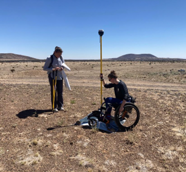
The GeoScientists Promoting Accessible Collaborative Experiences (GeoSPACE) field course takes place simultaneously in the San Francisco Volcanic Field of northern Arizona, USA, and online every summer. Eight different sites within the field area were visited during the first course last summer, and lessons learned will be used to improve subsequent offerings. The course was designed to accommodate students with disabilities, caretaking responsibilities, or other life-situations that make traditional field courses offered by universities difficult to attend and undertake. Currently, less than 5% of students earning geoscience degrees identify as disabled compared to 20% of all undergraduates. Expanding experiential courses to include disabled participants could have significant benefit for the geosciences.
GeoSPACE uses a planetary science mission framework that encourages online and on-the-ground students to work together to explore volcanic landscapes and to develop questions about the geology that they can then answer. Before each day in the field, ‘Mission Control’ (virtual students) provide briefings for the ‘Ground Team’ (in-person students) about their study sites using data from satellites.
Students on the ground use classic geologic field mapping techniques—GPS surveying equipment, unmanned aircraft systems (UAS), ground-based cameras, and real-time communication—to collect data. Incorporating technology into field courses prepares students for a variety of career paths within and beyond volcanology and planetary science.
A mission debrief is conducted at the end of each day, where the Ground Team reports to Mission Control on their findings. The collaborative nature to this approach between those online and those on the ground reflects modern geoscience working environments, such as those used at HVO during eruption responses.
Volcanic fields, areas where many small volcanoes are clustered, provide an excellent natural classroom for accessible fieldwork because they offer great variety over short distances. Volcanic fields are also excellent analogs for eruptive styles on different planets. Students preparing for careers in space science can gain experience with the types of environments they’re likely to encounter conducting planetary research.
The opportunity to learn and thrive in a supportive environment allows students to develop confidence in their ability to succeed in the geosciences. Student feedback indicated that it was empowering to have HVO scientists as part of the faculty team. Being treated as an equal by accomplished scientists gave them confidence in their abilities and made it easier to believe in their own abilities. Students could see themselves as belonging in the geosciences.
Frankie Butler, a student at the University of Aberdeen in Scotland, stated that "...the GeoSPACE field trip was a truly transformative experience. I thought my lifelong dream of being a volcanologist was over after my devastating injury. I missed out on 4 years of field work and had no access to that unique learning environment. I was treated as a scientist; I was part of the discussion and I got to see a real HVO volcanologist in the field! As an undergraduate you don't get the opportunity to see working scientists in the field, seeing their systematic approach to an outcrop and the techniques utilized have helped me become the field geologist I am today."
Faculty members and students have presented about the GeoSPACE program at professional geoscience conferences all over the globe. These presentations have covered topics from the design of the course, findings from the mystery site, mentoring, and student perception of accommodations. You find some of these presentations and learn more about GeoSPACE by visiting our website: https://sites.google.com/ufl.edu/geospace-field-program
Volcano Activity Updates
Kīlauea summit eruption has paused. Its USGS Volcano Alert level is at WATCH. Kīlauea updates are issued daily.
Kīlauea volcano's summit eruption in Halemaʻumaʻu crater within Hawai‘i Volcanoes National Park has paused. Summit tilt has shown several deflation-inflation events over the past week. Summit earthquake activity remains low and eruptive tremor (a signal associated with fluid movement) is present at decreased levels. A sulfur dioxide emission rate of 250 tonnes per day was measured on February 28. For Kīlauea monitoring data, see https://www.usgs.gov/volcanoes/kilauea/past-week-monitoring-data-kilauea.
Mauna Loa is not erupting. Its USGS Volcano Alert Level is at NORMAL. Mauna Loa updates are issued on the first Thursday of the month.
Webcams show no signs of activity on Mauna Loa. Seismicity remains low. Deformation rates show inflation somewhat above background levels, but this is not uncommon following eruptions. Sulfur dioxide (SO2) emission rates are at background levels. For Mauna Loa monitoring data, see: https://www.usgs.gov/volcanoes/mauna-loa/monitoring-data.
There were three earthquakes with 3 or more felt reports in the Hawaiian Islands during the past week: a M2.7 earthquake 23 km (14 mi) SW of Laupāhoehoe at 31 km (19 mi) depth on March 15 at 3:21 p.m. HST, a M3.1 earthquake 5 km (3 mi) SW of Volcano at 0 km (0 mi) depth on March 11 at 11:50 a.m. HST, and a M3.2 earthquake 54 km (33 mi) WNW of Kailua-Kona at 36 km (22 mi) depth on March 10 at 1:46 a.m. HST.
HVO continues to closely monitor Kīlauea and Mauna Loa.
Please visit HVO’s website for past Volcano Watch articles, Kīlauea and Mauna Loa updates, volcano photos, maps, recent earthquake info, and more. Email questions to askHVO@usgs.gov.
Volcano Watch is a weekly article and activity update written by U.S. Geological Survey Hawaiian Volcano Observatory scientists and affiliates.