



Volcano Watch — Where did the September fissure vent lava at Kīlauea's summit come from?
On September 14–16, 2026, a set of six new eruptive fissure vents opened at Kīlauea summit along the western wall of Halemaʻumaʻu. These vents opened after a period of repressurization of the summit magma storage system that had taken place since the end of episode 54 of the ongoing summit eruption in August.
Volcano Watch is a weekly article and activity update written by U.S. Geological Survey Hawaiian Volcano Observatory scientists and affiliates. Today's article is written by HVO geologist Heather Winslow and USGS data scientist Marco Bagnardi.
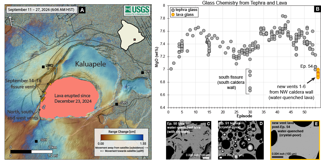
Pressure increases in the summit magma reservoir are inferred primarily from deformation data collected by instruments around the summit area. The Uēkahuna tiltmeter (UWD), for example, measured approximately 13 microradians of ground tilt downwards towards the center of the crater during episode 54 on August 25, 2026. This tilt indicated a decrease in pressure in the magma reservoir during fountaining. The pressure drop had fully recovered by September 7, when the tilt recorded at UWD returned to pre-fountaining level. At that point, the summit vents began to overflow, indicating that pressure in the summit reservoir had been rebuilt.
However, fountaining did not follow the overflows as it had during previous episodes. Instead, the summit storage system continued to further pressurize, although intermittently. Along with tilt data, Global Navigation Satellite System (GNSS, often referred to as GPS), also indicated increasing pressure through uplift and extension across the summit area of Kīlauea. This further pressure increase led to the opening of the new fissures on September 14–16.
The 6 new vents extend from 0.1–0.6 miles (250 m to 1,000 m) north of the main vent complex in Halemaʻumaʻu where lava fountaining occurs and lie about 150 feet (45 meters) below the base level of the northern vent. The new vents opened without significant seismicity or surface deformation. For example, an Interferometric Synthetic Aperture Radar (InSAR) satellite image spanning the opening of the vents did not record any significant surface displacements in the proximity of the new vents or elsewhere. The absence of seismicity and deformation suggests that magma could have moved through preexisting cracks or pathways, or that the magma opened a new path to the surface without significantly fracturing and displacing the adjacent solid rock.
USGS Hawaiian Volcano Observatory (HVO) geologists sampled the lava from the new vents while they were still erupting to determine the magma’s origin. They were able to collect water-quenched samples, which is done while lava is still molten. HVO geologists scoop the molten lava into a bucket of water to rapidly cool the sample. This method is preferred because it preserves the pre-eruptive chemistry and crystal sizes (termed “texture”), which can otherwise be altered when lava slowly cools and solidifies at the surface.
The texture and chemistry of the lava that erupted from the six new vents in September show that the new fissure lavas match what has usually erupted from the shallow magma chamber beneath Halemaʻumaʻu. The water-quenched sample was mostly glassy (meaning it had very few crystals) and its chemistry was very close to material erupted during episode 54, with about 6.9 weight percent magnesium oxide (MgO).
The chemistry and texture of the lava tell us several important things:
1) The fissure vents were not fed by fresh, new, deeper magma. If they were, the lava would contain more magnesium (MgO) and be much hotter.
2) The lava’s low crystal content shows it also wasn’t residual material from an older buried lava lake eruption being squeezed out by increasing pressure.
3) Because the new lava has similar MgO levels and is crystal-poor, it most likely came from the same shallow magma chamber beneath Halemaʻumaʻu that feeds typical fountaining episodes.
The combination of deformation and geochemical datasets show that the new fissure vents that formed and erupted in September were the same magma source we have seen in previous fountaining episodes. The vents likely formed because the magma system was highly pressurized and simply forced its way along the easiest path to the surface.
This quiet opening of new vents in September differed from the intrusion northeast of the eruptive vents in Halemaʻumaʻu from September 30-October 1. Though lava didn’t make it to the surface then, over 100 earthquakes and significant ground surface deformation occurred as new cracks formed on the caldera floor. With continued pressurization at Kīlauea, changes remain possible both below and above the surface.
Volcano Activity Updates
Kīlauea has been erupting episodically within the summit caldera since December 23, 2024. Its USGS Volcano Alert level is WATCH.
North and south vents in Halemaʻumaʻu have intermittently erupted spatter and lava flows over the past week, with strong glow and flames visible overnight. Sulfur dioxide emissions are in the range of 1,000-5,000 tonnes per day. Kīlauea's summit region remains at a high level of pressurization. Current conditions remain favorable for another fountaining episode or change in eruptive activity. No unusual activity has been noted along Kīlauea’s East Rift Zone or Southwest Rift Zone.
Mauna Loa is not erupting. Its USGS Volcano Alert Level is at NORMAL.
One earthquake was reported felt in the Hawaiian Islands during the past week: a M3.1 earthquake 12 km (7 mi) SSE of Fern Forest at 6 km (3 mi) depth on Oct. 12 at 3:09 p.m. HST.
HVO continues to closely monitor Kīlauea and Mauna Loa.
Please visit HVO’s website for past Volcano Watch articles, Kīlauea and Mauna Loa updates, volcano photos, maps, recent earthquake information, and more. Email questions to askHVO@usgs.gov.