An official website of the United States government
Here's how you know
Official websites use .gov
A .gov website belongs to an official government organization in the United States.
Secure .gov websites use HTTPS
A lock () or https:// means you’ve safely connected to the .gov website. Share sensitive information only on official, secure websites.
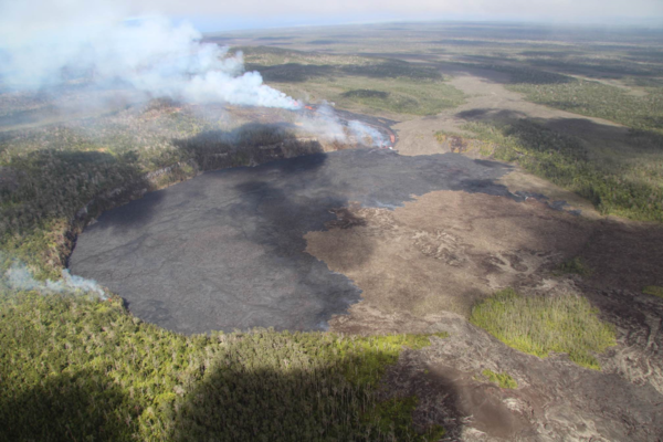
This photograph of Kīlauea's middle East Rift Zone eruption was captured during a Hawaiian Volcano Observatory helicopter overflight during the morning of September 17, 2024. Geologists observed fountaining eruptive fissures and active lava flows on the floor of Nāpau Crater, just downrift (northeast) of the September 15 eruptive fissure. This south-facing view shows the current activity from the north side of Nāpau Crater. USGS photo by A. Ellis.
Magma intruded beneath the ground near Makaopuhi Crater—a well-known magma storage region on Kīlauea’s middle East Rift Zone on September 14. HVO published a Status Report alerting the public and partners to the activity, which was accompanied by hundreds of earthquakes and ground deformation.
PHASE 1: a brief eruption occurred west of Nāpau Crater on the middle East Rift Zone between 9 and 10 p.m. HST on September 15. 2024. Infrasound sensors in HVO’s monitoring network recorded strong signals indicative of gas or steam venting. At the same time, HVO’s seismometers recorded weak but sustained low frequency tremor. Although an eruption could not be confirmed visually Sunday night by webcams or satellite thermal data due to heavy rainfall, the geophysical data indicated that an eruption could be taking place. That night, some residents in nearby communities also reported strong sulfur or burning smells. The alert level and aviation color code for Kīlauea is raised to ORANGE/WATCH. During an overflight the next morning, geologists observed that a 480-meter (1600-foot) long fissure had covered 16,500 square meters (4 acres) with about 20,000 cubic meters (about 5 million gallons) of lava. Lava was no longer flowing on the surface as of Monday, but magma was still moving underground as detected by seismometers, tiltmeters and GPS.
PHASE 2: NOAA GOES satellite thermal imagery and HVO webcam imagery detect that the eruption has resumed around 6 p.m. HST on September 16. Interestingly, no changes were detected in other monitoring datasets. Fissures from this phase of the eruption produced lava fountains and flows that gradually decreased through the night. But activity would soon resume.
USGS Hawaiian Volcano Observatory geologists conducted a reconnaissance overflight of the eruption near Nāpau Crater on the middle East Rift Zone of Kīlauea on September 19, 2024. They observed lava cascading over the rim of the crater from a channel more than 50 meters (about 164 feet) wide. Lava was contained within Nāpau Crater and covered about two thirds of the crater floor. USGS photo by M. Zoeller.
PHASE 3: Between 4 and 5 a.m. HST September 17, infrasound signals, a GOES satellite thermal anomaly, and webcam imagery indicated that the eruption had resumed. After sunrise, HVO scientists on a helicopter overflight observed new vents had opened in Nāpau Crater, with several lava fountains approximately 10 meters (yards) high generating lava flows on the floor of Nāpau Crater. This eruptive phase was more vigorous, l longer lived and continued at gradually decreasing levels through Wednesday afternoon. In total, the fissure system has stretched over 1.6 kilometers (1.0 miles) of the East Rift Zone, with lava flows now covering 18 hectares (44 acres).
PHASE 4: At 3:15 p.m. HST, on September 18, new eruptive fissures opened west of Nāpau Crater. A monitoring camera deployed by HVO field crews with permission from Hawaiʻi Volcanoes National Park recorded “lava falls” cascading down the northwest walls of Nāpau Crater. Vigorous activity continued and by the morning of September 19, about 2/3 of Nāpau Crater floor had been covered with new lava. As of 10 a.m. HST on September 20 morning, phase 4 eruptive activity had ended.
September 19, 2024 —Kīlauea middle East Rift Zone eruption overflight
The 150-m-long (nearly 500 feet) fissure erupting west of Nāpau Crater within Hawaʻi Volcanoes National Park began erupting yesterday, September 18, around 3:15 p.m. It's part of an eruptive sequence that began in this area the night of September 15, 2024.
The 150-m-long (nearly 500 feet) fissure erupting west of Nāpau Crater within Hawaʻi Volcanoes National Park began erupting yesterday, September 18, around 3:15 p.m. It's part of an eruptive sequence that began in this area the night of September 15, 2024.
September 19, 2024 —Kīlauea middle East Rift Zone eruption overflight
USGS Hawaiian Volcano Observatory geologists conducted a reconnaissance overflight of the eruption near Nāpau Crater on the middle East Rift Zone of Kīlauea. New lava from fissure eruptions over the past several days now covers about two thirds of the crater floor. USGS photo by M. Zoeller.
USGS Hawaiian Volcano Observatory geologists conducted a reconnaissance overflight of the eruption near Nāpau Crater on the middle East Rift Zone of Kīlauea. New lava from fissure eruptions over the past several days now covers about two thirds of the crater floor. USGS photo by M. Zoeller.
September 19, 2024—New lava flows on the middle East Rift Zone of Kīlauea
On September 19, 2024, USGS-Hawaiian Volcano Observatory geologists landed near the Kīlauea middle East Rift Zone eruption site, where they viewed lava flowing through a channel more than 50 meters (about 164 feet) wide. USGS photo by M. Zoeller.
On September 19, 2024, USGS-Hawaiian Volcano Observatory geologists landed near the Kīlauea middle East Rift Zone eruption site, where they viewed lava flowing through a channel more than 50 meters (about 164 feet) wide. USGS photo by M. Zoeller.
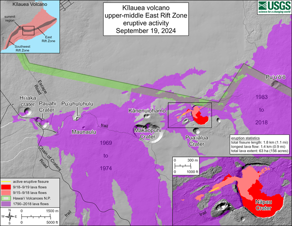
September 19, 2024 —Kīlauea middle East Rift Zone eruption reference map
This reference map depicts fissures and lava flows from the Kīlauea middle East Rift Zone eruption on Thursday, September 19, 2024. Map data are current as of the Hawaiian Volcano Observatory helicopter overflight that occurred between 9:00 and 10:00 a.m.
This reference map depicts fissures and lava flows from the Kīlauea middle East Rift Zone eruption on Thursday, September 19, 2024. Map data are current as of the Hawaiian Volcano Observatory helicopter overflight that occurred between 9:00 and 10:00 a.m.
September 19, 2024 — Thermal map of eruption on Kīlauea East Rift Zone
A helicopter overflight on September 19, 2024, allowed for aerial visual and thermal imagery to be collected at the middle East Rift Zone eruption site on Kīlauea. The eruptive activity continues with a fissure vent active west of Nāpau Crater generating lava flows northeast into the crater.
A helicopter overflight on September 19, 2024, allowed for aerial visual and thermal imagery to be collected at the middle East Rift Zone eruption site on Kīlauea. The eruptive activity continues with a fissure vent active west of Nāpau Crater generating lava flows northeast into the crater.
September 19, 2024 —Kīlauea middle East Rift Zone eruption overflight
USGS Hawaiian Volcano Observatory geologists conducted a reconnaissance overflight of the eruption near Nāpau Crater on the middle East Rift Zone of Kīlauea. They observed lava cascading over the rim of the crater from a channel more than 50 meters (about 164 feet) wide. Lava is contained within Nāpau Crater and now covers about two thirds of the crater floor.
USGS Hawaiian Volcano Observatory geologists conducted a reconnaissance overflight of the eruption near Nāpau Crater on the middle East Rift Zone of Kīlauea. They observed lava cascading over the rim of the crater from a channel more than 50 meters (about 164 feet) wide. Lava is contained within Nāpau Crater and now covers about two thirds of the crater floor.
September 19, 2024 —Kīlauea middle East Rift Zone eruption
USGS Hawaiian Volcano Observatory geologists conducted a reconnaissance overflight of the eruption near Nāpau Crater on the middle East Rift Zone of Kīlauea. They observed a 150-m-long (nearly 500 feet) fissure west of the crater erupting lava in a curtain of lava 10-20 meters (33-66 feet) high. USGS photo by M. Zoeller.
USGS Hawaiian Volcano Observatory geologists conducted a reconnaissance overflight of the eruption near Nāpau Crater on the middle East Rift Zone of Kīlauea. They observed a 150-m-long (nearly 500 feet) fissure west of the crater erupting lava in a curtain of lava 10-20 meters (33-66 feet) high. USGS photo by M. Zoeller.
September 19, 2024 —Kīlauea middle East Rift Zone eruption overflight
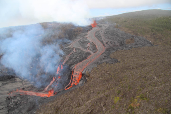
USGS Hawaiian Volcano Observatory geologists conducted a reconnaissance overflight of the eruption near Nāpau Crater on the middle East Rift Zone of Kīlauea. They observed a 150-m-long (nearly 500 feet) fissure west of the crater erupting lava that is flowing in the crater via a channel more than 50 meters (about 164 feet) wide.
USGS Hawaiian Volcano Observatory geologists conducted a reconnaissance overflight of the eruption near Nāpau Crater on the middle East Rift Zone of Kīlauea. They observed a 150-m-long (nearly 500 feet) fissure west of the crater erupting lava that is flowing in the crater via a channel more than 50 meters (about 164 feet) wide.
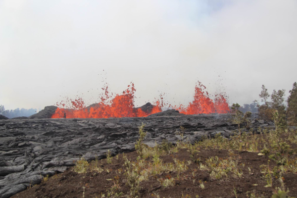
September 18, 2024 —lava spattering during the Kīlauea middle East Rift Zone eruption
From the ground in Nāpau Crater, spattering lava was visible above the newly formed lava flows. This eruption is taking place on the remote middle East Rift Zone of Kīlauea, within Hawaiʻi Volcanoes National Park. USGS photo by H. Winslow.
From the ground in Nāpau Crater, spattering lava was visible above the newly formed lava flows. This eruption is taking place on the remote middle East Rift Zone of Kīlauea, within Hawaiʻi Volcanoes National Park. USGS photo by H. Winslow.
September 18, 2024 —Kīlauea middle East Rift Zone eruption
Weak low fountaining in a tiny lava pond within Nāpau Crater was visible during a morning Hawaiian Volcano Observatory eruption monitoring overflight on September 18, 2024. The eruptive activity has greatly decreased compared to yesterday. USGS photo by H. Winslow.
Weak low fountaining in a tiny lava pond within Nāpau Crater was visible during a morning Hawaiian Volcano Observatory eruption monitoring overflight on September 18, 2024. The eruptive activity has greatly decreased compared to yesterday. USGS photo by H. Winslow.
September 18, 2024 —Kīlauea middle East Rift Zone eruption
During a USGS Hawaiian Volcano Observatory monitoring overflight the morning of September 18, geologists observed only very weak activity at Kīlauea's middle East Rift Zone eruption site in Nāpau Crater.
During a USGS Hawaiian Volcano Observatory monitoring overflight the morning of September 18, geologists observed only very weak activity at Kīlauea's middle East Rift Zone eruption site in Nāpau Crater.
September 18, 2024 —lava oozes during the active Kīlauea eruption
Although most of the lava flow field within Nāpau Crater was inactive this morning, lava was actively oozing out of a marginal area. USGS photo by H. Winslow.
Although most of the lava flow field within Nāpau Crater was inactive this morning, lava was actively oozing out of a marginal area. USGS photo by H. Winslow.
September 18, 2024 — Thermal map of eruption on Kīlauea East Rift Zone
A helicopter overflight on September 18, 2024, allowed for aerial visual and thermal imagery to be collected at the middle East Rift Zone eruption site on Kīlauea. The eruptive activity continues with a single low fountain active within Nāpau Crater and much of the flow field on the crater floor stagnant.
A helicopter overflight on September 18, 2024, allowed for aerial visual and thermal imagery to be collected at the middle East Rift Zone eruption site on Kīlauea. The eruptive activity continues with a single low fountain active within Nāpau Crater and much of the flow field on the crater floor stagnant.
September 18, 2024 — Steam and volcanic gas on Kīlauea East Rift Zone
Steam and volcanic gas continue to be emitted from the first fissures that erupted the night of September 15 on the middle East Rift Zone of Kīlauea, west of Nāpau Crater. This photo, taken during morning monitoring overflight, looks southeast. USGS photo by H. Winslow.
Steam and volcanic gas continue to be emitted from the first fissures that erupted the night of September 15 on the middle East Rift Zone of Kīlauea, west of Nāpau Crater. This photo, taken during morning monitoring overflight, looks southeast. USGS photo by H. Winslow.
September 18, 2024 —Kīlauea middle East Rift Zone eruption reference map
This reference map depicts fissures and lava flows from the Kīlauea middle East Rift Zone eruption as of the end of the day on Wednesday, September 18, 2024. Areas in bright red represent new lava flows since the area was last mapped during the morning of September 17, when activity was focused within Nāpau Crater.
This reference map depicts fissures and lava flows from the Kīlauea middle East Rift Zone eruption as of the end of the day on Wednesday, September 18, 2024. Areas in bright red represent new lava flows since the area was last mapped during the morning of September 17, when activity was focused within Nāpau Crater.
September 18, 2024—Kīlauea middle East Rift Zone eruption glow visible from Chain of Craters Road
During the evening of September 18, the glow from the middle East Rift Zone eruption of Kīlauea was visible from the Keauhou Trail pull-off within Hawaiʻi Volcanoes National Park. USGS photo by K. Mulliken.
During the evening of September 18, the glow from the middle East Rift Zone eruption of Kīlauea was visible from the Keauhou Trail pull-off within Hawaiʻi Volcanoes National Park. USGS photo by K. Mulliken.
September 17, 2024 —Kīlauea middle East Rift Zone eruption
This photograph of Kīlauea's ongoing middle East Rift Zone eruption was captured during a Hawaiian Volcano Observatory helicopter overflight during the morning of September 17, 2024. This photo was taken at 7:30 am H.S.T.
This photograph of Kīlauea's ongoing middle East Rift Zone eruption was captured during a Hawaiian Volcano Observatory helicopter overflight during the morning of September 17, 2024. This photo was taken at 7:30 am H.S.T.
September 17, 2024 —Kīlauea middle East Rift Zone eruption sampling
USGS Hawaiian Volcano Observatory geologists collected a sample of the middle East Rift Zone Kīlauea eruption in Nāpau Crater, within a closed area Hawaiʻi Volcanoes National Park. Geologists put molten lava into a metal bucket and rapidly quench it with water.
USGS Hawaiian Volcano Observatory geologists collected a sample of the middle East Rift Zone Kīlauea eruption in Nāpau Crater, within a closed area Hawaiʻi Volcanoes National Park. Geologists put molten lava into a metal bucket and rapidly quench it with water.
Fissures bisecting Nāpau Crater during the eruption of Kīlauea's middle East Rift Zone, September 17, 2024
This photograph of Kīlauea's ongoing middle East Rift Zone eruption was captured during a Hawaiian Volcano Observatory helicopter overflight during the morning of September 17, 2024. Geologists observed fountaining eruptive fissures and active lava flows bisecting the floor of Nāpau Crater, just downrift (northeast) of the September 15 eruptive fissure.
This photograph of Kīlauea's ongoing middle East Rift Zone eruption was captured during a Hawaiian Volcano Observatory helicopter overflight during the morning of September 17, 2024. Geologists observed fountaining eruptive fissures and active lava flows bisecting the floor of Nāpau Crater, just downrift (northeast) of the September 15 eruptive fissure.
September 17, 2024 —Kīlauea middle East Rift Zone eruption
This photograph of Kīlauea's ongoing middle East Rift Zone eruption was captured during a Hawaiian Volcano Observatory helicopter overflight during the morning of September 17, 2024. Geologists observed fountaining eruptive fissures and active lava flows on the floor of Nāpau Crater, just downrift (northeast) of the September 15 eruptive fissure.
This photograph of Kīlauea's ongoing middle East Rift Zone eruption was captured during a Hawaiian Volcano Observatory helicopter overflight during the morning of September 17, 2024. Geologists observed fountaining eruptive fissures and active lava flows on the floor of Nāpau Crater, just downrift (northeast) of the September 15 eruptive fissure.
September 17, 2024 —Kīlauea middle East Rift Zone eruption overflight
Kīlauea volcano is erupting in Hawai’i Volcanoes National Park from a new fissure vent that opened within Nāpau Crater this morning, September 17, between 4:00 and 5:00 AM HST. The eruption is occurring within a closed and remote area of Hawaiʻi Volcanoes National Park.
Kīlauea volcano is erupting in Hawai’i Volcanoes National Park from a new fissure vent that opened within Nāpau Crater this morning, September 17, between 4:00 and 5:00 AM HST. The eruption is occurring within a closed and remote area of Hawaiʻi Volcanoes National Park.
This photograph of Kīlauea's middle East Rift Zone eruption was captured during a Hawaiian Volcano Observatory helicopter overflight during the morning of September 17, 2024. Geologists observed fountaining eruptive fissures and active lava flows on the floor of Nāpau Crater, just downrift (northeast) of the September 15 eruptive fissure. This south-facing view shows the current activity from the north side of Nāpau Crater. USGS photo by A. Ellis.
Magma intruded beneath the ground near Makaopuhi Crater—a well-known magma storage region on Kīlauea’s middle East Rift Zone on September 14. HVO published a Status Report alerting the public and partners to the activity, which was accompanied by hundreds of earthquakes and ground deformation.
PHASE 1: a brief eruption occurred west of Nāpau Crater on the middle East Rift Zone between 9 and 10 p.m. HST on September 15. 2024. Infrasound sensors in HVO’s monitoring network recorded strong signals indicative of gas or steam venting. At the same time, HVO’s seismometers recorded weak but sustained low frequency tremor. Although an eruption could not be confirmed visually Sunday night by webcams or satellite thermal data due to heavy rainfall, the geophysical data indicated that an eruption could be taking place. That night, some residents in nearby communities also reported strong sulfur or burning smells. The alert level and aviation color code for Kīlauea is raised to ORANGE/WATCH. During an overflight the next morning, geologists observed that a 480-meter (1600-foot) long fissure had covered 16,500 square meters (4 acres) with about 20,000 cubic meters (about 5 million gallons) of lava. Lava was no longer flowing on the surface as of Monday, but magma was still moving underground as detected by seismometers, tiltmeters and GPS.
PHASE 2: NOAA GOES satellite thermal imagery and HVO webcam imagery detect that the eruption has resumed around 6 p.m. HST on September 16. Interestingly, no changes were detected in other monitoring datasets. Fissures from this phase of the eruption produced lava fountains and flows that gradually decreased through the night. But activity would soon resume.
USGS Hawaiian Volcano Observatory geologists conducted a reconnaissance overflight of the eruption near Nāpau Crater on the middle East Rift Zone of Kīlauea on September 19, 2024. They observed lava cascading over the rim of the crater from a channel more than 50 meters (about 164 feet) wide. Lava was contained within Nāpau Crater and covered about two thirds of the crater floor. USGS photo by M. Zoeller.
PHASE 3: Between 4 and 5 a.m. HST September 17, infrasound signals, a GOES satellite thermal anomaly, and webcam imagery indicated that the eruption had resumed. After sunrise, HVO scientists on a helicopter overflight observed new vents had opened in Nāpau Crater, with several lava fountains approximately 10 meters (yards) high generating lava flows on the floor of Nāpau Crater. This eruptive phase was more vigorous, l longer lived and continued at gradually decreasing levels through Wednesday afternoon. In total, the fissure system has stretched over 1.6 kilometers (1.0 miles) of the East Rift Zone, with lava flows now covering 18 hectares (44 acres).
PHASE 4: At 3:15 p.m. HST, on September 18, new eruptive fissures opened west of Nāpau Crater. A monitoring camera deployed by HVO field crews with permission from Hawaiʻi Volcanoes National Park recorded “lava falls” cascading down the northwest walls of Nāpau Crater. Vigorous activity continued and by the morning of September 19, about 2/3 of Nāpau Crater floor had been covered with new lava. As of 10 a.m. HST on September 20 morning, phase 4 eruptive activity had ended.
September 19, 2024 —Kīlauea middle East Rift Zone eruption overflight
The 150-m-long (nearly 500 feet) fissure erupting west of Nāpau Crater within Hawaʻi Volcanoes National Park began erupting yesterday, September 18, around 3:15 p.m. It's part of an eruptive sequence that began in this area the night of September 15, 2024.
The 150-m-long (nearly 500 feet) fissure erupting west of Nāpau Crater within Hawaʻi Volcanoes National Park began erupting yesterday, September 18, around 3:15 p.m. It's part of an eruptive sequence that began in this area the night of September 15, 2024.
September 19, 2024 —Kīlauea middle East Rift Zone eruption overflight
USGS Hawaiian Volcano Observatory geologists conducted a reconnaissance overflight of the eruption near Nāpau Crater on the middle East Rift Zone of Kīlauea. New lava from fissure eruptions over the past several days now covers about two thirds of the crater floor. USGS photo by M. Zoeller.
USGS Hawaiian Volcano Observatory geologists conducted a reconnaissance overflight of the eruption near Nāpau Crater on the middle East Rift Zone of Kīlauea. New lava from fissure eruptions over the past several days now covers about two thirds of the crater floor. USGS photo by M. Zoeller.
September 19, 2024—New lava flows on the middle East Rift Zone of Kīlauea
On September 19, 2024, USGS-Hawaiian Volcano Observatory geologists landed near the Kīlauea middle East Rift Zone eruption site, where they viewed lava flowing through a channel more than 50 meters (about 164 feet) wide. USGS photo by M. Zoeller.
On September 19, 2024, USGS-Hawaiian Volcano Observatory geologists landed near the Kīlauea middle East Rift Zone eruption site, where they viewed lava flowing through a channel more than 50 meters (about 164 feet) wide. USGS photo by M. Zoeller.
September 19, 2024 —Kīlauea middle East Rift Zone eruption reference map
This reference map depicts fissures and lava flows from the Kīlauea middle East Rift Zone eruption on Thursday, September 19, 2024. Map data are current as of the Hawaiian Volcano Observatory helicopter overflight that occurred between 9:00 and 10:00 a.m.
This reference map depicts fissures and lava flows from the Kīlauea middle East Rift Zone eruption on Thursday, September 19, 2024. Map data are current as of the Hawaiian Volcano Observatory helicopter overflight that occurred between 9:00 and 10:00 a.m.
September 19, 2024 — Thermal map of eruption on Kīlauea East Rift Zone
A helicopter overflight on September 19, 2024, allowed for aerial visual and thermal imagery to be collected at the middle East Rift Zone eruption site on Kīlauea. The eruptive activity continues with a fissure vent active west of Nāpau Crater generating lava flows northeast into the crater.
A helicopter overflight on September 19, 2024, allowed for aerial visual and thermal imagery to be collected at the middle East Rift Zone eruption site on Kīlauea. The eruptive activity continues with a fissure vent active west of Nāpau Crater generating lava flows northeast into the crater.
September 19, 2024 —Kīlauea middle East Rift Zone eruption overflight
USGS Hawaiian Volcano Observatory geologists conducted a reconnaissance overflight of the eruption near Nāpau Crater on the middle East Rift Zone of Kīlauea. They observed lava cascading over the rim of the crater from a channel more than 50 meters (about 164 feet) wide. Lava is contained within Nāpau Crater and now covers about two thirds of the crater floor.
USGS Hawaiian Volcano Observatory geologists conducted a reconnaissance overflight of the eruption near Nāpau Crater on the middle East Rift Zone of Kīlauea. They observed lava cascading over the rim of the crater from a channel more than 50 meters (about 164 feet) wide. Lava is contained within Nāpau Crater and now covers about two thirds of the crater floor.
September 19, 2024 —Kīlauea middle East Rift Zone eruption
USGS Hawaiian Volcano Observatory geologists conducted a reconnaissance overflight of the eruption near Nāpau Crater on the middle East Rift Zone of Kīlauea. They observed a 150-m-long (nearly 500 feet) fissure west of the crater erupting lava in a curtain of lava 10-20 meters (33-66 feet) high. USGS photo by M. Zoeller.
USGS Hawaiian Volcano Observatory geologists conducted a reconnaissance overflight of the eruption near Nāpau Crater on the middle East Rift Zone of Kīlauea. They observed a 150-m-long (nearly 500 feet) fissure west of the crater erupting lava in a curtain of lava 10-20 meters (33-66 feet) high. USGS photo by M. Zoeller.
September 19, 2024 —Kīlauea middle East Rift Zone eruption overflight
USGS Hawaiian Volcano Observatory geologists conducted a reconnaissance overflight of the eruption near Nāpau Crater on the middle East Rift Zone of Kīlauea. They observed a 150-m-long (nearly 500 feet) fissure west of the crater erupting lava that is flowing in the crater via a channel more than 50 meters (about 164 feet) wide.
USGS Hawaiian Volcano Observatory geologists conducted a reconnaissance overflight of the eruption near Nāpau Crater on the middle East Rift Zone of Kīlauea. They observed a 150-m-long (nearly 500 feet) fissure west of the crater erupting lava that is flowing in the crater via a channel more than 50 meters (about 164 feet) wide.
September 18, 2024 —lava spattering during the Kīlauea middle East Rift Zone eruption
From the ground in Nāpau Crater, spattering lava was visible above the newly formed lava flows. This eruption is taking place on the remote middle East Rift Zone of Kīlauea, within Hawaiʻi Volcanoes National Park. USGS photo by H. Winslow.
From the ground in Nāpau Crater, spattering lava was visible above the newly formed lava flows. This eruption is taking place on the remote middle East Rift Zone of Kīlauea, within Hawaiʻi Volcanoes National Park. USGS photo by H. Winslow.
September 18, 2024 —Kīlauea middle East Rift Zone eruption
Weak low fountaining in a tiny lava pond within Nāpau Crater was visible during a morning Hawaiian Volcano Observatory eruption monitoring overflight on September 18, 2024. The eruptive activity has greatly decreased compared to yesterday. USGS photo by H. Winslow.
Weak low fountaining in a tiny lava pond within Nāpau Crater was visible during a morning Hawaiian Volcano Observatory eruption monitoring overflight on September 18, 2024. The eruptive activity has greatly decreased compared to yesterday. USGS photo by H. Winslow.
September 18, 2024 —Kīlauea middle East Rift Zone eruption
During a USGS Hawaiian Volcano Observatory monitoring overflight the morning of September 18, geologists observed only very weak activity at Kīlauea's middle East Rift Zone eruption site in Nāpau Crater.
During a USGS Hawaiian Volcano Observatory monitoring overflight the morning of September 18, geologists observed only very weak activity at Kīlauea's middle East Rift Zone eruption site in Nāpau Crater.
September 18, 2024 —lava oozes during the active Kīlauea eruption
Although most of the lava flow field within Nāpau Crater was inactive this morning, lava was actively oozing out of a marginal area. USGS photo by H. Winslow.
Although most of the lava flow field within Nāpau Crater was inactive this morning, lava was actively oozing out of a marginal area. USGS photo by H. Winslow.
September 18, 2024 — Thermal map of eruption on Kīlauea East Rift Zone
A helicopter overflight on September 18, 2024, allowed for aerial visual and thermal imagery to be collected at the middle East Rift Zone eruption site on Kīlauea. The eruptive activity continues with a single low fountain active within Nāpau Crater and much of the flow field on the crater floor stagnant.
A helicopter overflight on September 18, 2024, allowed for aerial visual and thermal imagery to be collected at the middle East Rift Zone eruption site on Kīlauea. The eruptive activity continues with a single low fountain active within Nāpau Crater and much of the flow field on the crater floor stagnant.
September 18, 2024 — Steam and volcanic gas on Kīlauea East Rift Zone
Steam and volcanic gas continue to be emitted from the first fissures that erupted the night of September 15 on the middle East Rift Zone of Kīlauea, west of Nāpau Crater. This photo, taken during morning monitoring overflight, looks southeast. USGS photo by H. Winslow.
Steam and volcanic gas continue to be emitted from the first fissures that erupted the night of September 15 on the middle East Rift Zone of Kīlauea, west of Nāpau Crater. This photo, taken during morning monitoring overflight, looks southeast. USGS photo by H. Winslow.
September 18, 2024 —Kīlauea middle East Rift Zone eruption reference map
This reference map depicts fissures and lava flows from the Kīlauea middle East Rift Zone eruption as of the end of the day on Wednesday, September 18, 2024. Areas in bright red represent new lava flows since the area was last mapped during the morning of September 17, when activity was focused within Nāpau Crater.
This reference map depicts fissures and lava flows from the Kīlauea middle East Rift Zone eruption as of the end of the day on Wednesday, September 18, 2024. Areas in bright red represent new lava flows since the area was last mapped during the morning of September 17, when activity was focused within Nāpau Crater.
September 18, 2024—Kīlauea middle East Rift Zone eruption glow visible from Chain of Craters Road
During the evening of September 18, the glow from the middle East Rift Zone eruption of Kīlauea was visible from the Keauhou Trail pull-off within Hawaiʻi Volcanoes National Park. USGS photo by K. Mulliken.
During the evening of September 18, the glow from the middle East Rift Zone eruption of Kīlauea was visible from the Keauhou Trail pull-off within Hawaiʻi Volcanoes National Park. USGS photo by K. Mulliken.
September 17, 2024 —Kīlauea middle East Rift Zone eruption
This photograph of Kīlauea's ongoing middle East Rift Zone eruption was captured during a Hawaiian Volcano Observatory helicopter overflight during the morning of September 17, 2024. This photo was taken at 7:30 am H.S.T.
This photograph of Kīlauea's ongoing middle East Rift Zone eruption was captured during a Hawaiian Volcano Observatory helicopter overflight during the morning of September 17, 2024. This photo was taken at 7:30 am H.S.T.
September 17, 2024 —Kīlauea middle East Rift Zone eruption sampling
USGS Hawaiian Volcano Observatory geologists collected a sample of the middle East Rift Zone Kīlauea eruption in Nāpau Crater, within a closed area Hawaiʻi Volcanoes National Park. Geologists put molten lava into a metal bucket and rapidly quench it with water.
USGS Hawaiian Volcano Observatory geologists collected a sample of the middle East Rift Zone Kīlauea eruption in Nāpau Crater, within a closed area Hawaiʻi Volcanoes National Park. Geologists put molten lava into a metal bucket and rapidly quench it with water.
Fissures bisecting Nāpau Crater during the eruption of Kīlauea's middle East Rift Zone, September 17, 2024
This photograph of Kīlauea's ongoing middle East Rift Zone eruption was captured during a Hawaiian Volcano Observatory helicopter overflight during the morning of September 17, 2024. Geologists observed fountaining eruptive fissures and active lava flows bisecting the floor of Nāpau Crater, just downrift (northeast) of the September 15 eruptive fissure.
This photograph of Kīlauea's ongoing middle East Rift Zone eruption was captured during a Hawaiian Volcano Observatory helicopter overflight during the morning of September 17, 2024. Geologists observed fountaining eruptive fissures and active lava flows bisecting the floor of Nāpau Crater, just downrift (northeast) of the September 15 eruptive fissure.
September 17, 2024 —Kīlauea middle East Rift Zone eruption
This photograph of Kīlauea's ongoing middle East Rift Zone eruption was captured during a Hawaiian Volcano Observatory helicopter overflight during the morning of September 17, 2024. Geologists observed fountaining eruptive fissures and active lava flows on the floor of Nāpau Crater, just downrift (northeast) of the September 15 eruptive fissure.
This photograph of Kīlauea's ongoing middle East Rift Zone eruption was captured during a Hawaiian Volcano Observatory helicopter overflight during the morning of September 17, 2024. Geologists observed fountaining eruptive fissures and active lava flows on the floor of Nāpau Crater, just downrift (northeast) of the September 15 eruptive fissure.
September 17, 2024 —Kīlauea middle East Rift Zone eruption overflight
Kīlauea volcano is erupting in Hawai’i Volcanoes National Park from a new fissure vent that opened within Nāpau Crater this morning, September 17, between 4:00 and 5:00 AM HST. The eruption is occurring within a closed and remote area of Hawaiʻi Volcanoes National Park.
Kīlauea volcano is erupting in Hawai’i Volcanoes National Park from a new fissure vent that opened within Nāpau Crater this morning, September 17, between 4:00 and 5:00 AM HST. The eruption is occurring within a closed and remote area of Hawaiʻi Volcanoes National Park.