
The path of least resistance: Investigating hot spring plumbing systems in Yellowstone using electrical measurements
Have you ever wondered what it looks like underneath a Yellowstone hot spring? Clues about those hot water plumbing systems can be learned by using electricity to probe the subsurface!
Yellowstone Caldera Chronicles is a weekly column written by scientists and collaborators of the Yellowstone Volcano Observatory. This week's contribution is from Natalie Carter, geologist with the Wyoming State Geological Survey, and Ken Sims and Andy Parsekian, professors in the University of Wyoming Department of Geology and Geophysics.
How do scientists study water and rocks that are underground in Yellowstone? In the past, geoscientists drilled boreholes to investigate subsurface geologic and hydrothermal conditions, most recently in 1967–68. As you can imagine, drilling into an active hydrothermal system is complicated and risky. Many of the holes can erupt with steam and hot water during drilling operations! Most of the old boreholes were sealed, and all we have left today are the drilling logs and rock cores that were extracted. From this information, scientists have been able to piece together what they believe the hydrothermal system looks like underground; but what if we could “see” underground without drilling holes?
Geophysics has emerged as a key technique to image the subsurface and study the Yellowstone hydrothermal system. Geophysics—a subdiscipline of geology—is the study of the physical properties of rock and fluids in the subsurface. Methods such as seismic, magnetotelluric, electromagnetic, and gravity allow for scientists to determine fundamental material properties of fluid or rock. Geophysical imaging methods are ideal for Yellowstone National Park because they are noninvasive, meaning you do not have to significantly disturb the ground to learn about the subsurface hydrothermal system.
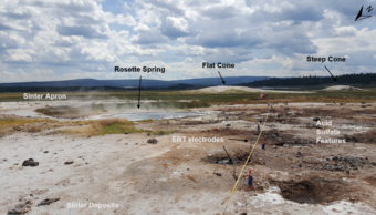
The University of Wyoming has been using ground-based geophysical methods for a decade to image the “plumbing systems” below hot springs and geysers in Yellowstone. In 2018, a group of students hiked 2 miles with an extensive and very heavy collection of geophysical equipment to collect multiple types of subsurface images beneath Sentinel Meadows, a hydrothermally active drainage in Lower Geyser Basin. One data set targeted the plumbing system beneath Rosette Spring (aka Bison Pool) using electrical resistivity tomography (ERT). Hydrothermal water is electrically conductive (meaning that there is less resistance to the flow of electric charge), which makes this method very effective at imaging hydrothermal water in the subsurface—areas of low resistivity are likely to mark zones with lots of hydrothermal water. The students and instructors laid out five parallel lines of electrical sensors across Rosette Spring to measure the resistivity of the subsurface, which yielded an image of the hydrothermal waters below the ground without requiring any drilling or other damage.
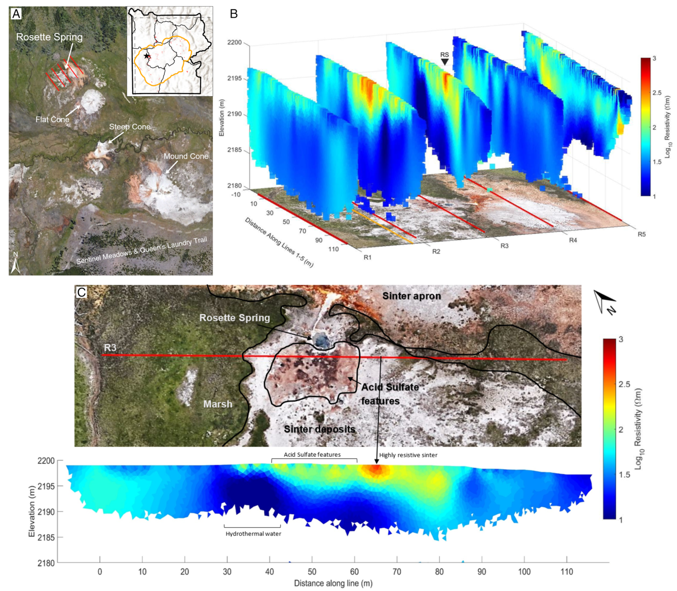
Interestingly, results from the ERT survey show that there is hydrothermal water near Rosette Spring about 5–10 meters (16–33 feet) down, but that there is no distinct pipe or conduit leading to the pool at the surface. This leads to the important conclusion that the hydrothermal water feeding the pool likely travels through a dense network of small pathways in the glacial deposits that make up the surface geology in the area. Such pathways are so small that they are hard to see with the equipment that the field team used. Additionally, the ERT line nearest to Rosette Spring shows a more resistive signal indicative of white sinter deposits that are created by the hot spring waters cooling and precipitating silica. This demonstrates that the white sinter deposits seen at the surface extend into the subsurface to a depth of about 7 meters (23 feet). Because the ERT image does not show a resolvable conduit or pipe-like structure from deeper water to the surface, it remains a mystery as to how Rosette Spring gets its water, and research continues into how hydrothermal waters travel from deep reservoirs and emerge as hot springs in Yellowstone. New high-resolution geophysical data will undoubtedly continue to provide insights into these and other fundamental questions about Yellowstone’s hot water plumbing systems!