
Novel technique peeks beneath the ground at Yellowstone’s hot water plumbing system
What do the subsurface fluid pathways look like for all of the hot springs and geysers scattered throughout Yellowstone? A new set of data from an aerial electromagnetic survey provides a new perspective on this age-old question.
Yellowstone Caldera Chronicles is a weekly column written by scientists and collaborators of the Yellowstone Volcano Observatory. This week's contribution is from Carol Finn and Paul Bedrosian, research geophysicists with the U.S. Geological Survey.
Old Faithful, Grand Prismatic Spring, Mammoth Hot Springs, Steamboat Geyser, and Mud Volcano are just a few of the over 10,000 active hydrothermal features formed by the interaction of ground water with the heat from the magmatic system beneath Yellowstone Caldera. While these enthralling features are enjoyed by millions of visitors every year, the underground plumbing system that feeds them is mostly hidden from view. Where does the hot water come from, and where does it go? Such information might tell us in general why surface thermal features are located where they are.
Yellowstone's hydrothermal plumbing system results from several factors. The water from high precipitation (snow and rain) penetrates 4–5 kilometers (2.5–3.1 miles) deep along the many faults in the region. These deep waters are heated by magma and hot rock, forcing them to return to the surface much like “lava” in a lava lamp. This vast underground plumbing system ultimately feeds the iconic thermal features, where much is known about their temperature and chemistry. In contrast, little was known about how the surface features are connected to each other and deeper sources of fluids. Until now.

In 2016, a technique called airborne electromagnetics (AEM) was used to measure the physical properties of ground beneath Yellowstone. AEM takes advantage of water being a much better electrical conductor than rock, and that this difference between wet and dry rock can be detected by a sensitive electromagnet to depths of 150–700 meters (500–2300 feet). The technology is a larger version of that used in induction stoves or wireless cell phone chargers. The AEM instrument, mounted on a hoop that is 15–25 meters (50–80 feet) across and dangles beneath a low-flying helicopter, detected these variations in detail, like a medical cat scan uses data from a set of surface detectors to “see” inside a human body.
In most volcanic hydrothermal systems, characteristic sequences of hydrothermal clays reveal fluid or gas conduits along faults and fractures that can also be detected from the air. To map these clays below the depth resolution of the AEM, down to about 3 kilometers (1.9 miles), an additional instrument was employed—one that senses variations in the magnetic properties of rocks. Clays are less magnetic than volcanic rocks, making this difference relatively easy to detect.
For several weeks, the helicopter flew back and forth across Yellowstone to measure variations in these electric and magnetic properties, in the process revealing clues about Yellowstone’s hydrothermal plumbing system. These techniques are highly effective in environments like Yellowstone, where strong contrasts in the electrical conductivity of cold groundwater, thermal fluids, and dry volcanic rocks can be exploited. Additionally, thermal fluids alter the rocks they pass through, turning rock into clay minerals which have low electrical resistivity and subdued magnetization. But flying the survey was only part of the challenge. Translating all that data into something tangible required years of painstaking work!
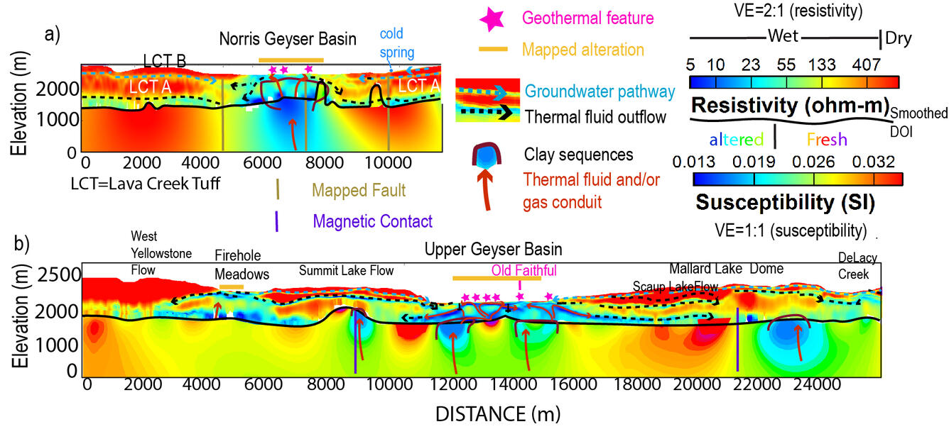
The instrument responses were analyzed to produce detailed cross-sections along the flight lines, as well as depth maps from resistivity and susceptibility models. The models show that most thermal features are located above low-resistivity and low-magnetic-susceptibility clay-capped buried faults and fractures that channel fluids and gases from depth. Shallow sub-horizontal pathways between ancient lava flows contribute groundwater into the system, which mixes with thermal fluids from the channels. As fluids approach the surface, local constrictions induce boiling, degassing, or conductive cooling that produce the diversity of thermal features at Yellowstone.
Due to its resolution, capable of detecting features on the order of 100 meters (330 feet) in size, the AEM system cannot directly image the narrow fluid-flow paths to specific geysers and hot springs. By way of analogy, this would be like imaging a city’s water supply and distribution lines but not the lines feeding individual houses. Despite their diversity, the fluid flow paths to most thermal features are similar across Yellowstone, suggesting that local, rather than regional, conditions control the chemistry and style of geysers, mud pools and hot springs. The new models, however, provide a regional framework for focused geophysical and geochemical studies of the individual thermal features.
This work, published recently in the journal Nature, fills in a longstanding gap in knowledge about the underpinnings of Yellowstone’s charismatic hydrothermal features and has sparked considerable interest across a range of disciplines. This includes microbiologists looking to link areas of groundwater and gas mixing to regions of extreme microbiological diversity, geologists using the models to map lava flows and estimate eruptive volumes, hydrologists interested in incorporating flow paths and regions of groundwater and thermal water into geochemical fluid evolution models, and economic geologists interested in Yellowstone as a modern analogue for epithermal mineral deposits. The full potential of these new airborne geophysical data are just beginning to be realized!
Additional reading:
Finn, C.A., Bedrosian, P.A., Holbrook, W.S., Auken, E., Bloss, B.R., and Crosbie, J., 2022, Geophysical imaging of the Yellowstone hydrothermal plumbing system. Nature 603, 643–647. https://doi.org/10.1038/s41586-021-04379-1
Finn, C.A., and Bedrosian, P.A, 2022, Imaging Yellowstone’s plumbing from the sky. Nature Research Brief 603. https://doi.org/10.1038/d41586-022-00745-9