
Pennsylvania Waters - Fall 2024 - Issue 13

Drought Watch Expanded to 40 Pennsylvania Counties
USGS groundwater and surface water monitoring data contributed to the Pennsylvania Department of Environmental Protection's (PaDEP) January 8, 2026, expansion of drought watches to three additional counties. A total of 40 counties are now under drought watch, and one county under a warning.
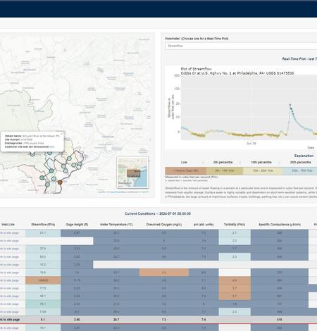
USGS Updates Philadelphia Water Resources Monitoring Web Tool
USGS, in cooperation with the Philadelphia Water Department, updated the Philadelphia Water Resources Monitoring Web Tool.
USGS Releases Geonarratives Documenting Monitoring Activities in Chester County, Pennsylvania
The USGS has had a cooperative program with Chester County since 1969 to measure and describe water resources in the county. Cooperation has been primarily with the Chester County Water Resources Authority, with participation from the Chester County Health Department. This partnership provides Chester County with scientific information for water-resources management.
USGS Releases Geonarrative Documenting Results of Pesticide Sampling in Pennsylvania Groundwater
USGS, in cooperation with the Pennsylvania Department of Agriculture (PDA), has released a geonarrative detailing the sampling of pesticides in Pennsylvania’s groundwater

Using a time-of-travel sampling approach to quantify per- and polyfluoroalkyl substances (PFAS) stream loading and source inputs in a mixed-source, urban catchment
Understanding per- and polyfluoroalkyl substances (PFAS) mass distribution in surface and groundwater systems can support source prioritization, load reduction, and water management. Thirteen sites within an urban catchment were sampled utilizing a time-of-travel sampling approach to minimize the influence of subdaily fluctuations in mass from PFAS point sources and to quantify PFAS and...

USGS article featured on the cover of the July/August issue of Journal of Environmental Quality
A USGS fieldwork photo was recently featured on the cover of the July/August 2024 issue of Journal of Environmental Quality*. The issue includes the article Complex Hydrology and Variability of Nitrogen Sources in a Karst Watershed authored by scientists from the USGS Pennsylvania Water Science Center and the University of Kansas.
Bill Werkheiser Selected as Associate Director for the Water Resources Mission Area
The U.S. Geological Survey is pleased to announce the selection of Bill Werkheiser as the new Associate Director (AD) for the Water Resources Mission Area (WMA), starting Monday, July 15th.
Millions in the U.S. may rely on groundwater contaminated with PFAS for drinking water supplies
PEMBROKE, N.H. — Approximately 71 to 95 million people in the Lower 48 states – more than 20% of the country’s population – may rely on groundwater that contains detectable concentrations of per- and polyfluoroalkyl substances, also known as PFAS, for their drinking water supplies. These findings are according to a U.S Geological Survey study published Oct. 24.
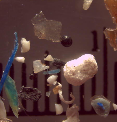
Small particles, big problems: A strategy for addressing microplastics science gaps
Learn more about the new strategy for current and future USGS microplastics research.
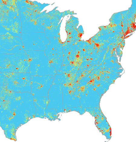
Predictive modeling reveals elevated conductivity relative to background levels in freshwater tributaries within the Chesapeake Bay watershed, USA
Elevated conductivity (i.e., specific conductance or SC) causes osmotic stress in freshwater aquatic organisms and may increase the toxicity of some contaminants. Indices of benthic macroinvertebrate integrity have declined in urban areas across the Chesapeake Bay watershed (CBW), and more information is needed about whether these declines may be due to elevated conductivity. A...

Calibration data and model archive summaries for suspended-sediment, total nitrogen, and total phosphorus concentration surrogate models at USGS station 01575900, Chiques Creek near Marietta, Pennsylvania, 2021-2023
The U.S. Geological Survey (USGS), in cooperation with the U.S. Department of Agriculture Natural Resources Conservation Service (USDA NRCS) has collected discrete stream samples for analysis of suspended-sediment, total nitrogen, and total phosphorus at the real-time streamflow and water-quality monitoring (turbidity and nitrate) station 01575900, Chiques Creek Near Marietta...
Population genetic structure and demographic history reconstruction of introduced flathead catfish (Pylodictis olivaris) in two US Mid-Atlantic rivers
Population genetic analysis of invasive populations can provide valuable insights into the source of introductions, pathways for expansion, and their demographic histories. Flathead catfish (Pylodictis olivaris) are a prolific invasive species with high fecundity, long-distance dispersal, and piscivorous feeding habits that can lead to declines in native fish populations. In this study...
@usgs_pa - Recent Instagram* posts
- Thank You Veterans!
- Fall Field Photos
- Delaware River Fest
- New Streamgage in Adams County
- and more @usgs_pa
*Any use of trade, firm, or product names is for descriptive purposes only and does not imply endorsement by the U.S. Government.