
Water Management Decision Support in the Red River Basin
In the Spotlight
The South Central CASC's Red River work was featured on an Environmental and Energy Study Institute (EESI) podcast.
The combination of drought and increasing water demands are stressing water resources in the Red River Basin of Oklahoma and Texas. USGS-supported scientists have developed decision support tools to identify the most cost-effective water conservation alternatives across the Red River basin. The models help resource managers identify conservation strategies that maximize outcomes for Great Plains stream ecosystems while meeting growing societal water needs.
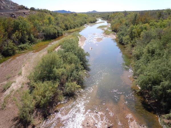
The Red River Basin is a vital source of water in the South Central U.S., supporting ecosystems, drinking water, agriculture, tourism and recreation, and cultural ceremonies. Stretching from the High Plains of New Mexico eastward to the Mississippi River, the Red River Basin encompasses parts of five states – New Mexico, Texas, Oklahoma, Arkansas, and Louisiana. Further, 74% of the jurisdictional boundaries of the Chickasaw and Choctaw Tribes are located within the basin.
Water resources in the basin have been stressed in recent years due to a multi-year drought and increasing demands for consumptive use by metropolitan areas in Oklahoma and Texas.
The USGS South Central Climate Adaptation Science Center (South Central CASC) supports research to understand how climate change is impacting water resources in the Red River Basin and develops tools to inform water management in the area.
Impacts of Climate Change on Water Flows in the Red River Basin
With USGS funding, researchers at the University of Oklahoma and the Choctaw and Chickasaw Nations developed projections of future stream conditions for the Red River Basin under possible future climate conditions.
Their models indicated that the Red River Basin will be warmer in the future, with average temperatures potentially increasing by as much as 6°C (11°F) under worst-case greenhouse gas emissions scenarios. Nighttime temperatures are expected to increase more than daytime temperatures. There is also strong possibility that future droughts will be longer and deeper across the entire basin, while floods may be more intense.
Climate-Informed Decision Support in the Red River Basin
Researchers incorporated USGS-supported climate projections into decision support models to identifying cost-effective water conservation strategies across the Red River basin. The optimization model provides resource managers with a means to identify conservation strategies that maximize outcomes for Great Plains stream ecosystems while meeting growing societal needs for water.
These enhanced models, originally funded by the Great Plains Landscape Conservation Cooperative (LCC), help managers and decision makers to:
- Visualize and evaluate multiple competing water use scenarios under future drought conditions.
- Visualize potential future distributions of fish species of conservation concern across the Red River, enabling them to proactively manage species projected to be at greatest risk from declining water availability.
- Quantify trade-offs between competing water uses and ecological outcomes under multiple use scenarios.

Evaluating the Impacts of Potential Wastewater Reuse on Streams in the Red River Basin of Oklahoma

Balancing Water Usage and Ecosystem Outcomes Under Drought and Climate Change: Enhancing an Optimization Model for the Red River

Informing Hydrologic Planning in the Red River Valley through Improved Regional Climate Projections

Impacts of Climate Change on Water Flows in the Red River Basin
The combination of drought and increasing water demands are stressing water resources in the Red River Basin of Oklahoma and Texas. USGS-supported scientists have developed decision support tools to identify the most cost-effective water conservation alternatives across the Red River basin. The models help resource managers identify conservation strategies that maximize outcomes for Great Plains stream ecosystems while meeting growing societal water needs.
The Red River Basin is a vital source of water in the South Central U.S., supporting ecosystems, drinking water, agriculture, tourism and recreation, and cultural ceremonies. Stretching from the High Plains of New Mexico eastward to the Mississippi River, the Red River Basin encompasses parts of five states – New Mexico, Texas, Oklahoma, Arkansas, and Louisiana. Further, 74% of the jurisdictional boundaries of the Chickasaw and Choctaw Tribes are located within the basin.
Water resources in the basin have been stressed in recent years due to a multi-year drought and increasing demands for consumptive use by metropolitan areas in Oklahoma and Texas.
The USGS South Central Climate Adaptation Science Center (South Central CASC) supports research to understand how climate change is impacting water resources in the Red River Basin and develops tools to inform water management in the area.
Impacts of Climate Change on Water Flows in the Red River Basin
With USGS funding, researchers at the University of Oklahoma and the Choctaw and Chickasaw Nations developed projections of future stream conditions for the Red River Basin under possible future climate conditions.
Their models indicated that the Red River Basin will be warmer in the future, with average temperatures potentially increasing by as much as 6°C (11°F) under worst-case greenhouse gas emissions scenarios. Nighttime temperatures are expected to increase more than daytime temperatures. There is also strong possibility that future droughts will be longer and deeper across the entire basin, while floods may be more intense.
Climate-Informed Decision Support in the Red River Basin
Researchers incorporated USGS-supported climate projections into decision support models to identifying cost-effective water conservation strategies across the Red River basin. The optimization model provides resource managers with a means to identify conservation strategies that maximize outcomes for Great Plains stream ecosystems while meeting growing societal needs for water.
These enhanced models, originally funded by the Great Plains Landscape Conservation Cooperative (LCC), help managers and decision makers to:
- Visualize and evaluate multiple competing water use scenarios under future drought conditions.
- Visualize potential future distributions of fish species of conservation concern across the Red River, enabling them to proactively manage species projected to be at greatest risk from declining water availability.
- Quantify trade-offs between competing water uses and ecological outcomes under multiple use scenarios.
Evaluating the Impacts of Potential Wastewater Reuse on Streams in the Red River Basin of Oklahoma
Balancing Water Usage and Ecosystem Outcomes Under Drought and Climate Change: Enhancing an Optimization Model for the Red River
Informing Hydrologic Planning in the Red River Valley through Improved Regional Climate Projections