
Data
Browse real-time data, data releases, software/code releases and more.
Filter Total Items: 194
Niche model results predicting fundamentally suitable and unsuitable habitat for freshwater mussel concentrations in the Meramec Basin Niche model results predicting fundamentally suitable and unsuitable habitat for freshwater mussel concentrations in the Meramec Basin
This layer represents fundamentally suitable and unsuitable habitat for freshwater mussels in the Meramec Basin as modeled by these authors on May 17, 2017 based on spatial data ranging from 1990 to 2014. Identification of habitat characteristics associated with the presence of freshwater mussels is challenging but crucial for the conservation of this declining fauna. Most mussel species...
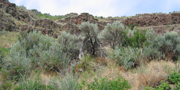
Spatial covariance tracks grassland bird community occupancy in fragmented grasslands Spatial covariance tracks grassland bird community occupancy in fragmented grasslands
Grasslands are an imperiled ecosystem, and grassland bird abundance is declining across North America. One of the strongest drivers for these declines is woody plant encroachment of grasslands. In the Great Plains and Sagebrush biomes of North America, spatial covariance—a remote sensing metric for tracking boundaries between vegetation types—is emerging as a new method to identify and...
Nine-banded armadillo and coyote detection data and site-specific data from the Wichita Mountains Wildlife Refuge during summer 2023 Nine-banded armadillo and coyote detection data and site-specific data from the Wichita Mountains Wildlife Refuge during summer 2023
This dataset includes (i) camera-based detection data for nine-banded armadillos (Dasypus novemcinctus) and coyotes (Canis latrans) and (ii) covariates characterizing the environmental conditions at each of 100 sites sampled in the Wichita Mountains Wildlife Refuge during summer 2023.
Spatial Occupancy Patterns of the Endangered Northern Long-eared Bat in New England Spatial Occupancy Patterns of the Endangered Northern Long-eared Bat in New England
These are the northern long-eared bat (Myotis septentrionalis) summer month occupancy values derived from acoustic sampling and associated collection site environmental and weather covariates for the New England region, United States, 2015-2022.
Bird point count and vegetation survey data from grassland sites in southern Iowa Bird point count and vegetation survey data from grassland sites in southern Iowa
This dataset contains records from bird point count and vegetation surveys conducted at 71 sites in southern Iowa in 2022 and 2023. All sites had recently implemented a management practice aimed at increasing habitat quality for northern bobwhite. We conducted surveys at 1-3 points per site and visited each point 3 times between May 15 and July 31 each year. Some sites were visited in...
Electrofishing, environmental DNA, and habitat data for watercourses in the Goose Lake Basin, Oregon, U.S.A., 2022–2024 Electrofishing, environmental DNA, and habitat data for watercourses in the Goose Lake Basin, Oregon, U.S.A., 2022–2024
We collected electrofishing, environmental DNA (eDNA), and habitat data from 2022 to 2024 in the Oregon portion of the Goose Lake Basin. Data were collected by the U.S. Geological Survey (USGS) and Oregon State University (OSU) to monitor native and non-native fish distributions in the Basin, and to relate observed abundances to specific habitat features. Sampling was conducted in...
Current geographic distribution of nine-banded armadillos in the United States Current geographic distribution of nine-banded armadillos in the United States
These data are associated with occurrences of nine-banded armadillos across the United States. There are associated biological and environmental variables associated with some of the occurrence data. These were used for a species distribution model.
Moose Health and Parasitic Threats in New York Moose Health and Parasitic Threats in New York
This dataset includes all research conducted on moose health in New York State from 2021 to 2024. Files include detection histories of moose and other species from camera surveys conducted in the northern Adirondack Park, transect surveys conducted for deer pellet collection and analysis of parasite infection status, and step length measurements of GPS-collared moose. Other files and...
Avian occupancy and habitat data in Georgia pine savannas in 2022 Avian occupancy and habitat data in Georgia pine savannas in 2022
This dataset includes information on detections of Bachman's Sparrow, Northern Bobwhite, and Red-cockaded Woodpecker at 161 locations in Georgia, USA. In addition to detections of birds and corresponding detection covariates (date, time, temperature, and observer), habitat metrics derived from satellite imagery and on-the-ground vegetation measurements are included.
Data for Fatal interactions: Pneumonia in bighorn lambs following experimental exposure to carriers of Mycoplasma ovipneumoniae Data for Fatal interactions: Pneumonia in bighorn lambs following experimental exposure to carriers of Mycoplasma ovipneumoniae
We hypothesized that bighorn sheep ewes with chronic nasal Mycoplasma ovipneumoniae carriage are the source of infection that results in fatal lamb pneumonia. We tested this hypothesis in captive bighorn ewes at two study facilities over a 5-year period, by identifying carrier ewes and then comparing lamb fates in groups that did (exposed pens) or did not (non-exposed pens) include one...
Watershed Level Occurrences of Yellow Lampmussel from Museum and Survey Data Watershed Level Occurrences of Yellow Lampmussel from Museum and Survey Data
Natural history museum records may provide unique information on the distribution of species additional to survey data collected by resource managers. However, there can be challenges to using museum data for analyses such as spurious geographic information, misidentifications, and incorrect labeling. Museum records have been centralized by open-source repositories with flags for...
Water quality of the Jim Bertram Lake System, Lubbock, Texas: Oct 2021-Oct 2023 Water quality of the Jim Bertram Lake System, Lubbock, Texas: Oct 2021-Oct 2023
Data are found in two separate *.csv files. File 1 contains the data and file 2, the sampling site coordinates. The data describes the results of water quality measurements in the Jim Bertram Lake System, an impounded urban stream system in Lubbock, Texas. Measurements were taken from October 2021 through October 2023.