
Cool Earthquake Facts
Find some interesting facts about earthquakes.
Media

Sources/Usage: Public Domain. View Media Details
- The largest recorded earthquake in the United States was a magnitude 9.2 that struck Prince William Sound, Alaska on Good Friday, March 28, 1964 UTC.
- The largest recorded earthquake in the world was a magnitude 9.5 (Mw) in Chile on May 22, 1960.
- The earliest reported earthquake in California was felt in 1769 by the exploring expedition of Gaspar de Portola while the group was camping about 48 kilometers (30 miles) southeast of Los Angeles.
- Before electronics allowed recordings of large earthquakes, scientists built large spring-pendulum seismometers in an attempt to record the long-period motion produced by such quakes. The largest one weighed about 15 tons. There is a medium-sized one three stories high in Mexico City that is still in operation.
Media

Sources/Usage: Public Domain. View Media Details
- The fastest wave, and therefore the first to arrive at a given location, is called the P wave. The P wave, or compressional wave, alternately compresses and expands material in the same direction it is traveling.
- The average rate of motion across the San Andreas Fault Zone during the past 3 million years is 56 mm/yr (2 in/yr). This is about the same rate at which your fingernails grow. Assuming this rate continues, scientists project that Los Angeles and San Francisco will be adjacent to one another in approximately 15 million years.
Media

Sources/Usage: Public Domain. View Media Details
- The East African Rift System is a 50-60 km (31-37 miles) wide zone of active volcanics and faulting that extends north-south in eastern Africa for more than 3000 km (1864 miles) from Ethiopia in the north to Zambezi in the south. It is a rare example of an active continental rift zone, where a continental plate is attempting to split into two plates which are moving away from one another.
- The first “pendulum seismoscope” to measure the shaking of the ground during an earthquake was developed in 1751, and it wasn’t until 1855 that faults were recognized as the source of earthquakes.
- Moonquakes (“earthquakes” on the moon) do occur, but they happen less frequently and have smaller magnitudes than earthquakes on the Earth. It appears they are related to the tidal stresses associated with the varying distance between the Earth and Moon. They also occur at great depth, about halfway between the surface and the center of the moon.
- Although both are sea waves, a tsunami and a tidal wave are two different unrelated phenomenona. A tidal wave is a shallow water wave caused by the gravitational interactions between the Sun, Moon, and Earth. A tsunami is a sea wave caused by an underwater earthquake or landslide (usually triggered by an earthquake) displacing the ocean water.
- The hypocenter of an earthquake is the location beneath the earth’s surface where the rupture of the fault begins.
- The epicenter of an earthquake is the location directly above the hypocenter on the surface of the earth.
Media

Sources/Usage: Public Domain. View Media Details
- The “Ring of Fire” also called the Circum-Pacific belt, is the zone of earthquakes surrounding the Pacific Ocean — about 90% of the world’s earthquakes occur there. The next most seismic region (5-6% of earthquakes) is the Alpide belt (extends from Mediterranean region, eastward through Turkey, Iran, and northern India.
- It is estimated that there are 500,000 detectable earthquakes in the world each year. 100,000 of those can be felt, and 100 of them cause damage.
- It is thought that more damage was done by the resulting fire after the 1906 San Francisco earthquake than by the earthquake itself.
- A seiche (pronounced SAYSH) is what happens in the swimming pools of Californians during and after an earthquake. It is “an internal wave oscillating in a body of water” or, in other words, it is the sloshing of the water in your swimming pool, or any body of water, caused by the ground shaking in an earthquake. It may continue for a few moments or hours, long after the generating force is gone. A seiche can also be caused by wind or tides.
- Each year the southern California area has about 10,000 earthquakes. Most of them are so small that they are not felt. Only several hundred are greater than magnitude 3.0, and only about 15-20 are greater than magnitude 4.0. If there is a large earthquake, however, the aftershock sequence will produce many more earthquakes of all magnitudes for many months.
- The magnitude of an earthquake is a measured value of the earthquake size. The magnitude is the same no matter where you are, or how strong or weak the shaking was in various locations. The intensity of an earthquake is a measure of the shaking created by the earthquake, and this value does vary with location.
Media
Sources/Usage: Public Domain. View Media Details
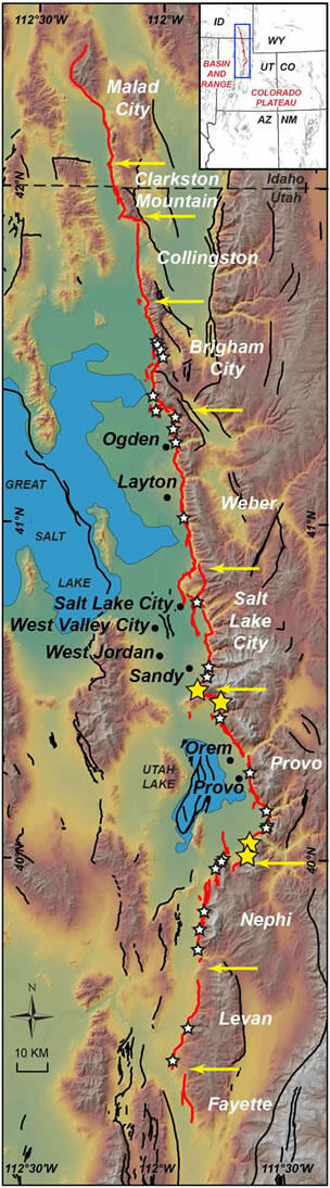
- The Wasatch Range, with its outstanding ski areas, runs North-South through Utah, and like all mountain ranges it was produced by a series of earthquakes. The 386 km (240-mile)-long Wasatch Fault is made up of several segments, each capable of producing up to a M7.5 earthquake. During the past 6,000 years, there has been a M6.5+ about once every 350 years, and it has been about 350 years since the last powerful earthquake, which was on the Nephi segment.
- The world’s greatest land mountain range is the Himalaya-Karakoram. It countains 96 of the world’s 109 peaks of over 7,317m (24,000 ft). The longest range is the Andes of South America which is 7,564km (4700 mi) in length. Both were created by the movement of tectonic plates.
- The longest mountain range in the world, though, is the mid-ocean ridge, extending 64,374 km (40,000 mi) from the Arctic Ocean to the Atlantic Ocean, around Africa, Asia, and Australia, and under the Pacific Ocean to the west coast of North America.
- As far as we know, there is no such thing as "earthquake weather". Statistically, there is an equal distribution of earthquakes in cold weather, hot weather, rainy weather, etc. If weather does affect earthquake occurrence, we do not yet understand how it works.
- From 1975-1995 there were only four states that did not have any earthquakes. They were: Florida, Iowa, North Dakota, and Wisconsin.
- The core of the earth was the first internal structural element to be identified. In 1906 R.D. Oldham discovered it from his studies of earthquake records. The inner core is solid, and the outer core is liquid and so does not transmit the shear wave energy released during an earthquake.
- The swimming pool at the University of Arizona in Tucson lost water from sloshing (seiche) caused by the 1985 M8.1 Michoacan, Mexico earthquake 2000 km (1240 miles) away.
- Earthquakes occur in the central portion of the United States too! Some very powerful earthquakes occurred along the New Madrid fault in the Mississippi Valley in 1811-1812. Because of the crustal structure in the Central US which efficiently propagates seismic energy, shaking from earthquakes in this part of the country are felt at a much greater distance from the epicenters than similar size quakes in the Western US.
- Most earthquakes occur at depths of less than 80 km (50 miles) from the Earth’s surface.
- The San Andreas fault is NOT a single, continuous fault, but rather is actually a fault zone made up of many segments. Movement may occur along any of the many fault segments along the zone at any time. The San Andreas fault system is more that 1300 km (800 miles) long, and in some spots is as much as 16 km (10 miles) deep.
- The origin of the name of the San Andreas Fault is often cited as the San Andreas Lake. However, based on some 1895 and 1908 reports by geologist A.C. Lawson, who named the fault, the name was actually taken from the San Andreas Valley. He likely did not realize at the time that the fault ran almost the entire length of California!
- The world’s deadliest recorded earthquake occurred in 1556 in central China. It struck a region where most people lived in caves carved from soft rock. These dwellings collapsed during the earthquake, killing an estimated 830,000 people. In 1976 another deadly earthquake struck in Tangshan, China, where more than 250,000 people were killed.
- Florida and North Dakota have the smallest number of earthquakes in the United States.
- The deepest earthquakes typically occur at plate boundaries where the Earth”s crust is being subducted into the Earth’s mantle. These occur as deep as 750 km (400 miles) below the surface.
Media

Sources/Usage: Public Domain. View Media Details
- Alaska is the most earthquake-prone state and one of the most seismically active regions in the world. Alaska experiences a magnitude 7 earthquake almost every year, and a magnitude 8 or greater earthquake on average every 14 years.
- The majority of the earthquakes and volcanic eruptions occur along plate boundaries such as the boundary between the Pacific Plate and the North American plate. One of the most active plate boundaries where earthquakes and eruptions are frequent, for example, is around the massive Pacific Plate commonly referred to as the Pacific Ring of Fire.
- The earliest recorded evidence of an earthquake has been traced back to 1831 BC in the Shandong province of China, but there is a fairly complete record starting in 780 BC during the Zhou Dynasty in China.
- It was recognized as early as 350 BC by the Greek scientist Aristotle that soft ground shakes more than hard rock in an earthquake.
Media

Sources/Usage: Public Domain. View Media Details
- The cause of earthquakes was stated correctly in 1760 by British engineer John Michell, one of the first fathers of seismology, in a memoir where he wrote that earthquakes and the waves of energy that they make are caused by “shifting masses of rock miles below the surface”.
- Subduction is the process of the oceanic lithosphere colliding with and descending beneath the continental lithosphere.
- In 1663 the European settlers experienced their first earthquake in America.
- Human beings can detect sounds in the frequency range 20-20,000 Hertz. If a P wave refracts out of the rock surface into the air, and it has a frequency in the audible range, it will be heard as a rumble. Most earthquake waves have a frequency of less than 20 Hz, so the waves themselves are usually not heard. Most of the rumbling noise heard during an earthquake is from buildings and their contents moving.
- When the Chilean earthquake occurred in 1960, seismographs recorded seismic waves that traveled all around the Earth. These seismic waves shook the entire earth for many days! This phenomenon is called the free oscillation of the Earth.
- The interior of Antarctica has icequakes which, although they are much smaller, are perhaps more frequent than earthquakes in Antarctica. The icequakes are similar to earthquakes, but occur within the ice sheet itself instead of the land underneath the ice. Some of our polar observers have told us they can hear the icequakes and see them on the South Pole seismograph station, but they are much too small to be seen on enough stations to obtain a location.
- On January 26, 1700 at about 9 PM Pacific time, the largest known earthquake in the continental U.S. occurred. We know the time so precisely because Japan has been recording tsunamis at least as far back as 684 CE, and this large Cascadia earthquake caused a tsunami that Japan recorded. We can work backwards from the time the tsunami arrived in Japan to determine when the earthquake happened.
Media

Sources/Usage: Public Domain. View Media Details
- The present-day location of The Pinnacles is 195 mi (314 km) northwest from the volcano that the San Andreas sliced it from. We know these volcanic rocks are 23 million years old. That means the San Andreas fault has moved 0.59 in/yr (1.5 cm/yr) over the last 23 million years.