



Reading the Potomac, Preparing a Nation: What Washington's Forgotten Floods Reveal
By combining streamgage records, historic accounts, and geologic evidence, USGS scientists are uncovering centuries of flood history to help communities better understand risk and build resilience.
Like many cities on the East Coast, Washington, D.C. sits at the ‘Fall Line,’ a geologic boundary where the harder rocks of the Piedmont meet the softer sediments of the Atlantic Coastal Plain. Here, the Potomac River drops sharply, forming waterfalls and rapids at Little Falls before gradually widening into a tidal estuary as it flows through Washington. This location makes the low-lying portions of the city vulnerable to flooding from both heavy precipitation in the Potomac River watershed and coastal storm surge moving up the estuary during hurricanes and nor’easters.
Although these modern flood hazards are well documented, understanding how the Potomac River behaves during its most extreme floods requires looking beyond recent observations and into the past several centuries.
Reconstructing Washington’s Flood History
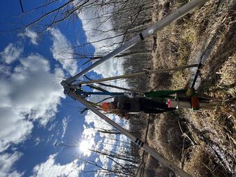
To extend Washington’s flood record beyond modern instrumental records, USGS scientists combined USGS streamgage records, National Oceanic and Atmospheric Administration tide-gauge observations, information found in historic archives dating back to the late 1700s, and geologic evidence preserved in sediment cores spanning nearly 500 years.
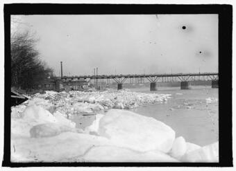
Researchers found evidence that ice-jam flooding during the Little Ice Age produced some of the largest floods in Washington’s history. One such event occurred in March 1784. Following a severe winter, ice moving downstream encountered a frozen estuary, creating a massive ice jam near Georgetown. The ice jam was eventually breached during a rain-on-snow event in the watershed, resulting in a flood that was approximately twice as large as any on record within the past two centuries in Washington.
Researchers also found that flooding became more frequent after the mid-1800s, with many of the largest floods occurring between about 1870 and 1945. This period coincided with changes to forest cover in the watershed, human modifications to the river, and heavier rainfall events.
Preparing for Future Floods
Washington, D.C. faces one of the highest 100‐year flood risks of any major city along the U.S. East Coast. Understanding the magnitude and drivers of past flooding events can help managers prepare for future events in the region. By bringing together information from this wide range of sources, researchers were able to identify flood risks and extreme events that would not have been apparent from modern observations alone. While roads, waterfront infrastructure, and public spaces are often designed around 100-year flood estimates, the results of this work show that flood behavior on the Potomac River is dynamic, with factors such as land-use change and shifts in storm frequency influencing the magnitude of flood waters and how they move through the city. This information can help inform management decisions regarding land-use practices to limit runoff and the potential need to bolster waterfront structures against future flooding.
The research team is also actively engaged with the U.S. Army Corps of Engineers, the D.C. Department of Energy and Environment, and other partners, as part of an effort to synthesize a comprehensive database of historic flood events in the District that would be accessible to the general public.
Supporting a Hazard Ready Nation
While this work is focused on Washington, D.C., its lessons extend far beyond the nation’s capital. Communities across the U.S. are facing difficult decisions about water security, infrastructure resilience, and hazard mitigation. Evaluating hazards through a lens that combines both the recent and geologic past can provide a more complete understanding of the range and severity of natural hazards. Whether confronting flooding in the Mid-Atlantic, drought in the West, hurricanes along the Gulf Coast, wildfires in the Rockies, or coastal change in Alaska, a long-term perspective can help communities better assess risk and strengthen preparedness.
Read the paper: Toomey, M., Cronin, T., Rodysill, J., Seidenstein, J., & Willard, D. (2026). Extreme Potomac Floods at Washington DC During the Past 500 Years. Geophysical Research Letters, 53(2), e2025GL118329. https://doi.org/10.1029/2025GL118329