
The Mineral Resources Program is the Nation’s primary provider of impartial estimates of known and undiscovered mineral resources. We study the full life cycle of mineral commodities, including critical minerals, to inform decisions about where and how to develop mineral resources.
Explore our Mineral Resource Assessments

We estimate regional, national and global mineral resources.
The Mineral Systems Map

This map shows areas with potential for groups of minerals and is a tool for targeting future data collection.
The Power of Machine Learning

Through the CriticalMAAS project, the Mineral Resources Program and DARPA have partnered to accelerate mineral resource assessments with the power of machine learning.
We are the Nation's primary source for assessments of domestic and global mineral resources.
Who Uses Mineral Assessments?
Mineral resource assessments estimate the location, quantity and quality of known and undiscovered mineral resources. Decision-makers rely on mineral assessments to understand how much mineral resources might be available domestically versus globally, where future mineral development could take place, and how that mineral development could impact other natural resources. This includes:
- Government agencies, like the U.S. Geological Survey (USGS), who use them to inform national resource planning and policy.
- Exploration and mining companies, who rely on assessments to decide where to explore and invest.
- Land and resource managers, who use the information to balance mining with environmental protection and land use.
- Researchers and scientists, who study how minerals form and where they might be found.
- Lawmakers and decision-makers, who need accurate data to support economic development and critical mineral supply chains.
Our mineral assessments inform trade strategies, sustainable resource management and the investment of billions of dollars.
How do we estimate undiscovered mineral resources?
Mineral resource assessments are built on foundational research; by studying the geologic processes that result in known mineral deposits, we can better predict where undiscovered resources might be. By combining this research with high-quality geophysical, geochemical and geologic data, we identify locations where the correct combination of geologic processes may have occurred to produce a mineral deposit. We do this through both qualitative and quantitative assessments. Qualitative 3-part assessments are designed to evaluate the occurrence, distribution, and potential resources of critical minerals while quantitative prospectivity mapping identifies regions' mineral potential through data-driven mapping.
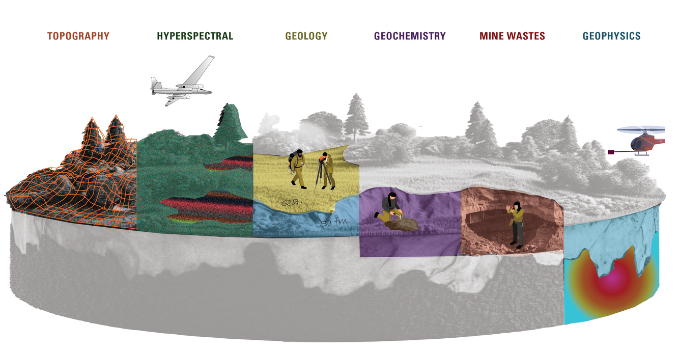
We continuously improve our mineral assessment process by doing research to better understand key deposit-forming geologic processes. We also collect high-resolution geophysical, geochemical and geologic data to better identify locations where these processes may have resulted in mineral deposits. These data types include:
- Geological: Information about rock types, stratigraphy, structure, and geological history.
- Geochemical: Analyses of soil, rock, and water samples to identify the presence and concentration of minerals and elements.
- Geophysical: Measurements of physical properties of the earth, such as magnetic, gravitational, electrical, and seismic data, to help identify mineral deposits.
- Mining and production: Historical data on mining operations, production statistics, and economic factors related to mineral extraction.
- Environmental: Information on environmental conditions, land use, and potential impacts of mining activities.
- Topographic and spatial: Geographic Information System (GIS) data for mapping, land use planning, and spatial analysis.
- Remote sensing: Satellite imagery and aerial photography to observe geological features and surface conditions.
- Exploration: Results from drilling, sampling, and testing carried out during exploration activities.
- We are also exploring ways of leveraging advances in machine learning to speed up mineral assessments.
These data types help provide a comprehensive understanding of mineral potential in a study area, facilitating effective mineral assessments. Learn more about these methods here.
The United States currently lacks the data to fully understand the Nation’s mineral resources and address its changing mineral needs. We are working to change that.
Compared to other developed nations, the United States is undermapped; we lack high-quality data needed to fully understand the mineral resource potential of our Nation. Through the Earth Mapping Resources Initiative (Earth MRI), we are modernizing the Nation’s mapping of geology and mineral resources. Earth MRI partners with State geological surveys, Federal agencies and industry to collect high-quality geophysical, geochemical and geologic data across the country.
These foundational data will help to identify critical and other mineral resources below the ground and in mine wastes but also have broader applications including providing crucial insights into energy and groundwater resources and natural hazards.
We support decision-making by taking a full life cycle and multi-resource approach.

We incorporate the full life cycle of mineral resources, including the impacts of mineral development on other resources, into our research. This complements and informs our mineral resource assessments, ultimately supporting holistic decision-making.
Some examples of this include providing information about where potential mineral resources overlap with other resources such as wildlife habitat, studying how mine wastes interact with water resources, and exploring the potential for recovering minerals from modern-day and legacy mine wastes.
Our research on the distribution and characteristics of mine wastes across the Nation are particularly important for understanding the impacts and potential of mineral resources at all stages of development, increasing public safety, and informing future development. Our inventory, USMIN, is the authoritative source for the locations of the most important current and historical mines and mineral deposits in the U.S. We are also conducting mine waste mapping and geochemical sampling, including through Earth MRI. Our research helps us understand the potential for recovering minerals from legacy and modern-day waste streams and the potential environmental impacts of mine wastes and recovery
The Mineral Resources Program is the Nation’s primary provider of impartial estimates of known and undiscovered mineral resources. We study the full life cycle of mineral commodities, including critical minerals, to inform decisions about where and how to develop mineral resources.
Explore our Mineral Resource Assessments
We estimate regional, national and global mineral resources.
The Mineral Systems Map
This map shows areas with potential for groups of minerals and is a tool for targeting future data collection.
The Power of Machine Learning
Through the CriticalMAAS project, the Mineral Resources Program and DARPA have partnered to accelerate mineral resource assessments with the power of machine learning.
We are the Nation's primary source for assessments of domestic and global mineral resources.
Who Uses Mineral Assessments?
Mineral resource assessments estimate the location, quantity and quality of known and undiscovered mineral resources. Decision-makers rely on mineral assessments to understand how much mineral resources might be available domestically versus globally, where future mineral development could take place, and how that mineral development could impact other natural resources. This includes:
- Government agencies, like the U.S. Geological Survey (USGS), who use them to inform national resource planning and policy.
- Exploration and mining companies, who rely on assessments to decide where to explore and invest.
- Land and resource managers, who use the information to balance mining with environmental protection and land use.
- Researchers and scientists, who study how minerals form and where they might be found.
- Lawmakers and decision-makers, who need accurate data to support economic development and critical mineral supply chains.
Our mineral assessments inform trade strategies, sustainable resource management and the investment of billions of dollars.
How do we estimate undiscovered mineral resources?
Mineral resource assessments are built on foundational research; by studying the geologic processes that result in known mineral deposits, we can better predict where undiscovered resources might be. By combining this research with high-quality geophysical, geochemical and geologic data, we identify locations where the correct combination of geologic processes may have occurred to produce a mineral deposit. We do this through both qualitative and quantitative assessments. Qualitative 3-part assessments are designed to evaluate the occurrence, distribution, and potential resources of critical minerals while quantitative prospectivity mapping identifies regions' mineral potential through data-driven mapping.
We continuously improve our mineral assessment process by doing research to better understand key deposit-forming geologic processes. We also collect high-resolution geophysical, geochemical and geologic data to better identify locations where these processes may have resulted in mineral deposits. These data types include:
- Geological: Information about rock types, stratigraphy, structure, and geological history.
- Geochemical: Analyses of soil, rock, and water samples to identify the presence and concentration of minerals and elements.
- Geophysical: Measurements of physical properties of the earth, such as magnetic, gravitational, electrical, and seismic data, to help identify mineral deposits.
- Mining and production: Historical data on mining operations, production statistics, and economic factors related to mineral extraction.
- Environmental: Information on environmental conditions, land use, and potential impacts of mining activities.
- Topographic and spatial: Geographic Information System (GIS) data for mapping, land use planning, and spatial analysis.
- Remote sensing: Satellite imagery and aerial photography to observe geological features and surface conditions.
- Exploration: Results from drilling, sampling, and testing carried out during exploration activities.
- We are also exploring ways of leveraging advances in machine learning to speed up mineral assessments.
These data types help provide a comprehensive understanding of mineral potential in a study area, facilitating effective mineral assessments. Learn more about these methods here.
The United States currently lacks the data to fully understand the Nation’s mineral resources and address its changing mineral needs. We are working to change that.
Compared to other developed nations, the United States is undermapped; we lack high-quality data needed to fully understand the mineral resource potential of our Nation. Through the Earth Mapping Resources Initiative (Earth MRI), we are modernizing the Nation’s mapping of geology and mineral resources. Earth MRI partners with State geological surveys, Federal agencies and industry to collect high-quality geophysical, geochemical and geologic data across the country.
These foundational data will help to identify critical and other mineral resources below the ground and in mine wastes but also have broader applications including providing crucial insights into energy and groundwater resources and natural hazards.
We support decision-making by taking a full life cycle and multi-resource approach.
We incorporate the full life cycle of mineral resources, including the impacts of mineral development on other resources, into our research. This complements and informs our mineral resource assessments, ultimately supporting holistic decision-making.
Some examples of this include providing information about where potential mineral resources overlap with other resources such as wildlife habitat, studying how mine wastes interact with water resources, and exploring the potential for recovering minerals from modern-day and legacy mine wastes.
Our research on the distribution and characteristics of mine wastes across the Nation are particularly important for understanding the impacts and potential of mineral resources at all stages of development, increasing public safety, and informing future development. Our inventory, USMIN, is the authoritative source for the locations of the most important current and historical mines and mineral deposits in the U.S. We are also conducting mine waste mapping and geochemical sampling, including through Earth MRI. Our research helps us understand the potential for recovering minerals from legacy and modern-day waste streams and the potential environmental impacts of mine wastes and recovery