
ScienceBase Updates - Summer 2025
Summer 2025 topics include news on upgrades in ScienceBase, usability testing for ScienceBase modernization, updates to the Metadata Wizard, a tip on showing map information on your landing page, and a featured data release.
Table of Contents
- Featured Data Release: Lead Poisoning in Bald and Golden Eagles
- ScienceBase Upgrades: An Update for Users
- Usability Testing for ScienceBase Modernization
- Did You Know? Displaying Maps on Your Landing Page
Featured Data Release: Lead Poisoning in Bald and Golden Eagles

Lead poisoning remains a significant environmental issue, affecting a wide range of wildlife species. Human activities have dramatically increased lead levels in the environment, particularly since the industrial revolution. This toxic metal can be ingested by animals through various sources, including contaminated water, soil, and food. Birds, especially scavengers and predators, are particularly vulnerable as they often consume lead fragments from spent ammunition or fishing tackle. The consequences of lead poisoning are severe, leading to neurological damage, reproductive failure, and even death. Efforts to mitigate anthropogenic lead exposure have been ongoing since the mid-1900s, yet the threat persists, posing a continuous challenge to wildlife conservation.
In a data release published in ScienceBase in 2022, Slabe and others studied lead levels in Bald and Golden Eagles across the United States. They discovered that nearly half of the eagles tested had harmful levels of lead in their bodies. Their research showed that these high lead levels could slow down the population growth of both eagle species. The related publication was published in Science, where it received widespread attention, including mentions in over 300 news outlets and three policy sources, and citations in 55 scientific articles, according to Altmetrics.
References
Slabe, V.A., Anderson, J.T., Millsap, B.A., Cooper, J.L., Harmata, A.R., Restani, M., Crandall, R.H., Bodenstein, B., Bloom, P.H., Booms, T., Buchweitz, J., Culver, R., Dickerson, K., Domenech, R., Dominguez-Villegas, E., Driscoll, D., Smith, B.W., Lockhart, M.J., McRuer, D., Miller, T.A., Ortiz, P.A., Rogers, K., Schwarz, M., Turley, N., Woodbridge, B., Finkelstein, M.E., Triana, C.A., DeSorbo, C.R., and Katzner, T.E., 2022, Lead (Pb) in Bald and Golden Eagles from 38 United States, USA, 2010-2018: U.S. Geological Survey data release, https://doi.org/10.5066/P9BXIY3B.
Slabe, V.A., Anderson, J.T., Millsap, B.A., Cooper, J.L., Harmata, A.R., Restani, M., Crandall, R.H., Bodenstein, B., Bloom, P.H., Booms, T. and Buchweitz, J., 2022, Demographic implications of lead poisoning for eagles across North America: Science, 375(6582), pp.779-782, https://doi.org/10.1126/science.abj3068.
In Spring and Summer of 2025, ScienceBase staff implemented a series of critical updates to ScienceBase on an expedited timeline. These updates ensure ongoing compliance with Department security requirements and support the USGS data center consolidation efforts by migrating infrastructure out of the Denver Data Center.
During this transition, users may have encountered some bugs and interruptions in functionality. We understand that this may have caused some inconvenience, and we apologize for these disruptions. Our team has been working diligently to address these issues, and we are pleased to report that most critical bugs have now been resolved.
We are committed to resolving remaining bugs as quickly as possible and appreciate your patience and understanding during this time. We encourage users to report any ongoing issues to sciencebase@usgs.gov.
Authors and data managers working with geospatial data should note that the processes for handling OGC and ESRI services in ScienceBase have been updated to a cloud-based approach. These changes were mentioned in our last ScienceBase Update, including the new process for creating a map service from a shapefile or raster file.
Users should also note that older map services (either OGC map services in the now retired /CatalogMaps Geoserver instance, or ESRI services previously residing on the on-premises ArcGIS server resource) will need to be migrated to the cloud. We are working to migrate ESRI map services for data release items, on behalf of users, to the USGS ArcGIS Online (AGOL) resource; however, some services may require additional attention due to compatibility issues between the on-premises ArcGIS Server resource and AGOL. OGC map services will need to be migrated on a case-by-case basis. For questions or to request assistance with updating older map services, please reach out to sciencebase@usgs.gov.
As part of a Sciencebase modernization project, we are updating the data release workflow to make it more efficient for both data authors and the ScienceBase team. We are looking for USGS Federal employees to test this new data release workflow and provide feedback via a virtual, 30-minute usability test.
If you are interested in volunteering, please let us know by filling out this short form: https://forms.office.com/g/MEyq4xiEdW.
We are looking for people with a wide range of experience, from those who are new to the ScienceBase data release process to those who are experts. There is no preparation required for the usability test. Sessions will be recorded, but the results will be anonymized, and the recordings will not be shared beyond the data release team.
Did You Know? Displaying Maps on Your Landing Page
Many data release authors like featuring a map in top right corner of their data release landing pages to indicate where their data were collected. While creating geospatial services is one option to populate a map preview on a landing page, it may not be necessary or the best option for every data release. An effective alternative is to upload a static image of a map, ensuring a consistent display while avoiding the resource demands and complexities often associated with map previews generated from geospatial services.
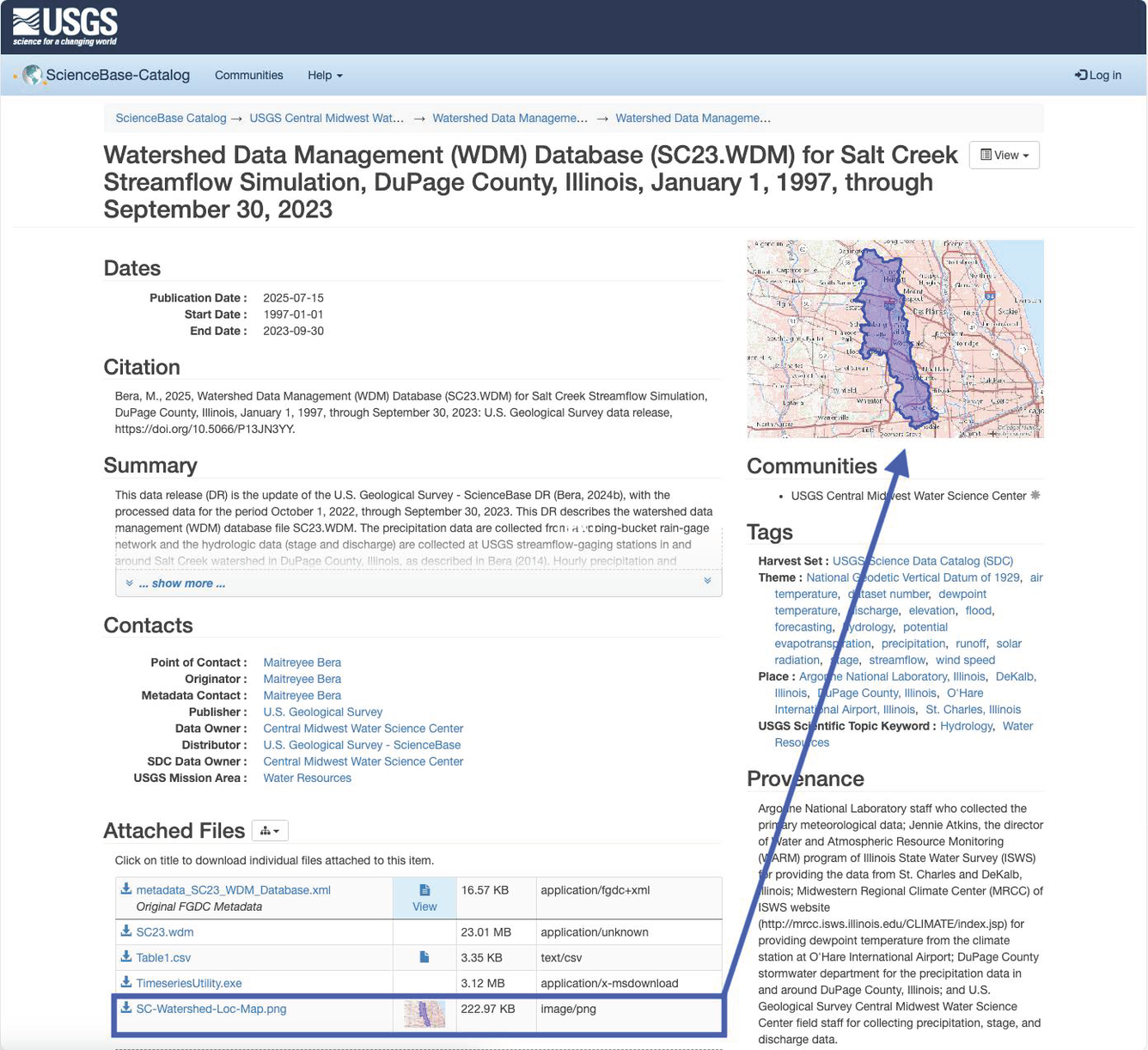
(A screenshot of a ScienceBase data release landing page featuring a static map image in PNG format displayed in the top right corner.)
Map previews have traditionally been populated in ScienceBase when geospatial services are created using geospatial data included on a landing page. Services like Open Geospatial Consortium (OGC) Web Services and ArcGIS Mapping Services can be resource-intensive for the ScienceBase system, and potential issues can arise with map previews when these services have outages. As a general guideline, geospatial services should only be created if a data release contains geospatial data and there's an expectation of user interaction with the data through the services.
If a data release does not include geospatial data, a simple and effective alternative is to upload a static image of a map where the data was collected in .jpg or .png format. This method ensures a seamless display on the landing page while reducing the resource usage of the ScienceBase system.