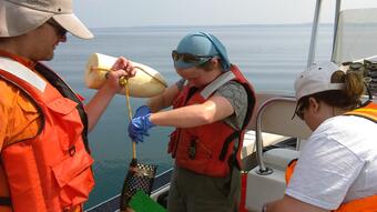
Nutrient pollution is one of America's most widespread, costly and challenging environmental problems. Reduction in nutrient inputs to the Great Lakes is a priority under both the Great lakes Restoration Initiative and the Great Lakes Water Quality Agreement. To support these efforts, USGS scientists across the Great Lakes region are monitoring the transport of nutrients at key locations.

Great Lakes Tributary Monitoring Program
In 2011, the U.S. Geological Survey established a monitoring program on 30 tributaries to the Great Lakes, draining ~46% of the U.S. area and representing a variety of land uses. Discrete measurements of nutrients and suspended sediment, and continuous measurements of flow and water-quality (turbidity, temperature, specific conductance, pH, and dissolved oxygen) are collected in these tributaries to document their water quality characteristics. At present, monitoring is continuing at 26 tributaries to the Great Lakes (24 of the original sites plus 2 additional sites on tributaries to Lake Erie). Regression models are being developed at each site to allow for future “real-time” computation of nutrient and sediment loads.
Tracking Changes in Nutrient Delivery from Western Lake Erie Tributaries
This is a collaborative study involving the USGS and Heidelberg University, focusing on using available, multi-agency water monitoring data in the western Lake Erie basin. A recently developed USGS software tool (“EGRET”; Hirsch and De Cicco, 2015) is being used to evaluate seasonal and annual phosphorus and nitrogen trends and to relate observed trends to climate, streamflow, watershed land use (including land drainage), and monitoring procedures. This approach and planned enhancements to EGRET software will provide adaptive management tools that can be used by water-quality managers to aid in assessing the success of nutrient-reduction efforts in the Lake Erie and other Great Lakes basins.
Great Lakes Connecting Channels Monitoring
The connecting channels of the Great Lakes (St. Clair River, Detroit River, Niagara River, and St. Lawrence River) are major pathways of flow and nutrients between the Lakes and the Atlantic Ocean. However, difficulty in accurately computing nutrient loads in these systems has led to uncertainty in nutrient budgets in many of the Lakes, most notably, Lake Erie and Lake Ontario. Under this effort, the Detroit, Niagara and St. Lawrence rivers will be sampled over a range of flows to quantify composite nutrient concentrations and the dynamics of those concentrations. The results will provide a foundation for computing nutrient loads now and providing a framework for future long-term monitoring and nutrient load estimation.
Lake Ontario Tributary Monitoring and Modeling
This project addresses nutrient and solids dynamics in the nearshore of Lake Ontario to support model development by velocity mapping and loading estimations within the goals of GLWQA Annex 4 and the Lake Ontario LAMP (Lake-Wide Action Management Plan) for long-term loading and trends assessments. The nutrient and eutrophication model is being developed in conjunction with SUNY (State University of New York) Buffalo. The monitoring activities include: tributary solids and nutrient flux; near-shore phytoplankton; in-lake chemicals, nutrients, solids, bottom bivalves, and algal growth; and nearshore velocity mapping.
Nutrient pollution is one of America's most widespread, costly and challenging environmental problems. Reduction in nutrient inputs to the Great Lakes is a priority under both the Great lakes Restoration Initiative and the Great Lakes Water Quality Agreement. To support these efforts, USGS scientists across the Great Lakes region are monitoring the transport of nutrients at key locations.

Great Lakes Tributary Monitoring Program
In 2011, the U.S. Geological Survey established a monitoring program on 30 tributaries to the Great Lakes, draining ~46% of the U.S. area and representing a variety of land uses. Discrete measurements of nutrients and suspended sediment, and continuous measurements of flow and water-quality (turbidity, temperature, specific conductance, pH, and dissolved oxygen) are collected in these tributaries to document their water quality characteristics. At present, monitoring is continuing at 26 tributaries to the Great Lakes (24 of the original sites plus 2 additional sites on tributaries to Lake Erie). Regression models are being developed at each site to allow for future “real-time” computation of nutrient and sediment loads.
Tracking Changes in Nutrient Delivery from Western Lake Erie Tributaries
This is a collaborative study involving the USGS and Heidelberg University, focusing on using available, multi-agency water monitoring data in the western Lake Erie basin. A recently developed USGS software tool (“EGRET”; Hirsch and De Cicco, 2015) is being used to evaluate seasonal and annual phosphorus and nitrogen trends and to relate observed trends to climate, streamflow, watershed land use (including land drainage), and monitoring procedures. This approach and planned enhancements to EGRET software will provide adaptive management tools that can be used by water-quality managers to aid in assessing the success of nutrient-reduction efforts in the Lake Erie and other Great Lakes basins.
Great Lakes Connecting Channels Monitoring
The connecting channels of the Great Lakes (St. Clair River, Detroit River, Niagara River, and St. Lawrence River) are major pathways of flow and nutrients between the Lakes and the Atlantic Ocean. However, difficulty in accurately computing nutrient loads in these systems has led to uncertainty in nutrient budgets in many of the Lakes, most notably, Lake Erie and Lake Ontario. Under this effort, the Detroit, Niagara and St. Lawrence rivers will be sampled over a range of flows to quantify composite nutrient concentrations and the dynamics of those concentrations. The results will provide a foundation for computing nutrient loads now and providing a framework for future long-term monitoring and nutrient load estimation.
Lake Ontario Tributary Monitoring and Modeling
This project addresses nutrient and solids dynamics in the nearshore of Lake Ontario to support model development by velocity mapping and loading estimations within the goals of GLWQA Annex 4 and the Lake Ontario LAMP (Lake-Wide Action Management Plan) for long-term loading and trends assessments. The nutrient and eutrophication model is being developed in conjunction with SUNY (State University of New York) Buffalo. The monitoring activities include: tributary solids and nutrient flux; near-shore phytoplankton; in-lake chemicals, nutrients, solids, bottom bivalves, and algal growth; and nearshore velocity mapping.

