
Bar graphs comparing three partner funding scenarios for completing nationwide 3D Elevation Program data acquisition by 2023.
Allyson Jason
Allyson is the Data Analytics Manager for Topographic Data Services and the 3D Nation Study Co-Coordinator.
Science and Products

3DEP Funding Gap Scenarios
Bar graphs comparing three partner funding scenarios for completing nationwide 3D Elevation Program data acquisition by 2023.
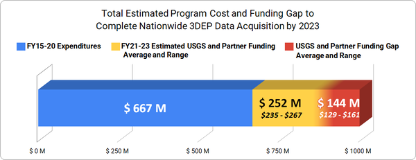
Total Estimated Program Cost and Funding Gap to Complete Nationwide 3D
Total Estimated Program Cost and Funding Gap to Complete Nationwide 3DBar graph showing total estimated program cost and funding gap to complete nationwide 3D Elevation Program data acquisition by 2023
Total Estimated Program Cost and Funding Gap to Complete Nationwide 3D
Total Estimated Program Cost and Funding Gap to Complete Nationwide 3DBar graph showing total estimated program cost and funding gap to complete nationwide 3D Elevation Program data acquisition by 2023

Hydrography Webinar Series - Session 6
The USGS Hydrography Webinar Series shares success stories from users, provides information on The National Hydrography Dataset (NHD) and other related products, and provides a forum for users to learn more about Hydrography-related topics.
The USGS Hydrography Webinar Series shares success stories from users, provides information on The National Hydrography Dataset (NHD) and other related products, and provides a forum for users to learn more about Hydrography-related topics.

Hydrography Webinar Series - Session 5
The USGS Hydrography Webinar Series shares success stories from users, provides information on The National Hydrography Dataset (NHD) and other related products, and provides a forum for users to learn more about Hydrography-related topics.
The USGS Hydrography Webinar Series shares success stories from users, provides information on The National Hydrography Dataset (NHD) and other related products, and provides a forum for users to learn more about Hydrography-related topics.
Science and Products
3DEP Funding Gap Scenarios
Bar graphs comparing three partner funding scenarios for completing nationwide 3D Elevation Program data acquisition by 2023.
Bar graphs comparing three partner funding scenarios for completing nationwide 3D Elevation Program data acquisition by 2023.
Total Estimated Program Cost and Funding Gap to Complete Nationwide 3D
Total Estimated Program Cost and Funding Gap to Complete Nationwide 3DBar graph showing total estimated program cost and funding gap to complete nationwide 3D Elevation Program data acquisition by 2023
Total Estimated Program Cost and Funding Gap to Complete Nationwide 3D
Total Estimated Program Cost and Funding Gap to Complete Nationwide 3DBar graph showing total estimated program cost and funding gap to complete nationwide 3D Elevation Program data acquisition by 2023
Hydrography Webinar Series - Session 6
The USGS Hydrography Webinar Series shares success stories from users, provides information on The National Hydrography Dataset (NHD) and other related products, and provides a forum for users to learn more about Hydrography-related topics.
The USGS Hydrography Webinar Series shares success stories from users, provides information on The National Hydrography Dataset (NHD) and other related products, and provides a forum for users to learn more about Hydrography-related topics.
Hydrography Webinar Series - Session 5
The USGS Hydrography Webinar Series shares success stories from users, provides information on The National Hydrography Dataset (NHD) and other related products, and provides a forum for users to learn more about Hydrography-related topics.
The USGS Hydrography Webinar Series shares success stories from users, provides information on The National Hydrography Dataset (NHD) and other related products, and provides a forum for users to learn more about Hydrography-related topics.