
Water Data for the Nation (WDFN)
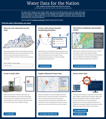
The USGS has a wide variety of tools available to improve the access and understanding of U.S. water information. Water Data for the Nation (WDFN) is the home for USGS’s modernization of public delivery of water data. USGS water data can be accessed by the public in many ways:
- Monitoring Location Pages provide a source of centralized water data, including graphs, stats, and tables of observed water real-time and historical data
- Interactive maps display real-time conditions and allow exploration
- Email and text alerts of real-time water conditions
- Application programming interfaces (APIs) and software packages allow programmatic access
Some of our most popular services are highlighted below. You can also visit the Water Data Blog to view posts that highlight developments, data, and applications of these services.
Centralized Water Data
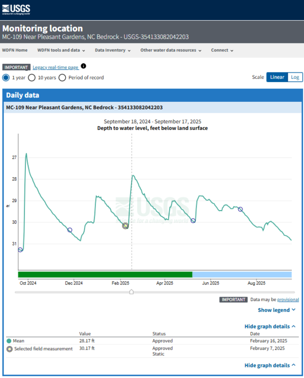
The WDFN Monitoring Location Pages (MLPs) serve as the central entry point for all water data collected at a location. On the MLP, the most recent observations are displayed on a hydrograph at the top of the page. The data types and time period displayed on the graph can be adjusted based on what is available for that monitoring location. In WDFN, all data collection categories are available on the MLP; this is a change from NWISWeb where data collection categories were spread out across multiple web pages.
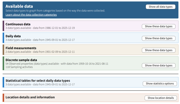
Below the graph on the MLP, you can view the data available at that location. The data available may include continuous data, daily data, field measurements, discrete sample data, statistics derived from daily data, location details, and site information. Continuous data have been delivered on the MLP for several years, and we have recently added additional data collection categories of daily, field measurements, and discrete sample data. Learn more about our approach to centralized water data on our Water Data Blog post.
Current Water Conditions
The USGS provides current water data and weather conditions in real-time or near-real-time conditions at sites across the U.S. via the National Water Dashboard. The National Water Dashboard allows users to explore the latest water data using a map with many available layers including weather and flood forecasts. National trends are easy to understand at a glance based on colors tracking the latest values against historical averages. This tool is available in English and Spanish.
Discover Real-Time Data in your State
On the WDFN State Pages, users can explore what data types are collected at each location or see locations that collect data types of interest by filtering the map and list. State Pages can be accessed from the WDFN homepage. Read more about the State Pages on our Water Data Blog post.
Explore Historic Water Data
Explore USGS Water Data allows users to discover current and historical USGS water data nationwide by location and/or data requirements. Future improvements of the page will allow searching by additional data collections and refining your search results to download data. Learn more about the features of Explore USGS Water Data on our Water Data Blog post.
Create a list of your favorite monitoring locations
The My Favorites page allows users to create a custom list of monitoring locations that can be bookmarked and shared for repeated viewings of key locations. You can also generate data graphs from all your favorite locations on a single page. Read more about the features of My Favorites on our Water Data Blog post.
Create a WaterAlert
WaterAlert is a near-real time hydrologic alerting system that notifies you of stream, lake, and coastal conditions across the nation. Users can subscribe to text or email alerts when water conditions change based on custom thresholds. Read more about WaterAlert on our Water Data Blog post.
Access Water Data through USGS Water Data APIs
We have released new, modernized API endpoints, which will provide the same data that you’re used to but with a new API interface and response format. There are links to a number of different endpoints, including endpoints for other USGS data like the National Imagery Management Service; a centralized location for long-form API documentation; and a signup form for API keys. Read more about our new Water Data APIs on our Water Data Blog post.
Looking for NWISWeb features?
NWISWeb, the web-based interface of the USGS National Water Information System (NWIS), was created in 1995 and has served more than 7 million annual unique visitors and delivered terabytes of data. But as technology has progressed and user needs have changed, we needed to modernize our data delivery. Water Data for the Nation replaces NWISWeb as our public web presence for water data access. Many NWISWeb features are available in WDFN, and additional tools and features will continue to be added. Visit the Water Data Blog for updates and announcements.