
In the summer of 2000 scientists surveyed the lake floor with modern techniques to provide a bathymetric (depth) map for interpreting the postcaldera geologic history.
Clarence Dutton of the USGS led the first expedition to determine the depth of Crater Lake in 1886. With a lead weight and piano wire, Dutton’s party made 168 soundings from a rowboat to determine the lake's depth. The National Park Service made additional soundings of this type between 1938 and 1940.
1959, the US Coast and Geodetic Survey obtained more than 4,000 echo soundings using sonar. Contours of these data revealed the principal features on the floor of Crater Lake – the central platform, Merriam Cone, a small lavadome on the east side of Wizard Island, and the Chaski Bay landslide – for the first time. About the same time, Crater Lake ranger-naturalist C. Hans Nelson collected dredge samples that showed a variety of post–7,700–year eruptive activity. In 1979, Nelson returned to the lake as a USGS marine geologist and used acoustic imaging techniques (like a CAT scan) of the lake floor to discover that as much as 75 m (250 ft) of sediment had accumulated since caldera collapse. The USGS also measured heat flow in the lake floor and discovered areas of very high heat flow that could only be explained by escape of thermal water into the lake.
Interest in exploration for geothermal resources adjacent to the park and concern over potential impacts on the lake led to exploration of the lake floor with a remotely operated vehicle in 1987 then with a manned submersible in 1988 and 1989. This work was conducted by scientists from Oregon State University in cooperation with the National Park Service and the USGS. This survey documented emission of thermal fluids from the lake floor, discovered fossil hot spring deposits, and returned samples of fluids from the deep lake and rocks from post–caldera volcanoes and the caldera walls.
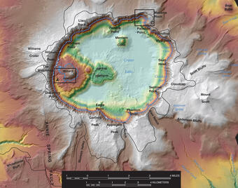
In the summer of 2000 scientists from the USGS, the National Park Service, the University of New Hampshire, and C & C Technologies surveyed the lake floor with modern techniques to provide a bathymetric (depth) map for interpreting the postcaldera geologic history. The information gained from that survey provided a new maximum depth for Crater Lake (594 m, 1,949 ft) and resulted in a detailed map of features on the lake floor. By combining the new bathymetric data with past decades of other research, scientists now have the clearest picture yet of events that happened since the massive eruption 7,700 years ago that destroyed Mount Mazama and created Crater Lake.
In the summer of 2000 scientists surveyed the lake floor with modern techniques to provide a bathymetric (depth) map for interpreting the postcaldera geologic history.
Clarence Dutton of the USGS led the first expedition to determine the depth of Crater Lake in 1886. With a lead weight and piano wire, Dutton’s party made 168 soundings from a rowboat to determine the lake's depth. The National Park Service made additional soundings of this type between 1938 and 1940.
1959, the US Coast and Geodetic Survey obtained more than 4,000 echo soundings using sonar. Contours of these data revealed the principal features on the floor of Crater Lake – the central platform, Merriam Cone, a small lavadome on the east side of Wizard Island, and the Chaski Bay landslide – for the first time. About the same time, Crater Lake ranger-naturalist C. Hans Nelson collected dredge samples that showed a variety of post–7,700–year eruptive activity. In 1979, Nelson returned to the lake as a USGS marine geologist and used acoustic imaging techniques (like a CAT scan) of the lake floor to discover that as much as 75 m (250 ft) of sediment had accumulated since caldera collapse. The USGS also measured heat flow in the lake floor and discovered areas of very high heat flow that could only be explained by escape of thermal water into the lake.
Interest in exploration for geothermal resources adjacent to the park and concern over potential impacts on the lake led to exploration of the lake floor with a remotely operated vehicle in 1987 then with a manned submersible in 1988 and 1989. This work was conducted by scientists from Oregon State University in cooperation with the National Park Service and the USGS. This survey documented emission of thermal fluids from the lake floor, discovered fossil hot spring deposits, and returned samples of fluids from the deep lake and rocks from post–caldera volcanoes and the caldera walls.
In the summer of 2000 scientists from the USGS, the National Park Service, the University of New Hampshire, and C & C Technologies surveyed the lake floor with modern techniques to provide a bathymetric (depth) map for interpreting the postcaldera geologic history. The information gained from that survey provided a new maximum depth for Crater Lake (594 m, 1,949 ft) and resulted in a detailed map of features on the lake floor. By combining the new bathymetric data with past decades of other research, scientists now have the clearest picture yet of events that happened since the massive eruption 7,700 years ago that destroyed Mount Mazama and created Crater Lake.