
The areas at highest risk from pyroclastic flows are the valleys within the wilderness area surrounding the volcano.
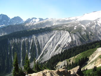
During most of Glacier Peak's eruptive episodes, lava domes have extruded onto the volcano's summit or steep flanks. Parts of these domes collapsed repeatedly to produce pyroclastic flows and ash clouds. The remnants of prehistoric lava domes make up Glacier Peak's main summit as well as its "false summit" known as Disappointment Peak. Pyroclastic flow deposits cover the valley floors east and west of the volcano. Deposits from ash clouds, which lofted above the pyroclastic flows, mantle ridges east of the summit. The areas at highest risk from pyroclastic flows are the valleys within the wilderness area surrounding the volcano. However, ash that lofts off the flows could affect areas downwind from the volcano.
The areas at highest risk from pyroclastic flows are the valleys within the wilderness area surrounding the volcano.
During most of Glacier Peak's eruptive episodes, lava domes have extruded onto the volcano's summit or steep flanks. Parts of these domes collapsed repeatedly to produce pyroclastic flows and ash clouds. The remnants of prehistoric lava domes make up Glacier Peak's main summit as well as its "false summit" known as Disappointment Peak. Pyroclastic flow deposits cover the valley floors east and west of the volcano. Deposits from ash clouds, which lofted above the pyroclastic flows, mantle ridges east of the summit. The areas at highest risk from pyroclastic flows are the valleys within the wilderness area surrounding the volcano. However, ash that lofts off the flows could affect areas downwind from the volcano.