
Close view of weak ocean entry at about 1:05 p.m. HST. Only small and intermittent "laze" plumes have been observed today.
Images
Kīlauea images of eruptive activity, field work, and more.
Filter Total Items: 3089

Kilauea Volcano — Ocean Entry Aerial
Close view of weak ocean entry at about 1:05 p.m. HST. Only small and intermittent "laze" plumes have been observed today.

Kilauea Volcano — Pohoiki Road Lava Flow
View of the now-sluggish lava flow that crossed Pohoiki Road earlier today; the flow originated from fissure 8. This fissure was very active overnight, slowed this morning, and stopped by about noon.
View of the now-sluggish lava flow that crossed Pohoiki Road earlier today; the flow originated from fissure 8. This fissure was very active overnight, slowed this morning, and stopped by about noon.

Kīlauea LERZ Fissures and Flows, May 28, 3:00 p.m.
Kīlauea LERZ Fissures and Flows, May 28, 3:00 p.m.Map as of 3:00 p.m. HST, May 28, 2018. Shaded purple areas indicate lava flows erupted in 1840, 1955, 1960, and 2014-2015.
Kīlauea LERZ Fissures and Flows, May 28, 3:00 p.m.
Kīlauea LERZ Fissures and Flows, May 28, 3:00 p.m.Map as of 3:00 p.m. HST, May 28, 2018. Shaded purple areas indicate lava flows erupted in 1840, 1955, 1960, and 2014-2015.

Kīlauea Volcano — Fissure Complex
View of the fissure complex looking toward the southwest (uprift) during this afternoon's overflight at about 1:15 p.m. HST. The small lava flows spreading to the southeast from the fissure complex (lower middle) originate in the area of between fissures 16 and 18.
View of the fissure complex looking toward the southwest (uprift) during this afternoon's overflight at about 1:15 p.m. HST. The small lava flows spreading to the southeast from the fissure complex (lower middle) originate in the area of between fissures 16 and 18.

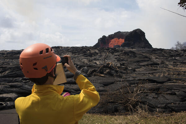
A volcanologist observes a lava fountain during the 2018 Kilauea eruption
A volcanologist observes a lava fountain during the 2018 Kilauea eruptionU.S. Geological Survey Volcanologist Matthew Patrick photographs and observes a lava fountain in the Leilani Estates near Hilo, Hawai`i on Sunday, May 27, 2018.

Kīlauea Volcano — Pāhoehoe Lava Advancement
Pāhoehoe lava advancing west from fissure 7 (lava fountain in background) on Leilani Avenue. Fissure 7 activity increased overnig
Pāhoehoe lava advancing west from fissure 7 (lava fountain in background) on Leilani Avenue. Fissure 7 activity increased overnig

Kīlauea Volcano — Ocean Entry
Aerial view of the ocean-entry areas at about 12:30 p.m. HST. Lava flowing into the ocean diminished overnight and this morning (note lack of obvious plume at the entry areas). View is toward the northwest.
Aerial view of the ocean-entry areas at about 12:30 p.m. HST. Lava flowing into the ocean diminished overnight and this morning (note lack of obvious plume at the entry areas). View is toward the northwest.

Kīlauea Volcano — Enlargement of Summit Eruptive Event
Kīlauea Volcano — Enlargement of Summit Eruptive EventThis image shows radar data acquired by the European Space Agency's Sentinel-1 satellite over Kīlauea Volcano on May 19 at 6:30 PM HST (left) compared to May 25 at 6:30 PM HST (right). The satellite transmits a radar signal toward the surface and measures the strength of the return, with bright areas indicating a strong return and dark areas a weak return.

Fountaining fissure documentation at the Kilauea eruption
Fountaining fissure documentation at the Kilauea eruptionUSGS scientist in the Lower East Rift Zone documenting the spectacular ~50 m tall fissure 7 lava fountain to the east which had lit up the sky in a red hue.
Fountaining fissure documentation at the Kilauea eruption
Fountaining fissure documentation at the Kilauea eruptionUSGS scientist in the Lower East Rift Zone documenting the spectacular ~50 m tall fissure 7 lava fountain to the east which had lit up the sky in a red hue.

Kīlauea Volcano — Aerial of Eastern-Most Fissure Complex
Kīlauea Volcano — Aerial of Eastern-Most Fissure ComplexAerial view of the eastern-most end of the fissure complex (top right) and active lava channels and inactive flows south of the fissures (toward left side of photo) at about 12:30 p.m. HST; the ocean is out of view left side of photo. In this view, fissure 22 in top right is supplying most of the lava to the active channel.

Ash rises above Halema‘uma‘u within Kīlauea's summit caldera
Ash rises above Halema‘uma‘u within Kīlauea's summit calderaAsh rises above Halema‘uma‘u within Kīlauea's summit caldera in this May 27, 2018, telephoto image from near Volcano House Hotel in Hawai‘i Volcanoes National Park.
Ash rises above Halema‘uma‘u within Kīlauea's summit caldera
Ash rises above Halema‘uma‘u within Kīlauea's summit calderaAsh rises above Halema‘uma‘u within Kīlauea's summit caldera in this May 27, 2018, telephoto image from near Volcano House Hotel in Hawai‘i Volcanoes National Park.

Kīlauea Volcano — ‘a‘ā flow
This ‘a‘ā flow, erupted from fissures 7 and 21, was approximately 3–4 meters (yards) high at the flow front and slowly advancing to the northeast in the Leilani Estates subdivision around 10:30 a.m. HST today.
This ‘a‘ā flow, erupted from fissures 7 and 21, was approximately 3–4 meters (yards) high at the flow front and slowly advancing to the northeast in the Leilani Estates subdivision around 10:30 a.m. HST today.

Kīlauea Volcano — Ocean Entry and Laze
An aerial view, looking west, of the two active ocean entries on Kīlauea Volcano's lower East Rift Zone. The large white plume (foreground) is the eastern ocean entry; the weaker, western plume can be seen in the distance.
An aerial view, looking west, of the two active ocean entries on Kīlauea Volcano's lower East Rift Zone. The large white plume (foreground) is the eastern ocean entry; the weaker, western plume can be seen in the distance.

Kīlauea Volcano — Ocean Entry
Aerial view of the active ocean entries at Kīlauea Volcano's lower East Rift Zone captured during this morning's HVO overflight. An ongoing hazard at the ocean entries is laze.
Aerial view of the active ocean entries at Kīlauea Volcano's lower East Rift Zone captured during this morning's HVO overflight. An ongoing hazard at the ocean entries is laze.

Kīlauea Volcano — Lava Channel Merges
Fissures 6 (left) and 13 (right), with lava flows merging into one channel that flows into the ocean at the western-most entry. Note plume in distance at the ocean entries (top left). Photo is from an overflight at mid day.
Fissures 6 (left) and 13 (right), with lava flows merging into one channel that flows into the ocean at the western-most entry. Note plume in distance at the ocean entries (top left). Photo is from an overflight at mid day.

Kīlauea Volcano — Spatter Cone
Activity at fissure 6 this morning (May 25, 2018). Lava fountains have built a small spatter cone (black mound) from which lava was spilling out onto the surface and flowing into a small po
Activity at fissure 6 this morning (May 25, 2018). Lava fountains have built a small spatter cone (black mound) from which lava was spilling out onto the surface and flowing into a small po

Kīlauea LERZ Fissures & Flows, May 25 at 2:00 p.m.
Kīlauea LERZ Fissures & Flows, May 25 at 2:00 p.m.Map as of 2:00 p.m. HST, May 25. Shaded purple areas indicate lava flows erupted in 1840, 1955, 1960, and 2014-2015.
Kīlauea LERZ Fissures & Flows, May 25 at 2:00 p.m.
Kīlauea LERZ Fissures & Flows, May 25 at 2:00 p.m.Map as of 2:00 p.m. HST, May 25. Shaded purple areas indicate lava flows erupted in 1840, 1955, 1960, and 2014-2015.

Kīlauea Volcano —

Kīlauea Volcano — Fissure 6 Lava Fountain
Fissure 6 fountain, as of around 9:30 a.m. HST today.
Fissure 6 fountain, as of around 9:30 a.m. HST today.

Kīlauea LERZ Fissures & Flows, May 24 at 2:20 p.m.
Kīlauea LERZ Fissures & Flows, May 24 at 2:20 p.m.Map as of 2:20 p.m. HST, May 24. Shaded purple areas indicate lava flows erupted in 1840, 1955, 1960, and 2014-2015.
Kīlauea LERZ Fissures & Flows, May 24 at 2:20 p.m.
Kīlauea LERZ Fissures & Flows, May 24 at 2:20 p.m.Map as of 2:20 p.m. HST, May 24. Shaded purple areas indicate lava flows erupted in 1840, 1955, 1960, and 2014-2015.