
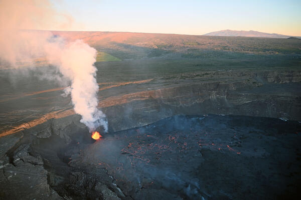
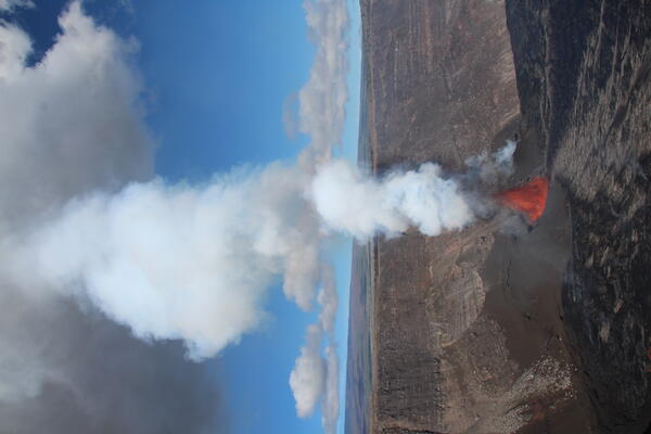
An aerial view of Kīlauea Iki and Pu‘u Pua‘i taken during an overflight of Kīlauea summit on January 10, 2025. Pu‘u Pua‘i, the large cinder cone in the lower right of the image, was formed by lava fountains that reached 580 meters (1,900 ft) during the 1959 Kīlauea IKI eruption. The popular Kīlauea Iki hiking trail is visible across the crater floor.
Images
Kīlauea images of eruptive activity, field work, and more.
Filter Total Items: 3024

January 10, 2025 — Kīlauea Iki
An aerial view of Kīlauea Iki and Pu‘u Pua‘i taken during an overflight of Kīlauea summit on January 10, 2025. Pu‘u Pua‘i, the large cinder cone in the lower right of the image, was formed by lava fountains that reached 580 meters (1,900 ft) during the 1959 Kīlauea IKI eruption. The popular Kīlauea Iki hiking trail is visible across the crater floor.

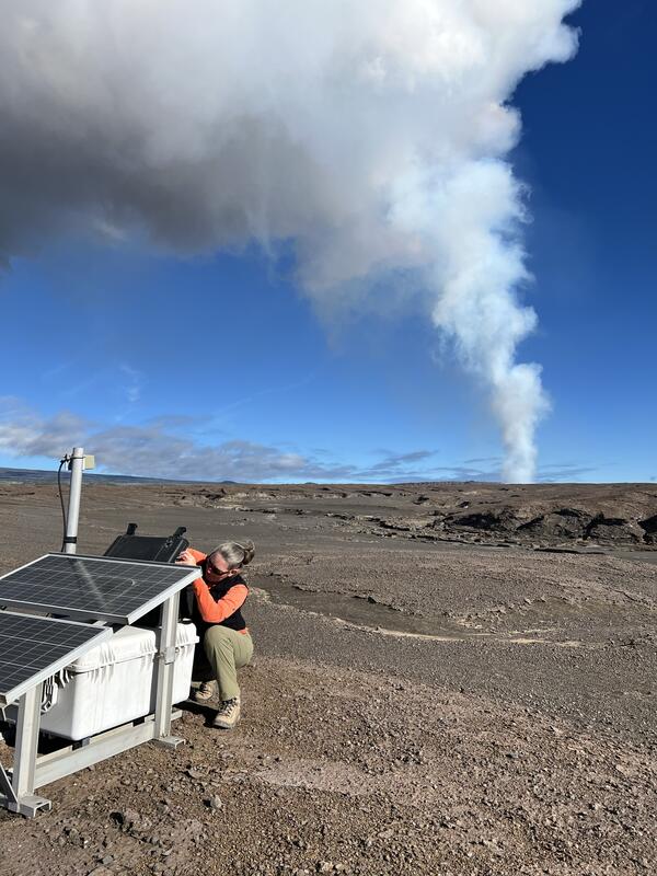
January 10, 2025 — Kīlauea GPS station
On January 10, 2025, USGS Hawaiian Volcano Observatory scientists (HVO) collected data from two semi-permanent GPS sites on Kīlauea's caldera floor. GPS stations record changes in elevation on the caldera floor and can track ground deformation changes that HVO uses for monitoring unrest.
On January 10, 2025, USGS Hawaiian Volcano Observatory scientists (HVO) collected data from two semi-permanent GPS sites on Kīlauea's caldera floor. GPS stations record changes in elevation on the caldera floor and can track ground deformation changes that HVO uses for monitoring unrest.
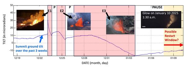
Ground tilt and eruptive episodes associated with Kīlauea summit eruption December 23, 2024, to January 10, 2025
Ground tilt and eruptive episodes associated with Kīlauea summit eruption December 23, 2024, to January 10, 2025Ground tilt and eruptive episodes associated with Kīlauea summit eruption December 23, 2024, to January 10, 2025. Eruptive episodes are highlighted in red. Fountain Episode 1 (E1) began at 2:20 a.m. HST on December 23, 2024, and continued until 4 p.m. that day (14 hours duration). Fountain Episode 2 (E2) began at 8 a.m.
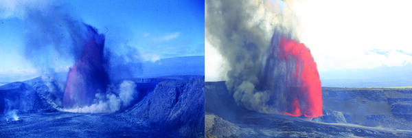
Lava fountains during the Kīlauea Iki eruption in 1959 and Halemaʻumaʻu eruption in 2025
Lava fountains during the Kīlauea Iki eruption in 1959 and Halemaʻumaʻu eruption in 2025Left: Lava fountains on December 14, 1959, during the Kīlauea Iki eruption. Right: Lava fountains on June 11, 2025, during the Halemaʻumaʻu eruption (episode 25). USGS photos.

January 7, 2025 — Kīlauea summit paused eruption observations
January 7, 2025 — Kīlauea summit paused eruption observationsOn the morning of January 7, 2025, USGS Hawaiian Volcano Observatory staff made observations and measurements of the 2024-2025 Halema‘uma‘u vents, which ceased eruption in the evening on January 3, 2025. Both the North and South vents continue to emit volcanic gasses, contributing to vog that has been widespread across the Island of Hawai‘i since Saturday.
January 5, 2025 — Kīlauea caldera overview
Looking out across Kaluapele, Kīlauea summit caldera, from the south rim, small islands of solidified crust dot the area of the lava pond that was fed from the lava fountains during the most recent eruption from December 23, 2024, to January 3, 2025. USGS photo by M. Patrick.
Looking out across Kaluapele, Kīlauea summit caldera, from the south rim, small islands of solidified crust dot the area of the lava pond that was fed from the lava fountains during the most recent eruption from December 23, 2024, to January 3, 2025. USGS photo by M. Patrick.
January 5, 2025 — Kīlauea summit rockfalls
Rockfalls continue from the steep caldera walls of Kaluapele, above the new cinder cone within Halemaʻumaʻu at the summit of Kīlauea. Large blocks roll down the flanks of the cone that formed between December 23, 2024, and January 3, 2025, leaving paths in the tephra cone material. USGS photo by M. Patrick.
Rockfalls continue from the steep caldera walls of Kaluapele, above the new cinder cone within Halemaʻumaʻu at the summit of Kīlauea. Large blocks roll down the flanks of the cone that formed between December 23, 2024, and January 3, 2025, leaving paths in the tephra cone material. USGS photo by M. Patrick.
January 3, 2025 — Kīlauea eruption and Mauna Kea
An early morning view of summit of Mauna Kea, the flank of Mauna Loa, and the current eruption of Kīlauea captured during a USGS Hawaiian Volcano Observatory helicopter overflight. The north vent shutdown at 2:16 p.m. on January 2 after parts of the cone collapsed into the fountain but is still producing a small gas plume to the right of the active fountain.
An early morning view of summit of Mauna Kea, the flank of Mauna Loa, and the current eruption of Kīlauea captured during a USGS Hawaiian Volcano Observatory helicopter overflight. The north vent shutdown at 2:16 p.m. on January 2 after parts of the cone collapsed into the fountain but is still producing a small gas plume to the right of the active fountain.
January 3, 2025 — Kīlauea summit eruption
A view of the large pyroclastic cone that continued lava fountaining at Kīlauea summit has produced against the western wall of the caldera. Lava pours out of the vents into a large, ponded area in the southwest portion of Halema‘uma‘u crater. USGS photo by M. Patrick.
A view of the large pyroclastic cone that continued lava fountaining at Kīlauea summit has produced against the western wall of the caldera. Lava pours out of the vents into a large, ponded area in the southwest portion of Halema‘uma‘u crater. USGS photo by M. Patrick.
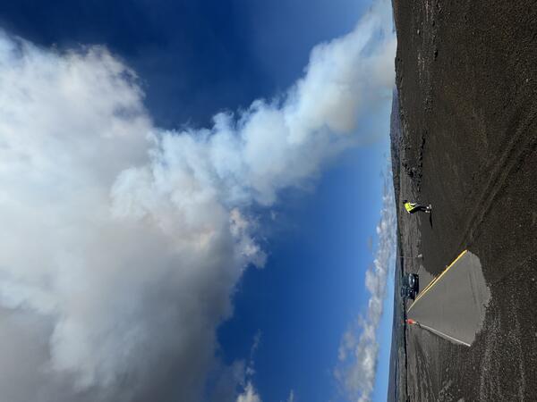
January 3, 2025 — Kīlauea tephra blankets closed road
January 3, 2025 — Kīlauea tephra blankets closed roadPieces of lava (called tephra because they travel through the air before being deposited on the ground) blanket the crater rim downwind of the erupting vents in Kīlauea summit caldera (Kaluapele). Geologists collect samples of this material to analyze later to learn about the magma storage conditions before the eruption.
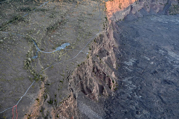
January 3, 2025 — Kīlauea Overlook within Hawaiʻi Volcanoes National Park
January 3, 2025 — Kīlauea Overlook within Hawaiʻi Volcanoes National ParkUSGS Hawaiian Volcano Observatory scientists captured this image of the Kīlauea Overlook within Hawaiʻi Volcanoes National Park during an early morning helicopter overflight on January 3, 2025. Using the cars as a scale, it's easy to see how close the overlook is from the edge of the cliff.
January 3, 2025 — Lava fountain and associated plume at Halema‘uma‘u, Kīlauea, on January 3, 2025
January 3, 2025 — Lava fountain and associated plume at Halema‘uma‘u, Kīlauea, on January 3, 2025This photo, taken from near the S2cam, shows the active lava fountain within Halema‘uma‘u, Kīlauea, the cone (brown) that has built up around the lava fountain, the southwest portion of the lava lake (silver and black), and the rising plume of volcanic gas.

January 3, 2025 — Kīlauea summit eruption overflight
January 3, 2025 — Kīlauea summit eruption overflightHawaiian Volcano Observatory geologists captured this aerial view of Kīlauea summit on January 3, 2025. The shadow of Kīlauea eruption plume is visible on Mauna Loa. USGS photo by M. Patrick.
January 3, 2025 — Kīlauea summit eruption overflight
January 3, 2025 — Kīlauea summit eruption overflightHawaiian Volcano Observatory geologists captured this aerial view of Kīlauea summit on January 3, 2025. The shadow of Kīlauea eruption plume is visible on Mauna Loa. USGS photo by M. Patrick.
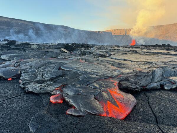
January 3, 2025 — Active Kīlauea lava flow
A close-up view of an active lobe of pāhoehoe lava flowing in Kaluapele, the summit caldera of Kīlauea volcano, on January 3, 2025. USGS photo by M. Patrick.
A close-up view of an active lobe of pāhoehoe lava flowing in Kaluapele, the summit caldera of Kīlauea volcano, on January 3, 2025. USGS photo by M. Patrick.
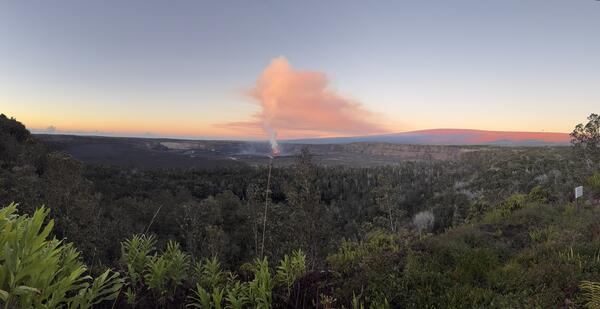
January 3, 2025 — Kīlauea summit eruption plume
From the Volcano House Hotel in Hawaiʻi Volcanoes National Park, the Kīlauea summit eruption plume was visible the morning of January 3, 2025. Mauna Loa is draped in morning alpen-glow in the right side of the image. USGS photo by K. Mulliken.
From the Volcano House Hotel in Hawaiʻi Volcanoes National Park, the Kīlauea summit eruption plume was visible the morning of January 3, 2025. Mauna Loa is draped in morning alpen-glow in the right side of the image. USGS photo by K. Mulliken.
January 3, 2025 — Kīlauea eruption plume
Volcanic gas scientists service one of the volcanic gas monitoring stations downwind of Kīlauea summit, with the eruption plume passing overhead. Sulfur dioxide (SO2) emissions have remained elevated over the past week and were measured as 30,000 tonnes per day on January 2. USGS photo by B. Lopez.
Volcanic gas scientists service one of the volcanic gas monitoring stations downwind of Kīlauea summit, with the eruption plume passing overhead. Sulfur dioxide (SO2) emissions have remained elevated over the past week and were measured as 30,000 tonnes per day on January 2. USGS photo by B. Lopez.
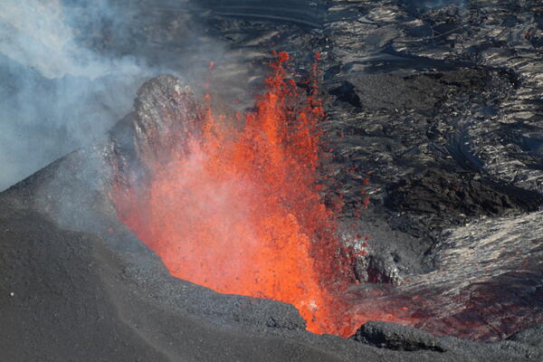
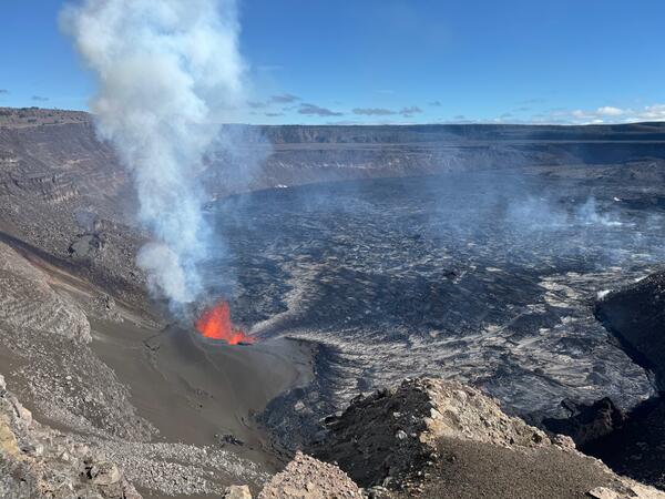
January 3, 2025 — Telephoto view of Kīlauea summit eruption lava fountain
January 3, 2025 — Telephoto view of Kīlauea summit eruption lava fountainThis telephoto view shows the active lava fountain within Halema‘uma‘u as seen from the south looking north. Since the eruption started on December 23, 2024, a 125-foot (38 meter) cone has built up around the lava fountain shown here.

January 2, 2025 — Kīlauea lava fountains
Lava fountaining in the southwest portion of Kaluapele (Kīlauea caldera) has producing tephra cone perched along the caldera wall. USGS photo by M. Patrick on January 2, 2025.
Lava fountaining in the southwest portion of Kaluapele (Kīlauea caldera) has producing tephra cone perched along the caldera wall. USGS photo by M. Patrick on January 2, 2025.

January 2, 2025 — Kīlauea eruptive vents
On January 2, USGS-Hawaiian Volcano Observatory geologists measured lava fountains at Kīlauea summit reaching heights of 262-295 feet (80-90 meters). USGS photo by M. Patrick.
On January 2, USGS-Hawaiian Volcano Observatory geologists measured lava fountains at Kīlauea summit reaching heights of 262-295 feet (80-90 meters). USGS photo by M. Patrick.
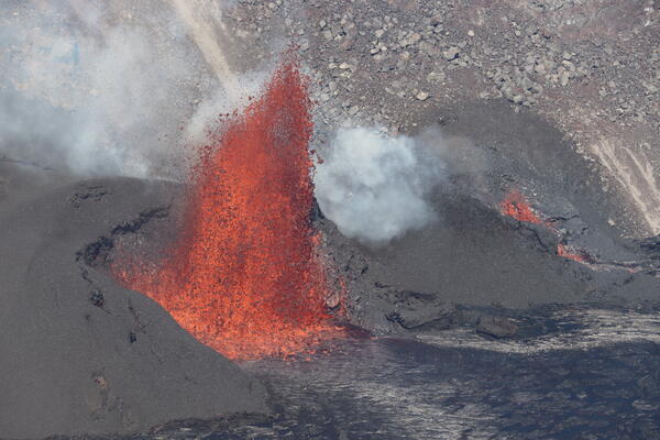
January 2, 2025 — Vigorous lava fountaining continues at Kīlauea summit
January 2, 2025 — Vigorous lava fountaining continues at Kīlauea summitTwo vents were active today at Kīlauea summit. The southern vent was producing the dominant fountain (left side of image) and had built a large pyroclastic cone abutting the western caldera wall. The northern vent had a lower fountain (right side of image) and a smaller cone. USGS photo by M. Patrick.

January 2, 2025 — Kīlauea eruption observations
A view from the west rim of Kaluapele (Kīlauea summit caldera) of the vents erupting at Kīlauea summit. USGS photo by M. Patrick.
A view from the west rim of Kaluapele (Kīlauea summit caldera) of the vents erupting at Kīlauea summit. USGS photo by M. Patrick.