An official website of the United States government
Here's how you know
Official websites use .gov
A .gov website belongs to an official government organization in the United States.
Secure .gov websites use HTTPS
A lock () or https:// means you’ve safely connected to the .gov website. Share sensitive information only on official, secure websites.
Kīlauea's summit eruption continues on the Island of Hawai‘i; Halema‘uma‘u west vent erupts lava into the lava lake, which was 227 m (744 ft) deep this morning, April 23. Gas emissions and seismic activity at the summit remain elevated. HVO field crews—equipped with specialized safety gear—monitor the eruption from with
HVO scientists collect detailed data to assess hazards and understand how the eruption is evolving at Kīlauea's summit, all of which are shared with the National Park Service and emergency managers. Access to this hazardous area is by permission from, and in coordination with, Hawai‘i Volcanoes National Park.
Four-month anniversary of eruption in Halema‘uma‘u
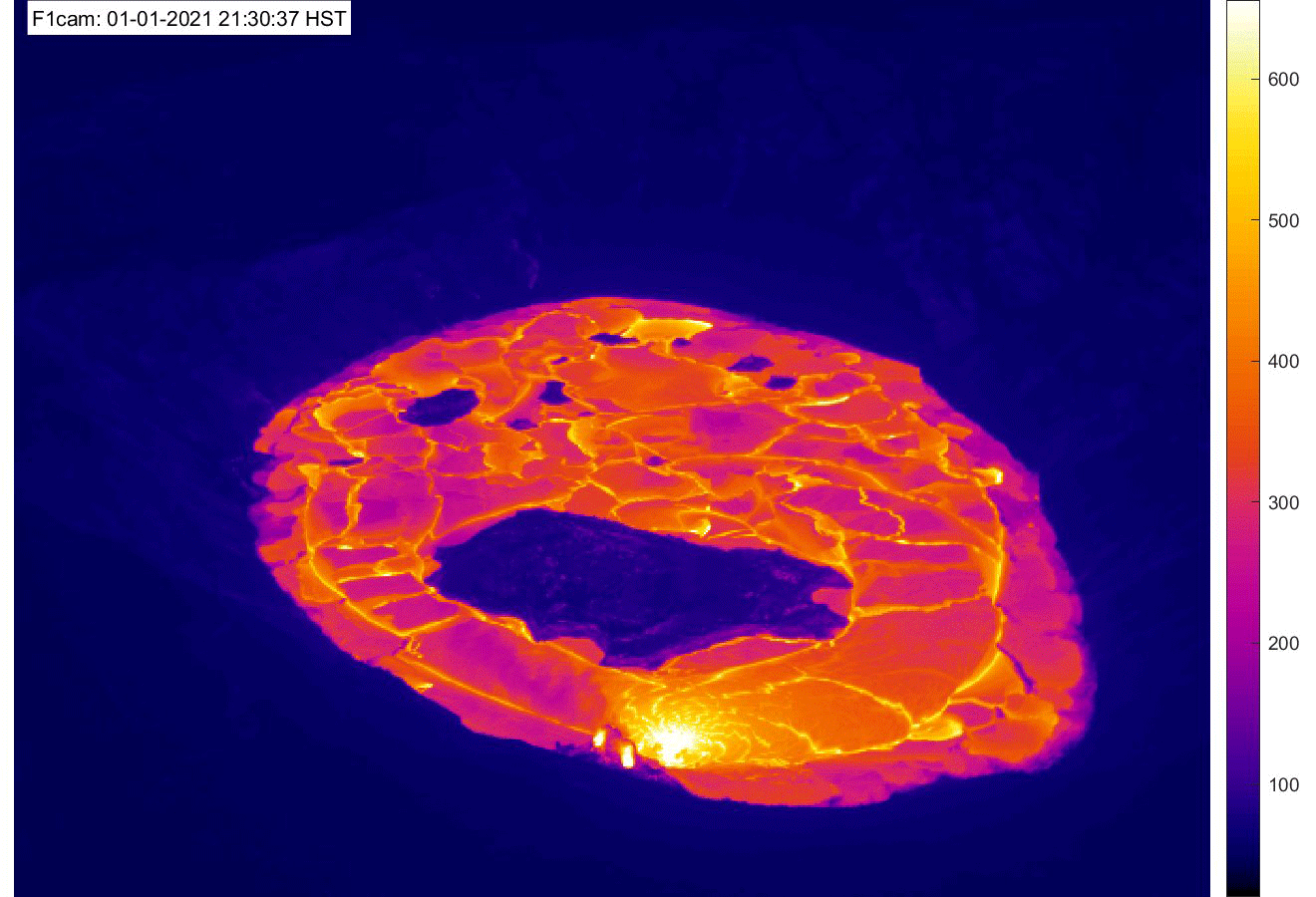
April 20 was the four-month anniversary of Kīlauea's ongoing summit eruption in Halema‘uma‘u. This animated GIF features approximately one thermal image for each day of the eruption and demonstrates eruptive activity over the past four months. At 9:30 p.m. HST on December 20, 2020, vents opened in the northwest and north walls of Halema‘uma‘u, erupting lava and vaporizing the water lake that was at the base of Halema‘uma‘u. A lava lake quickly formed, which continues to fill Halema‘uma‘u crater. Within the first week of the eruption, activity became focused at the west vent area, where it continues today. Initially mobile islands became frozen as the eastern portion of the lava lake surface solidified, and the active western portion of the lava lake has slowly decreased in size as the eruption has progressed. Despite this, the entire lake surface rises as the eruption continues, indicating that the active western portion of the lake is hydraulically connected to the eastern portion beneath its solidified surface. The eastern portion remains molten beneath its surface, and lava occasionally oozes out along the perimeter of the lake as the surface slowly rises. Check the USGS Hawaiian Volcano Observatory F1cam for live thermal images of the active lava lake within Halema‘uma‘u. With National Park Service permission, USGS Hawaiian Volcano Observatory scientists continue to monitor this eruption from within the closed area of Hawai‘i Volcanoes National Park. USGS GIF.
Close-up view of crusting-over lava lake in Halema‘uma‘u, April 22, 2021
This zoomed-in photo of the far southwest end of the active lava lake within Halema‘uma‘u at Kīlauea's summit was captured on Thursday, April 22, and it illustrates the process by which parts of the lava lake become inactive. This area, which had seen substantial lava circulation as recently as last week, now has a stagnant pāhoehoe crust that sits 2–3 m (7–10 ft) lower than the fluid lava surface just to the northeast (right). This crust overlies and possibly overhangs fluid lava underneath, as evidenced by the incandescence visible through a hole along the levee at left. The process starts when the circulation of surficial lava slows in a part of the lake—for reasons that are not entirely clear—allowing the pāhoehoe crust to form. At this point, the area is no longer replenished with new surface lava, and the underlying molten lava will actually contract due to degassing, compression, and cooling. The crust may remain attached to the levees, and as the lava underneath cools and contracts, voids can form below the crust. Eventually, deeper accumulation of molten lava may start lifting this area again, as has happened in the eastern end of the Halema‘uma‘u lava lake. USGS image.
View of Halema‘uma‘u lava lake from the south, April 22, 2021
On Thursday, April 22, HVO scientists observed the ongoing eruption at the Kīlauea summit from the south rim of Halema‘uma‘u. This photo shows the active western portion of the lava lake, which appears to be in the process of shrinking again, with its northeast (upper-right) and southwest (lower-left) ends crusting over substantially. For scale, the distance from the western fissure (upper-left) to the nearest part of the main island in the lake (lower-right) is approximately 180 m or 590 ft. USGS image.